Hurricane Irma has made landfall on the mainland of the Florida Peninsula at Marco Island. The eye is directly over Naples as of the time of this post. As the winds start to shift to the west and southwest in areas south of the eye of Irma, destructive storm surge will rapidly become a serious threat to life and property. The storm has weakened somewhat to a strong Category 2 with 110 mph winds. This does not diminish the wind threat, or the storm surge, flooding rain, and tornado threat.
Current Situation
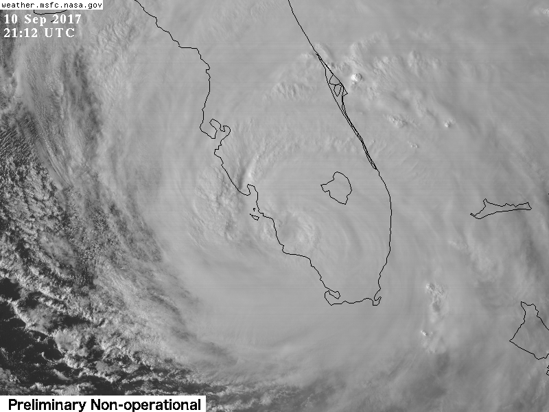
Irma’s eye has filled in again as it’s interacting with Florida. It is a large, powerful storm which easily covers the entire state of Florida. There are still widespread reports of hurricane force wind gusts along the east coast of Florida, despite the eye being on the opposite side of the state.
Headlines
- Storm surge has been flooding the streets of Miami all day. The storm surge threat will become very dangerous for southwest Florida in the next couple hours as the eye moves north along the west coast of Florida. This will bring onshore winds from the west and southwest and push the ocean over land.
- Onshore winds along northern Florida and the Georgia/South Carolina coasts tonight will bring a storm surge risk there as well.
- Wind threat is less serious than it was when Irma was still a strong Category 4, but a 110 mph Category 2 storm is still serious. Wind gusts recorded at Naples reached 142 mph. The northern eyewall is packing the biggest punch and this will continue to advance north along the west coast of Florida.
- Next cities in line for a beating will be Fort Myers, Port Charlotte, and then the Tampa Bay area.
- Tornado warnings have been popping up along the east coast of Florida with some of the stronger bands of Irma.
Forecast Track
It is pretty clear now that Irma will continue north to just west of north as it traverses the state of Florida along its west coast. Tampa Bay is the largest city at risk along this path.

Forecast Intensity
Irma is still expected to maintain hurricane strength until Monday. It should pass over Tampa Bay as a strong Category 2 storm. It will continue to gradually weaken during the next 48 hours followed by more rapid weakening.