Category Archives: Weather Update

NYC Weather Update – May 8, 2017

Weather conditions calm this week after a wet and unsettled weekend. Temperatures continue to trend below normal for this time of the year. Most of the week looks like it will be dry, with the next chance for rain coming over the weekend.

Rest of today – sunny, with a high near 60°F.

Tuesday – sun and clouds, a high again near 60°F.

Wednesday – slightly warmer with high temperatures possibly moving into the low-60s with more sun anticipated. High pressure should hold up enough to prevent any rain associated with a basically stationary low pressure system to our northeast.

Thursday – high temperatures in the low-60s, increasing clouds.

NYC Weekend Weather – May 4, 2017

This weekend brings a drastic change in temperature from the last, with high temperatures fully 20°F cooler. Not only that, but a slow moving upper low pressure system will induce multiple rounds of rain resulting in an extended period of unsettled weather for the area. The most substantial rain occurs Friday. Temperatures remain 5-8°F below normal during this stretch which continues into next week.

Rest of today – enjoy the bright sun shine while it lasts. With high pressure still in control, expect mostly sunny skies and a high temperature in the low-60s.

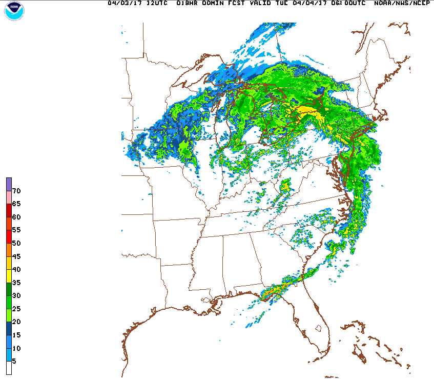
Friday – the same storm system that has been impacting the mid-Mississippi Valley with flooding rains starts to move into our region Friday. Steady rains and embedded thunderstorms throughout the day could bring a total of 1-2″ of rainfall totals. The band of heaviest rains appears likely to cross into the city around 11AM. Temperatures will be about the same as today, in the low-60s, under mostly cloudy skies.

Saturday – unfortunately, due to the slow moving nature of the low pressure system responsible for the rain Friday, there remains a lingering chance for rain Saturday, particular late in the day and into the evening. Temperatures remain cool in the low-60s.

Sunday – improving conditions, with rain chances finally diminishing. There could be some breaks for sun, with high temperatures hovering at just about 60°F.


Drought Almost Totally Gone, Cooler Temperatures Prevail

With all of the plentiful spring rains, only a very small slice of the Hudson Valley remains under abnormally dry conditions. Meanwhile, Climate Prediction Center points to cooler conditions continuing into the next 6-10 days.


NYC Weather Update – Apr 24, 2017

Today through mid-week, we will see mostly cloudy weather, along with soaking rains Tuesday which will also feature temperatures much below normal. Later in the week and into the weekend, we will see a warm up into summer-like weather that should last into the weekend as well. A Bermuda high sets up, a pattern more typical of late June. I will be in Cuba until May 2nd so this will be my last update for the next week at a minimum.

Rest of today – cloudy, high temperatures in the low-60s. Rain developing late and into the overnight Tuesday.

Tuesday – soaking and steady rainfall accompanying a slow moving coastal storm looks set to impact the area for the entirety of Tuesday. Along with this rain, a raw east to northeast wind will make the high temperatures in the low-50s feel even chillier.

Wednesday – showers may linger as Tuesday’s storm slowly pulls away to the east. Temperatures rebound nicely into the mid-60s, could go a touch warmer if clouds break up a bit.

Thursday – a warming trend begins on Thursday with temperatures climbing into the low-70s and mostly sunny skies.

NYC Weekend Weather – Apr 21, 2017

A cool and dreary end of the week leads into a continued stretch of slightly below average temperatures for the weekend. Temperatures remain on the cool side with chances for rain to start next week before a warm up in the second half of next week. Far off in the Central Atlantic, a rare April tropical storm (Arlene) has formed.

Rest of today – rains moved through overnight and lingering showers this morning should end within the next couple hours. Cloudy with high temperatures only in the upper-50s to around 60°F.

Saturday – despite winds turning to the north with high pressure moving in from the west, temperatures should still rebound into the low-60s. Partly to mostly cloudy skies.

Sunday – mostly cloudy to overcast with temperatures hovering around 60°F.

Monday – the next chance for rain comes in along with a developing coastal low that lingers through Tuesday. Timing of this coastal storm remains somewhat uncertain, so it could end up being somewhat of a pest early next week.


Rare April Tropical Storm
We’re still 2 full months off from the official start of the 2017 Atlantic hurricane season, which makes the formation of the first named storm of the season even more of a meteorological oddity. Tropical Storm Arlene will spend its life churning up the waters of the Central Atlantic without any impacts on land. It’s still worth noting that this is only the second time since the dawn of the satellite era that a tropical storm has been detected in April.

TS Arlene is the tight circulation located at around 50° W, 40° N

NYC Weather Update – Apr 17, 2017

The incredible run of summer-like weather we’ve enjoyed the last week comes to a close as a more seasonable weather pattern takes hold this week. Temperatures will range from average to slightly below average and we’ll see a chance for rain late this week.

Tuesday – mostly clear skies with high temperatures in the upper-50s, possibly reaching into the low-60s. An easterly onshore breeze induced by a high pressure center to the northeast will bring cooler these cooler temperatures.

Wednesday – cooler day on tap with increasing clouds and high temperatures in the low-50s.

Thursday – chances for showers as a warm front then cold front push through from Thursday into Friday. High temperatures a bit warmer in the low-60s before the cold front passes.

Friday – chance of rain diminishing through the day with mostly cloudy skies and temperatures again in the low-60s.


Drought Over, Cooler, Wet Pattern in Store

With bountiful spring rains recently and that late winter snow storm, we’ve fully recovered from drought conditions across almost the entirety of the state with the exception of parts of the Hudson Valley and Catskills.

Multiple rounds of storms are expected to favor a cooler and wetter medium term outlook.

NYC Easter Weekend Weather – Apr 14, 2017

The weekend ahead brings some of the warmest temperatures yet for the spring season as a summer-like weather pattern takes shape. The warm up will be short-lived, by Tuesday temperatures will be taking a dip below normal in the upper-50s.

Rest of today – mild, partly cloudy, with high temperatures in the mid-60s.

Saturday – increasing clouds, temperatures cooler in the low-60s.

Sunday (Easter) – very warm, high temperatures in the low-80s. Fog early, sunny otherwise, but with a chance for strong thunderstorms late in the day. A warm front will push through overnight Saturday, and a Bermuda high will take hold. This will lead to very warm air surging from the southwest and the Gulf of Mexico into this region.

Monday – not quite as warm as Sunday, but still quite nice with high temperatures in low-70s and mostly sunny skies.

NYC Weekend Weather – Apr 7, 2017

After a week of alternating days of wet and windy weather, we look ahead to improving conditions over the weekend and leading into next week. Sunny days with temperatures averaging anywhere between 5-10ºF above normal are right around the corner.

Rest of today – one of the last days of cooler than average weather we’ll see for a while. Temperatures hover in the low-50s with mostly cloudy skies. There is a chance for a passing shower with instability and moisture in the atmosphere from the backside of yesterday’s storm exiting east.


Saturday – skies clear, though temperatures remain below normal with high temperatures in the low-50s.

Sunday – a warm up begins as high pressure builds to the south of us. Clockwise flow around this high pressure brings warmer air in from the southwest. Temperatures warm into the mid-60s with sunny skies.

Monday – superb conditions for the Yankee’s home opener with sunny skies and high temperatures in the upper-60s to about 70ºF and sunny skies.


Drought Busted

The many rounds of rain we’ve seen over the course of the last couple weeks have finally busted the remaining drought conditions in the city itself and Long Island, just in time for the start of the growing season. Moderate drought still persists further north in the Hudson Valley.

NYC Weather Update – Apr 3, 2017

wwwThe first week of April kicks off with multiple rounds of rain. Two separate storms are expected to bring drenching rains on Tuesday and Thursday. There may be some minor flooding concerns with 1″ of rain possible out of each system, on top of the rains we received last week.

Rest of today – cloudy, mild, with high temperatures in the upper-50s. Not a bad day for the Mets season opener.

Tuesday – late Monday, rain starts moving in ahead of an advancing warm front. Rain should begin around 10PM this evening and pick up in intensity overnight. Some thunderstorms are possible. Rain continues through most of the work day Tuesday, with some heavy rain possible. Mild again with high temperatures in the upper-50s.

Wednesday – brief respite between two storm systems, a gem of a spring day with high temperatures in the low-60s and mostly sunny to clear skies.

Thursday – temperatures cool off into the low-50s as the second storm system of the week impacts us and brings us yet another round of moderate to heavy rains.


NYC Weekend Weather – Mar 31, 2017

March ends on rainy note. It’s been a cooler and wetter month than average, after a much warmer February. The snow and rain has made significant positive impacts on the drought in this region. We get one good day this weekend, before more rain moves in to start the first week of April.

Rest of today – overcast, periods of rain, heavy at times due to a slow moving low pressure center. The heavier rains look to come later this evening into the overnight hours. Easterly and northeasterly winds will make it feel cooler than the high of around 40ºF.

Saturday – due to the slow pace of this storm, rain is still likely to be falling early tomorrow. High temperatures will remain well below normal due to the continued onshore easterly winds and cloud cover, only reaching the mid-40s.

Sunday – with the low pressure center finally exiting east, we should see dramatically improved conditions with highs rebounding to normal levels in the mid-50s and lots of sunshine.

Monday – starts off similar to Sunday with mostly sunny skies and temperatures in the mid-50s. Conditions deteriorate later in the day as the next storm system starts moving in.


Average Temperatures, Above Average Precipitation to Start April

Due to the influence of several storm systems forecast to impact the area, we’re expecting normal temperatures and above average precipitation to start the month off.

NYC Weather Update – Mar 27, 2017

Active weather pattern to start the week brings us multiple chances for rain. Things settle down mid-week, but another chance for rain comes up late week and into the weekend. Beneficial rains and the snow from the last Nor’easter has put a significant dent in drought conditions area wide. It looks like we’ve turned the corner legitimately towards spring with average to above-average temperatures expected for the foreseeable future.

Rest of today – rain tapering off by the early afternoon. Some clearing possible later. High temperatures in the mid-upper 50s.

Tuesday – mild, high temperatures around 60°F, slight chance for rain lingers throughout the day with a cold front approaching from the west.

Wednesday – rain is likely overnight Tuesday into Wednesday as this cold front moves through. On Wendesday itself, after the cold front pushes through, gradual improvement in weather conditions is expected with clouds breaking and a high in the mid-upper 50s.

Thursday – best day out of the week with high temperatures right around average in the low-50s and plenty of sunshine.


Temperature, Precipitation Trends and Drought Update

Over the course of the next week to week and a half, we’re expected to see average to slightly above average temperatures along with slightly above average rainfall. This bodes well for the overall drought situation which has seen marked improvement since the region received significant snowfall from the last Nor’easter and winter storm.