Category Archives: Northwest

WxChallenge for Portland International Airport (KPDX) | Oct 2-5

Last Week’s Results

After the first week of the WxChallenge (and part of this week), I’m second place in my class, tied with multiple others for #268 nationwide, and a little better than national consensus with 21.2 error points. I got hit the last day for going over on temperatures and winds, and will discuss that below. Hats off to one of my classmates who’s currently #44 nationwide!

Verifications

Below are the verified readings for each metric we were asked to forecast during last week, and a column showing error points I was assessed.

Forecast Day Max Temp (°F) Min Temp (°F) Max Sustained Wind (kts) Precipitation (inches) Error Points Assessed
09/25/2018 82 50 11 0.00 4.0
09/26/2018 83 52 11 0.00 1.0
09/27/2018 84 52 9 0.00 2.5
09/28/2018 86 53 11 0.00 6.5

Post-Mortem

Day 1: went too aggressive on the max winds, and too warm on the low temps. The lower winds could explain the lower min temps (less mixing on clear nights). I think I was too optimistic about the possibility of funneling of winds from the ENE along the Columbia River Gorge.

Day 2: did pretty well, only got 1 point off for missing the high temp slightly. If I had stayed with my original forecast for that I would have had a perfect score! Much better on winds though.

Day 3 & Day 4: another decent day, but went a little too cool with the low temperatures. This low bias also bled into Day 4, where I was low on both the high, low, and max sustained wind speeds. I think if I were to go back and redo this, maybe I would have used the Delta Method (a form of moderate persistence) and been better off than looking at MOS, given how stable conditions were throughout the week.

Forecasting for KPDX October 2-5, 2018

Synoptic Set Up

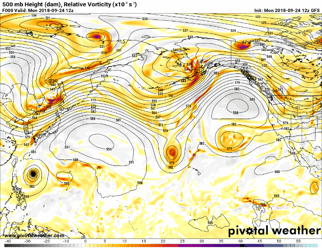
Big changes in store for Oregon in the second week of the forecast challenge. The rex block and high pressure that brought a week of above normal warmth and clear skies last week will finally break down. The upper low associated with it will move northeast towards KPDX over the weekend. Local NWS forecasters currently (as of Thursday) noted considerable spread in forecast guidance about phasing of northern stream energy and a second upper low by the beginning of this forecast period, as well as interaction with outflow from Hurricane Rosa. AFD mentions longwave troughing as well, and this is backed up by GFS progs.

Rainy start to the week at KPDX possible
Coastal low coming ashore on Friday at KPDX


Forecast Rationale

The effects of the synoptic set up favor much cooler and unsettled conditions compared to last week. A drop in 500 mb heights with upper lows and longwave trough should result in temperatures close to or slightly below climatological norms. The prospect of this troughing means that precipitation will be in the mix as well at the start of the week. More substantial rain chances are in store for KPDX to end the week. Along with the rain Friday, we can expect cooler temperatures and windy weather as rain cooled air helps mix down some momentum from the lower atmosphere.

Forecasts Submitted

This only reflects finalized forecasts as of this posting, I’ve made small adjustments to the forecast based on checking MOS daily.

Forecast Day Max Temp (°F) Min Temp (°F) Max Sustained Wind (kts) Precipitation (inches)
10/02/2018 68 54 11 0.05
10/03/2018 67 45 7 0.00
10/04/2018 66 46 7 0.00
10/05/2018 57 49 15 0.28

WxChallenge for Portland International Airport (KPDX) | Sept 25-28

Temporary Changes to this Blog

Over the next few weeks, I’m going to take a break from my normal posts about weather in NYC and the region because I’m participating in the WxChallenge national weather forecasting competition. This is a course requirement for the final semester of the Undergraduate Certificate in Weather Forecasting program with Penn State University’s World Campus that I’m enrolled in. During the course of this competition, I will be providing forecasts of high temperatures, low temperatures, maximum sustained winds, and total precipitation for various cities in the challenge. The first of these cities will be Portland, Oregon – specifically Portland International Airport (KPDX). If events of particular interest, such as severe weather, tropical storms, or etc are forecast to occur in NYC, I will make special posts regarding such events.

Forecasting for KPDX September 25-28, 2018

Synoptic Set Up (The Big Picture)

High pressure was located at the surface west of KPDX. A rex blocking pattern existed over the Pacific (a upper level high directly north of an upper level low, see animation below, the upper level high is west of OR/WA and shaded with some light blues, the upper level low just south of it shaded with oranges/reds). Some northeasterly winds were forecast during the forecast days, especially later in the day/overnight, which given the topography surrounding KPDX would lead to some downsloping. Still, northwesterly was forecast to be the predominant wind direction, which aligns well with climatological norms for September. A thermal low was mentioned to be in place through the mid-week period that would migrate daily from west to east.

Forecast Rationale

The synoptic set up favors little change in day-to-day conditions. Downsloping and the presence of a thermal low over the Willamette Valley suggest warmer than climatological and MOS (Model Output Statistics) guidance max temps. Despite mostly clear to clear skies throughout the forecast period, radiational cooling at night should be limited due to winds expected to be easterly overnight. When there are clear skies with no/calm winds, this allows infrared radiation to efficiently escape into space from the Earth’s surface, resulting in cooler temperatures when compared with a cloudy and/or windy night. Of note, easterly winds produce the fastest winds for KPDX due to some funneling effects from the Columbia River Gorge (think of this like blowing through a straw). This was referenced in the local forecast AFD. However, the MOS guidance didn’t really show a clear signal of wind directions favorable to strong funneling, so it would be unwise to go too much above guidance here. Late week cool down noted as the rex block breaks down and the upper low that was associated with makes its way towards the west coast. Exact placement/timing could bring some precipitation in the picture by the weekend and maybe early into week 2 forecast period.

Forecast Submitted

Forecast Day Max Temp (°F) Min Temp (°F) Max Sustained Wind

(knots)

Precipitation (inches)
09/25/2018 82 52 15 0.00
09/26/2018 82 52 11 0.00
09/27/2018 85 54 8 0.00
09/28/2018 83 55 6 0.00

NYC Weather Update – Mar 27, 2014

We’re entering into a pattern of active weather through the weekend and into early next week. Today will be dry and pleasant, though well below normal with highs only in the mid 40s.

High pressure will move east of NYC before a cold front approaches from our west on Friday. Southwest flow around the high pressure center and ahead of the frontal boundary will usher in milder, moist air from the southeast. Temperatures on Friday will be near normal in the mid 50s. As the front passes through, expect periodic rain showers throughout the afternoon hours.

Saturday – a second frontal system is forecast to spawn a low that will track offshore of the East Coast, bringing a second round of rain to the area. This round will be heavier than Friday’s, with ample moisture available for the storm to draw on. With the clouds and rain, high temperatures will be suppressed to around 50.

Sunday – there is some uncertainty about how quickly the low impacting us Saturday will exit the region. At this time, it does appear that rain will continue through portions of the day. Should the low be slow to exit, colder air could work into the system allowing for accumulating snow Sunday night! High temperatures Sunday will be in the mid 40s.

Monday – should be a fair day, dry, with high temperatures near normal in the mid 50s. So, even if it snows on Sunday, the snow will melt rapidly. Next shot at precipitation comes with another frontal system Tuesday.

Check out the cumulative quantitative precipitation forecast from the National Weather Service’s Weather Prediction Center for Thursday through Sunday morning. Note that our area is forecast to receive as much as 2.5″ of precipitation through Sunday. Also, there are pockets of as much as 4-6″ of precipitation forecast for the West Coast. For California, that’s some good news as it will help with the drought conditions, but as we saw with Oso, Washington mudslide this much precipitation in such a short span of time can lead to landslides. This is especially the case for Oregon and Washington which are no longer as drought-stricken and soil saturated from previous storms.

Untitled

Below is a NAVGEM forecast model run depicting two storms simultaneously impacting the West Coast and the Northeast on Sunday.

Untitled1

NYC Weather Update – Mar 17, 2014

We were fortunate to avoid a white Monday, as our friends to the south in NJ, DC, and Philadelphia got hit with between 4-9″ of snow during this last storm. Once again, despite temperatures being cold enough, we missed the area with higher moisture content, and dry air took the day, leading to some light flurries but no accumulation.

Check out the snow total map for the DC, Maryland, Delaware, and Southern NJ region below:

Screen shot 2014-03-17 at 3.18.53 PM

Looking ahead to the rest of the week, it looks like the formal start of Spring will bring a significant warmup for the area.

Tuesday – A sunny day as the departing storm and associated clouds clear out overnight. Good conditions for radiational cooling will mean a cold start to the day with lows in the mid 20s. However, ample sun will boost high temps up to near 40.

Wednesday – the next storm system approaches overnight Tuesday into Wednesday. A low pressure center will pass over the Great Lakes and to our north, with an accompanying trailing cold front. Temps ahead of the cold front will warm up to near normal for this time of year in the upper 40s, near 50. The cold front will bring along light showery precipitation during the afternoon Wednesday. See forecast diagram from the National Weather Service below:

Screen shot 2014-03-17 at 3.12.38 PM

End of the week will feature high pressure over the area with milder temps near the seasonal average of 50, and fair conditions. The next storm system is forecast to enter the area Friday night into Saturday.

Strong Pacific Storm Possible 10 Days

Parts of the west coast continue to see some abatement of drought conditions, with significant improvement for portions of Oregon and Northern California. Nine of twelve GFS model ensemble members are forecasting a strong Pacific storm coming ashore mid-week next week, which is good news for areas that could definitely use the rain. Below are two of the ensemble members. Note the fairly tight isobars denoting pressure, indicating a strong low pressure center.Screen shot 2014-03-17 at 3.11.55 PM

Active Weather Pattern to Bring Relief to Drought Stricken West

Weather Prediction Center’s medium range forecast


Over the past couple of months, exceptional drought conditions have developed over large portions of the western UnitedStates caused by prolonged periods without measurable precipitation. It was not long ago that parts of California were literally on fire.

This past week, West Coast folks finally got some relief as rain and snow fell over portions of the Pacific Northwest and California, including the Cascades and the Sierra. As of today, winter storm warnings and advisories are up for much of the same region. The snow will be critical especially for the Central Valley of California. Annual snowmelt from the Sierra feeds the rivers and streams that farmers depend on to grow the abundant veggies and fruits that we get to enjoy across the nation.

This active weather pattern will continue for the west coast, with another area of low pressure forecast to slide southeast from the northeastern Pacific Ocean by Tuesday (see above). However, the long-term drought outlook still calls for persistence or deterioration. Either way, people out on the west coast are probably happy to see any precipitation.