Muggy with thunderstorms rolling through later this afternoon and highs in the upper-70s. The story this weekend is about building heat and humidity. A Bermuda high becomes the dominant feature bringing an extended period of 90ºF+ heat into next week. While this high is anchored in the western Atlantic, we won’t see any appreciable chances for rain at least until later in the week next week.
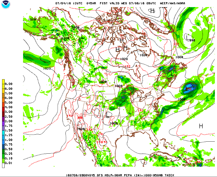
Rest of today – mostly cloudy with high temperatures in the upper-70s. HRRR simulated radar runs this morning consistently signalling the arrival of a line of thunderstorms around 3-4PM this afternoon. Behind these storms, temperatures overnight expected to be in the mid-60s.
HRRR rapid refresh simulated 1-km radar valid 3:30 PM later today showing a cluster/line of thunderstorms moving through the NYC area.
Saturday – sunny with high temperatures much warmer in the upper-80s. Overnight lows in the low-70s. Humidity will be building as well due to the influence of southwesterly/westerly flow bringing in a warmer and moisture-laden air mass.
Sunday – high temperatures around 90ºF with mostly sunny skies. Overnight lows in the low-70s.
GFS model 1000-500 mb thickness and surface conditions valid 8 PM Sunday. You can see a sprawling high pressure center in the Atlantic. Clockwise anticyclonic flow from the south/southwesterly flow around the periphery of this high will advect hot, humid air towards our area.
Monday– with a Bermuda high still in place, expect high temperatures to once again reach around 90ºF with higher heat index values due to the humidity. Overnight lows in the low-70s.
A cold front that pushed through overnight leaves us with some cool, crisp air to start the weekend. The first half of the weekend will be characterized by plenty of sun before a slow moving frontal system approaches later in the weekend. This will bring back chances for showers and thunderstorms going into next week when it appears an active weather pattern could take root.
Rest of today – mostly sunny with high temperatures in the mid-70s. A post-frontal trough may touch off a few isolated storms later in the afternoon. Overnight lows in the low-60s.
Weather Prediction Center surface forecast for 8AM Saturday, showing high pressure off the coast of NC
Saturday – mostly sunny with highs in the low-80s. High pressure takes hold off the Southeast US coast, with clockwise return flow bringing some warmer air this way. Overnight lows in the low-60s.
Sunday – with a frontal boundary approaching from the northwest, clouds increase and chances for showers and thunderstorms do also. High temperatures should still be mild in the low-80s. As the Overnight lows in the mid-60s with rain chances continuing.
NAM output of 1000-500 mb thickness, surface pressure and precipitation for 8PM Sunday.
Monday – the frontal boundary that approaches from the northwest weakens and stalls out. This is partly due to flow at the upper levels flattening out/becoming somewhat parallel to the front’s orientation, and partly due to the high pressure that by this time will become anchored over Bermuda. Multiple waves of low pressure are forecast to move along this stalled front bringing another day that holds chances for showers and thunderstorms. Prolonged southwest/westerly flow ahead of the cold front which really slows down should allow temperatures to reach the mid-80s despite more cloud cover and precipitation. Overnight lows in the upper-60s with yet more rain possible.
The dog days of summer arrive in full force this week before we close out the month of August. With a strong Bermuda high in place well southeast and secondary high pressure in the area, we will see a heat wave take place from today into Thursday. Several days of hot, humid weather are on tap until a cold front moves through Thursday, bringing the potential for strong thunderstorms and much cooler air in its wake.
Rest of today – hot, though not quite as humid as it will be later this week. High temperatures in the low-90s with mostly sunny skies expected.
Tuesday – even hotter, and more humid than today with high temperatures in the mid-90s with sunny skies.
Wednesday – yet another hot, oppressively humid day with high temperatures in the mid-90s. Both Tuesday and Wednesday should see heat index values above 100°F due to high dew point values as well.
Thursday – a cold front is forecast to push through the area Thursday. Along and ahead of this front, we are expecting the chance for some scattered strong to severe thunderstorms given the ample moisture available and hot temperatures. Temperatures will still be hot, in the low-90s, before this frontal boundary passes through. Behind this cold front, temperatures will be 10-15°F cooler Friday into the weekend.
Got retrained as a SKYWARN spotter last night – this weekend should be tranquil though. A steady warming trend begins this weekend and lasts through mid-week next week. After a prolonged period of cool and unsettled weather, we could see the second heatwave of the season. Great weekend for a getaway to the beach!
Rest of today – mostly sunny, temperatures in the upper-70s to around 80º. Some residual instability in the wake of a low pressure center exiting the Northeast may touch off a couple isolated showers or thunderstorms.
Saturday – the warmup continues with temperatures climbing into the low-80s. Isolated showers and thunderstorms are possible again in the afternoon hours with the passage of an upper level disturbance.
Sunday – the heat arrives in earnest as a Bermuda high sets up and begins to strengthen. This will begin pumping in warmer and more humid air from the south and southwest. Temperatures are expected to climb into the low-90s in the city with sunny skies, with cooler temperatures due to the sea breeze on south-facing shores in the mid-80s. Great beach day, and ideal conditions for the annual Puerto Rican Day Parade.
Monday – the heat continues with temperatures again in the low-90s with some spots in the mid-90s and sunny skies. There could be a heat advisory up at some point.
Dramatic changes are in store for us this week with respect to the temperature. Mid-summer heat and humidity reach their apex on Thursday with high temperatures climbing into the mid-upper 80s except for areas affected by a sea breeze. For the first time in a while, we will see an extended stretch of dry weather.
Rest of today – very windy with northwest winds 25mph and higher gusts due to the pressure gradient between this weekend’s Nor’easter exiting east and high pressure building to to the west. Wind advisories are up for the city. High temperatures into the mid-60s.
Tuesday – sunny, and a warmup begins with temperatures climbing to the mid-70s.
Wednesday – warmer still, with lots of sun and high temperatures in the low-80s.
Thursday – the warmest day of the week with temperatures reaching well into the mid-upper 80s. High pressure from earlier in the week will slide southeast and eventually build over Bermuda. This is a classic setup that favors warm and humid conditions on the Eastern seaboard as warm air from the gulf and tropics rushes from the southwest clockwise around the high pressure.
Drought Completely Gone
For the first time in a year, no drought conditions existed anywhere in New York State.
The weekend ahead brings some of the warmest temperatures yet for the spring season as a summer-like weather pattern takes shape. The warm up will be short-lived, by Tuesday temperatures will be taking a dip below normal in the upper-50s.
Rest of today – mild, partly cloudy, with high temperatures in the mid-60s.
Saturday – increasing clouds, temperatures cooler in the low-60s.
Sunday (Easter) – very warm, high temperatures in the low-80s. Fog early, sunny otherwise, but with a chance for strong thunderstorms late in the day. A warm front will push through overnight Saturday, and a Bermuda high will take hold. This will lead to very warm air surging from the southwest and the Gulf of Mexico into this region.
Monday – not quite as warm as Sunday, but still quite nice with high temperatures in low-70s and mostly sunny skies.
This week will see a marked transition from seasonable high temperatures in the low-40s to a much warmer period mid-late week that will be reminiscent of this past weekend’s record-breaking warmth. The only blemish on this spring preview is a slight chance for rain overnight Tuesday. Looking ahead, it appears March will be far from a lamb this year with a few storms rolling our way.
Rest of today – mild and above average with temperatures in the mid-upper 40s. Clear skies overhead. This will continue overnight and allow for good radiational cooling leading to overnight lows in the low-30s.
Tuesday – seasonable with high temperatures in the low-40s under mostly sunny skies.
Wednesday – a warm up begins as a summer-like high pressure area sets up over Bermuda. This high pressure will induce a southwest flow ahead of a cold front to the west that will push warm air from the Southeast to our region. The result will be increasing clouds but high temperatures near 60°F.
Thursday – even warmer, with high temperatures reaching well into the mid-upper 60s with mostly sunny skies.
Warm Temperatures to Continue Through Weekend
I suppose Staten Island Chuck was right when he predicted a short winter, because it looks like above normal temperatures are expected through the end of this month. This weekend, look forward to more temperatures near 60ºF.
The second half of this week and this weekend will feel as though we’re living in a tropical monsoon climate zone, given the extended period of unsettled weather that we’ll be experiencing. Nearly every day over the course of the next 5-7 days, we’ll see a chance for showers and thunderstorms, some capable of producing torrential rainfall, along with a very warm and humid airmass staying in place.
Rest of today – periods of clouds and sun, likely becoming mostly cloudy this afternoon. There will be a chance for showers and thunderstorms, with the first batch appearing to arrive around lunch. High temperatures will be around 90ºF but with the very humid air, heat indexes will be well into the upper-90s. This is the reason for there being a Heat Advisory in place until Saturday evening.
Friday – similar set up to today, periods of sun mixed in with mostly cloudy spans as well. Highs will again be around 90ºF, with a chance for showers and thunderstorms in the afternoon hours. The exact timing, placement, and intensity of the storms for Friday and this entire forecast period will be difficult to forecast with accuracy ahead of time.
This is due to the fact that many of the storms will be driven by subtle perturbations in the atmosphere moving around the periphery of a Bermuda High, and differential day time heating – hence why the chance for showers and thunderstorms is greatest in the afternoon hours. Sea breeze convergence boundaries are likely to serve as triggers for these storms. This Bermuda High is what has been and will be responsible for maintaining the oppressively hot and humid conditions. The tropical airmass it brings will mean that any storms that form will have the potential to tap into tropical moisture and produce very heavy rain that could lead to localized flash flooding.
Saturday – will be by far the hottest day of the weekend with high temperatures forecast to reach into the mid-upper 90s. Heat indexes will be in the upper-90s to low-100s in some parts, likely triggering Excessive Heat Warnings. Once again, a chance for showers and thunderstorms will occur in the afternoon hours.
Sunday – a cold front will approach the region on Sunday, which will lead to a more consistent and higher chance for organized thunderstorm activity. High temperatures will remain hot, in the low-90s.
Monday – low confidence for the forecast through Monday, as the timing of the cold front passage is uncertain. It may linger, which would result in yet more chances for rain. High temperatures should cool off to below 90ºF in the upper-80s.
Rain moves through tonight, and then temperatures warm through the course of the week as a Bermuda high takes control. There’s a chance for showers and thunderstorms Thursday – otherwise this week will certainly feel like summer.
Rest of today (Independence Day) – increasingly cloudy, with a high near 85ºF. Forecasts last week seemed to indicate a rain-free weekend outside of Friday night when we experienced some severe thunderstorms. It now appears that an area of low pressure tracking to our south will bring rain to the area tonight. Currently, the timing of the rain appears to bring it in the city right around the time that the fireworks display is scheduled to kick off. The heaviest rain won’t begin falling until later tonight, so I don’t think this will wash the fireworks out, but it will result in less than ideal viewing conditions if you plan on being outside at the display.
Tuesday – steady rains should end by the morning rush tomorrow, though a lingering shower could pop up till around noon. Decreasing clouds with high temperatures in the mid-80s.
Wednesday – temperatures heat up into the low-90s, with dewpoints holding steady in the mid-upper 60s, it will feel like August. A Bermuda high will take hold through the end of the week, which could bring our first heat wave of the season.
Thursday – mostly sunny with a chance of thunderstorms developing late in the day. High temperatures around 90ºF.
It’s been a week of hot, summer-like temperatures in the city, and this will continue into the Memorial Day weekend as the official kickoff of the summer season gets underway. It’s going to be an excellent weekend for hitting the beach as a pleasant, cooling sea breeze will be present. Memorial Day itself looks increasingly like a rainy day, with precipitation enhanced by an influx of tropical moisture from what could very shortly become the second named tropical storm (Bonnie) of the 2016 Atlantic Hurricane Season.
Rest of today – warm and humid with high temperatures in the upper-80s to near 90ºF. Cloud cover increases this afternoon, and scattered thunderstorms are possible along a sea breeze front, mostly confined to upper elevations in the Lower Hudson Valley.
Saturday – sunny, hot and humid again with high temperatures around 90ºF – a persistent Bermuda High will be the driver of these hot temperatures.
Sunday – another very warm day with high temperatures in the mid-upper 80s. A backdoor cold front is expected to near the area, but not push through and this frontal boundary could serve as a trigger for thunderstorms, but these will be limited to areas north of the city.
Monday (Memorial Day) – significantly cooler, mostly cloudy, with periods of rain likely as a cold front approaches slowly from the west. High temperatures in the mid-70s. Rainfall may be enhanced by tropical moisture associated with what will likely become Tropical Storm Bonnie.
Tropical Storm Bonnie
An area of showers associated with a low pressure center off the coast of Florida has been steadily becoming better organized over the last couple days. The National Hurricane Center is giving this disturbance a 90% chance of becoming Tropical Storm Bonnie. Though there won’t be a direct impact on this region, the moisture from this storm could drive heavy rain on Monday.
Satellite imagery of the low pressure area that is likely to become TS Bonnie
A Hot Summer Coming?
The Climate Prediction Center continues to call for a hot summer for almost the entirety of the United States in its latest 3 month temperature outlook.


