This week ends off with pleasant, sunny, dry weather, and temperatures slightly above average in the low 70s. We get a chance at some much needed rain (there were actually brush fires yesterday, giving you an idea how dry it’s been), but the unfortunate part is that the rain will likely occur in periods on Saturday. Sunday will be better, as it doesn’t look like the rain sticks around that long.
Rest of today – a gorgeous spring day with high pressure in control, yielding a cloud-free and seasonable day with highs in the low 70s.
High pressure firmly entrenched over the region today and tomorrow.
Friday – expecting more of the same during the day, mostly sunny and mild with temperatures topping out again in the low 70s. Later Friday night, there could be a few showers and thunderstorms that develop as an approaching frontal system nears the area.
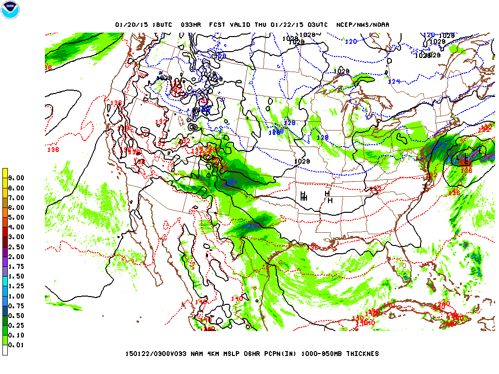
Saturday – lingering showers and maybe a thunderstorm or two in the morning, but it does not appear the entire day will be a washout. We’ll be in the warm sector which should allow for temperatures to approach 80 or slightly higher, depending on the cloud cover situation in the afternoon hours. Sadly, I know this is not what all you runners that are going to be doing the Brooklyn Half Marathon want to hear.
North American Model high resolution output for Saturday at 11AM, showing the possibility of showers.
Sunday – at this point, it appears Sunday will be dry, with more clouds than sun, and temperatures remaining warm in the upper-70s. A blocking high pressure center over the Gulf of Maine should be enough to prevent rain from entering the area.
Monday – the high pressure depicted above will retreat eastward a bit, which would allow for a better chance of rain later Monday evening/night into Tuesday. During the day, conditions should be dry with partly sunny skies and a high near 70.
A downright summer-like stretch of weather that started this week will get mirrored again towards the end of this week and going into next week. After clearing out clouds today, the remainder of this week should see dry and sunnier weather with highs in the mid-upper 70s. This weekend, we are looking at the possibility of temperatures near 80, nearly 15º above normal. We also have what could turn into the 2015 season’s first tropical depression/storm churning up off the coast of Florida now.
Rest of today – a very slow-moving, largely stationary front pushed through last night, but is still sitting in our vicinity. Along this front, remnants of more organized convective activity will be able to slide east during this afternoon and evening. While the chances are not high, there could still be an occasional shower during the latter half of today, high temperatures will be somewhat subdued around 70 with the clouds in place.
Thursday – clouds will clear out tomorrow and we should have a sunny day with temperatures in the mid-70s.
Friday – a repeat of Thursday, with mostly sunny skies and highs again in the mid-70s.
Saturday – increasing cloud cover, but should still be a pleasant day with temperatures in the upper 70s.
Sandwiched between rain to our south and to our west, but our weather should still remain dry this weekend.
Sunday – warm and pleasant with a high near 80.
Climate Prediction Center temperature outlook for next week – still looks like we’ll be getting warmer than normal temps
First Tropical System of the 2015 Atlantic Hurricane Season?
As I write this, a low pressure system is building up steadily off the east coast of Florida. The National Hurricane Center puts the odds of this system organizing sufficiently to become the first named tropical depression, subtropical, or tropical storm of the 2015 Atlantic Hurricane Season. Even if this storm does become the first named tropical system, it is unlikely to do much damage as it will have very little time over open water to gain strength before it is forecast to make landfall over the Carolinas later. The most noticeable impact from this storm would be the rain it generates.
Another messy start to the work week is in store for us tonight and into Monday night as we endure a long duration, though relatively light intensity winter storm. Luckily for us, the storm track means we’ll avoid the worst impacts of heavy snow (New England will get the worst of it again). There’s some concern for icing again, although the impact should be slightly less serious than last Monday. The rest of the week will be precipitation free, with the exception of some snow showers possible Thursday. Following these snow showers, another shot of brutally cold Arctic air is expected by week’s end, such that highs will only be in the low 20s and even upper teens.
Monday – as you can see from below, the snowfall totals for the southern portion of the NYC area are on the very low end, only 1-2″ expected in NYC and in Long Island. The higher snowfall totals will be north of I-84 and into Connecticut, with the far northern suburbs getting a chance at over 6″. Bear in mind, the snow is expected over an extended period starting tonight through Monday night.
Storm total snow forecast
Ice is a bigger concern for the immediate coastal areas that will see less snow. High temperatures during the day Monday be below freezing, so freezing rain is expected and could deposit between 0.15″-0.25″ of ice when all is said and done. The majority of this is expected to fall Monday morning before temperatures cool off at the coast and precipitation switches back to all snow.
Storm total ice forecast
Tuesday – high temperatures should be right around freezing with clouds diminishing through the day as the storm system from Monday pulls to the east.
Wednesday – a sunny day expected with highs again near freezing.
Thursday – we get our next chance at snow, on the light side, with a passing low pressure system forming over the Great Lakes and moving east towards us high temperatures will be again around freezing.
Friday – a sunny, but frigid day with highs expected to only be in the upper teens and low 20s. As you can see from the chart above, to the west of the low affecting our area on Thursday, there is an area of high pressure which will usher in that reinforcing blast of Arctic air.
The low overall snowfall totals for NYC yesterday wasn’t so much a problem as the significant icing that resulted from an extended period of freezing rain. Ironically, a week the city government took criticism for shutting down the transit system for blockbuster blizzard that did not come to pass here, it was 1/4″ coating of ice that wreaked havoc on the entire transit system (the hours long complete suspension of the 7 train was an extreme example of this). We do get a couple more shots at snow, once tomorrow night into Thursday, and then again during the weekend, but at this time neither event looks to be nearly as high impact as what we’ve experienced the last two weeks.
Wednesday – will be comparatively mild in the context of the rest of the week and the weather we’ve had recently. High temperatures may actually even hit 40 (slightly above normal). However, as a cold front approaches from the west, we’ll have an increasing chance for snow showers, which maybe mixed with rain at the coast during the earlier part of the evening.
Thursday – chance for snow showers continues along the vicinity of the frontal boundary as it passes over us. Following the passage of that cold front, temperatures take a serious drop as northwest winds allow for Arctic air to make a comeback into the area. Lows overnight Thursday could be as low as the single digits for the city and below zero for outlying suburbs. Coupled with a northwest wind of 15-20mph, this would produce dangerously cold wind chill values.
Generally low snowfall totals expected across the region from this event
Friday – high pressure builds in briefly for Friday, giving us the only guaranteed dry day through the forecast period. It will still be cold with highs only in the low 20s.
Saturday – an arctic front will be approaching during the day Saturday, and ahead of the front, we’ll actually about normal temperatures in the upper 30s due to southwest flow. Clouds build in and the chance for snow showers builds during the later part of the day into the overnight.
Sunday – the arctic front mentioned above moves over us but then it looks like it will stall in our vicinity for an extended period from Sunday into Monday. High temperatures will cool to around freezing in the wake of that frontal passage.
At this time, it’s too early to know exactly how much snow we would pick up. It does appear that the precipitation with this system will be generally on the lighter side, except as the low pressure center depicted over southern Illinois in the graphic below approaches the coast. Once it arrives just west of the coast, it could draw in some moisture off the ocean as the counterclockwise cyclonic flow around the eastern periphery of the low induces an extended period of onshore flow (like a sea breeze, except in this case, the air over the water is actually warmer than it is over the snowpack on the land). If this onshore flow is robust enough, it could warm coastal areas up enough to get some rain out of the storm.
Stationary arctic frontYou can see the distinct separation between warm and cold airmasses demarcated by the stationary front depicted in the image above – the front separates the areas with the blue dotted lines from the areas of the warm dotted lines.
We got a bit of a (cold) respite during the weekend from any precipitation, but all that is about to change in a big way tonight and into tomorrow. A complex storm system that is set to bring snow across a wide swath of the Midwest will be approaching the area tonight and into tomorrow. Various factors make this storm even harder to forecast than the Nor’easter last week, including a still uncertain storm track and a very tight temperature gradient leading to the potential for a mixed bag of all precipitation types in the NYC region.
Impacts
This storm is set to make Monday a downright nasty day to be out. Snow is forecast to begin falling tonight, with areas to the north of the city expected to pick up the most snow through this storm. During the AM rush, temperatures are expected to rise just enough in the lower atmosphere to allow for the possibility of sleet, ice pellets, and a period of freezing rain along the coast near the city, with rain possible further east in Long Island. Then, to close out the day, temperatures will drop rapidly below freezing, such that any slush or melted snow or wet surfaces could flash freeze. Because the temperature gradient is so tightly packed, it will again literally be a matter of miles between a spot that picks up mostly snow and perhaps 8″+, and another location that picks up almost no snow, but gets a significant coating of ice.
Ice accumulation forecast – anything over 0.10″ can cause serious problems.Snowfall total forecast – note the similarity with the last storm as to how dramatically snow totals range across a very small geographic area.
Below are some probabilistic forecast graphics that will give you a good sense of the degree of uncertainty within this storm forecast. First, with respect to snowfall totals over the next 48 hours.
Probabilities of greater than 2″ of snowProbabilities of snow accumulation greater than 4″Probabilities of greater than 8″ of snow
Here’s the same time window, but with probabilities for ice accumulation.
Probability of ice accumulation greater than .10″Probability of greater than .25″ of ice accumulation
In the snowfall probability maps, you can see just how tightly packed the different bands of probability for snowfall are. A matter of 50 miles means the difference between being in an area of 40%-50% probability of receiving more than 4″ of snow, and an area with a greater than 80% chance of receiving the same total.
Timing
Snow will begin to fall later this evening and pick up in intensity overnight. Depending on the area you’re living in, you could see between 3″-8″ overnight, with the highest totals most likely north of the city, and the lowest totals along the coast and in eastern Long Island. Around the morning rush, areas along the coast and eastern Long Island should begin to see a transition from snow to freezing rain, or some type of wintry mix of ice pellets and sleet. Some parts along the coast may even see a changeover from rain/snow to plain rain. In the afternoon, temperatures will drop quickly below freezing, allowing for flash freezing of slush and other wet surfaces. Winds will begin from the east initially before turning northeast and then north through the day.
Why the Uncertainty?
The reason behind the complexity of this storm with respect to precipitation types, uncertainty of total snowfall amounts, rests with storm’s track and the dynamics in the lower atmosphere accompanying this storm. This storm, unlike a Nor’easter, has its genesis over the Central Plains. However, as it approaches the coast, it will still be able to pick up a good amount of moisture off the ocean and from points south.
Recalling that air around a low pressure center in the northern hemisphere in a flows in a counterclockwise motion, you can better understand what is going on here. The low pressure center is forecast to pass just to our south. To the north of the storm center, colder air will dominate, since the cyclonic flow would be pulling air from north to south. Meanwhile, on the south side of the storm center, warmer air is being wrapped into the storm from the south and east. This onshore flow bringing relatively warmer air in close proximity to colder (sub-freezing) air is the reason why there is such a dramatic range in forecast snowfall totals across the area, and also the reason why there is a possibility for a range of different precipitation types.
Above is a forecast map that shows the forecast position and track of the storm. The colored points represent the individual forecast ensemble members (different forecast models with slightly different inputs) predictions for the storm. Notice that there is still a nontrivial spread between these ensemble members. You may also observe that they seem to cluster to the north of the official forecast track (the black line). Indeed, forecasters have been making slight northward adjustments in response to this trend. Should this bear out, and the low pressure center does move a bit further north, we would end up with less snow, more chance for mixed precipitation and even rain. On the opposite end, if the storm track deviates south, we would get more snow, and less chance for mixed precipitation. A very tricky forecast indeed!
A major nor’easter will be bringing a high impact blizzard throughout the NYC region tonight through Tuesday midday. Beginning this evening, snowfall will increase in coverage from south to north. Periods of heavy snow are expected with snowfall rates of 2-4″ per hour, with thundersnow occurring in the heaviest bands of snow. Extended periods of high winds, with sustained winds at least 35mph and gusts over 40mph (even up to 60mph) will lead to blowing and drifting snow, blizzard conditions, and near-zero visibility. Widespread snowfall totals of between 18″-24″ possible throughout the area, with locally higher amounts.
Snowfall Totals
Since yesterday afternoon, forecast models have backed off a bit on the overall total accumulations. At this point yesterday, the quantitative precipitation forecast (liquid water equivalent total) was as high as 2.7-2.8″ and broadly over 2.5″ across much of the area. As seen below, those liquid water equivalent numbers have gone down by about half an inch.
Liquid water equivalent forecast totals
This decrease in overall precipitable water has led to a corresponding downgrading of the overall snowfall totals. Using a 12:1 snow to water ratio, a drop in precipitable water by half an inch translates to a decrease in snow totals by 6″. Indeed, the National Weather Service has decreased the likely totals from 27″+ for many places to closer to 20-22″.
Snowfall accumulation total forecastHighest probabilities for snowfall totals in excess of 18″ during the 48 hour period ending 7AM Wednesday now rests over Southern New England, with the bullseye setting up right over Boston and immediate suburbs. Here in NYC, we are in the range of 30%-50% probability of receiving over 18″ – notice how abruptly the probability goes up as you go further north and east.
Timing
Light snow has already begun falling over the area, however the heaviest snow will not be occurring until after 8PM tonight. The most intense period of this storm is expected overnight tonight, as a deformation banding feature forms and begins moving slowly inland. Based on the simulated radar loop below from the NAM (North American Model), the peak intensity of snowfall looks like it will occur between 1AM-7AM overnight into Tuesday. Snow appears to taper off over NYC by 1PM tomorrow.
It does appear that a secondary set of banding snow will linger over eastern areas of the metro region throughout the afternoon Tuesday until as late as 4PM tomorrow.
By the way, part of the reason the main area of highest snowfall totals is now shifting to Southern New England and Boston is because it is anticipated that these areas will see moderate to heavy snow for much longer than we will here.
NAM model simulated radar output for this storm
Impacts
Snow, heavy at times, beginning in earnest this evening especially after 8PM. Some thundersnow possible, with the most intense snow occurring overnight. Strong sustained winds up to 35mph with gusts over 40mph and as high as 60mph will lead to blizzard conditions with blowing and drifting snow cutting visibilities down to near zero.
Caveats
Forecasters have been pointing out that there continues to be some slight disagreements between different models even though this storm is imminent. Snowfall total forecasts for storms like this one are notoriously difficult to predict with a high degree of accuracy prior to the event itself. This is due to the fact that the exact placement, movement, and intensity of the deformation banding feature on the northwest flank of the low pressure center is hard to foresee until the storm is ongoing. With snowfall rates as high as 2-4″ per hour within this banding feature, a difference of a couple hours under it could translate to 4-8″ difference in overall accumulation in any one location. Same thing with location, as one location that misses the most intense portion of the banding feature could easily miss out on 6″+ in total accumulation. Furthermore, a slight change in the thermal profiles within this type of storm could alter the snow to water ratio to be higher, and of course, a change from 12:1 to 15:1 would result in a dramatic difference in totals.
NYC gets brushed by a fast-moving Alberta Clipper system, with the potential for some light accumulating snow across the area Wednesday afternoon and evening. High pressure builds behind the clipper system Thursday and Friday, with high temperatures about average for this time of year. There’s some potential for a coastal storm approaching on Saturday/Saturday night, but with considerable uncertainty at this time, it remains to be seen if this scenario pans out, and if it results in snow or rain or a mix of wintry precipitation.
Wednesday – clouds increasing through the day with high temperatures in the mid-30s. Flurries may develop in the afternoon, however, the bulk of any snow is more likely to occur later in the evening and overnight. Max accumulations of 2″ in the city (1″ is more likely).
NAM model showing precipitation over the area Wednesday, as a clipper system transfers its energy over to a coastal low which will remain well offshore.
Thursday – mostly cloudy day with some snow flurries possibly lingering into the morning. High temperatures around the mid-30s.
Friday – high pressure continues to build over the region with skies clearing and high temperatures again in the mid-30s.
Saturday – forecast models are hinting at a coastal storm for Saturday. Right now, it appears as though the storm track brings the center of the low slightly to the east of the 40ºN 70ºW benchmark. Temperature profiles in the area also appear to be around the freezing mark. This will bear monitoring, as a slight westward jog of the storm track and a cooler temperature profile could result in some significant snow.
We end this week off with a windy day Friday, followed by an intrusion of cold air on Saturday before a warmup Sunday that should be accompanied by some rain during the day, then possibly a mix of rain and snow Sunday night. Some chance of snow persists into early Monday.
Friday – a cold front dropping from Canada will tighten the pressure gradient ahead of it, bringing with it breezy west-northwest winds between 15-25mph during the day tomorrow. High temperatures will be about normal in the upper 30s, but with wind chill values only in the 20s.
Saturday – subsequent to the passage of that cold front, we get another shot of cold, arctic air, with temperatures on Saturday struggling to even reach 30 in the city, and only in the 20s elsewhere.
Sunday – a low pressure system will be moving steadily northeast into Quebec by Sunday. This storm system will have a trailing cold front as well as a preceding warm front. We should enter the warm sector behind the warm front passing over us Sunday. This will allow for temperatures to rise into the mid-40s (possibly higher in a few spots). There will be a transfer of energy to a secondary low pressure center which is forecast to form off the Mid-Atlantic coast. This will result in the chance for us to get a few periods of moderate-heavy rain on Sunday, especially in the afternoon hours. As the coastal low moves off to the northeast, rain should taper down during the overnight hours into Monday, and temperatures will be cold enough to support a chance of rain/snow mix.
Monday – snow showers should end early Monday. High temperatures will be about average for this time of year, in the upper 30s.
We start this week with a mixed bag of precipitation, currently rain, but eventually back to a wintry mix before ending. The rest of the week will be dry, with colder days on tap for the mid-week period before another warming trend to end things off.
Tuesday – once the storm system that’s responsible for today’s rain and mixed precipitation moves away, a cold front will usher in a strong area of high pressure that will dominate our weather for the mid-week period. This high pressure area will allow cold Canadian air to flow into the area from the north. High temperatures will struggle to reach the freezing mark, while a steady north wind will ensure wind chills in the teens.
Wednesday – will be similar to Tuesday in terms of sensible weather with highs in the low 30s, and partly sunny skies.
Thursday – another partly sunny day, but with slightly warmer temperatures in the mid-upper 30s, near normal.
Friday – should be essentially the same as Thursday with highs again in the mid-upper 30s. Doesn’t look like we’ll get any chance for precipitation throughout the end of the week and weekend.
2015 is right around the corner, and I’m happy to report that weather conditions will be dry, though on the cold side for New Year’s Eve festivities and for New Year’s Day (we’re talking lows in the upper 20s in the city, daytime highs in the mid-30s). This cold but fair weather pattern holds through the week, with a slight warmup ahead of a storm system moving in Saturday & Sunday.
Tuesday – partly sunny day with highs in the upper 30s. However, north winds will yield wind chill values closer to 30.
Wednesday (New Year’s Eve) – with high pressure building to our west, and a low pressure system well to our north, things will stay dry and mostly sunny for your New Year’s Eve outings. The downside is that winds will remain moderate and push wind chill values into the 20s with daytime highs in the mid-30s. Overnight lows New Year’s Eve will be in the mid 20s, with wind chills in the teens.
Thursday – basically a repeat of Wednesday, with high temperatures hovering in the mid-30s and mostly sunny skies.
Friday – still cold, with highs in the upper 30s, though winds should abate slightly.
This weekend, we’ll see a storm system approach from the southwest and track to the Great Lakes region. The storm system should allow for some slightly warmer air to enter the region ahead of it, but we’re still only talking high temperatures only in the mid 40s. Best chance of rain will be Sunday.


