We have a week of below average cold to contend with before a warm up over the weekend. Two separate chances for snow will take place Tuesday, but neither of these events is expected to drop large snowfall totals.
Rest of today (MLK Jr Day) – cold with high temperatures in the upper-20s and increasing clouds.
Tuesday – temperatures at or just above freezing. Cloudy with a clipper system moving through and bringing chances for light snow accumulation of around an inch.
Wednesday – snow chances continue into the first part of the day as the clipper system transitions into a coastal low. Overall snow accumulation not expected to exceed 2″ at this time.
Thursday – mostly sunny with high temperatures just above freezing.
After a couple of warm days to start the week, temperatures cool off as a cold front moves through later this evening. A second frontal boundary passes through tomorrow, ushering even cooler, and dry weather for the remainder of the week. Another chance for rain is possible Saturday as a weak Alberta clipper system impacts the area.
Rest of today – mostly sunny with a high in the low-mid 80s. There is a possibility for scattered showers and thunderstorms especially inland later this afternoon between 3-5PM as a cold front approaches from the west. Some of these storms could produce damaging wind gusts and small hail, but these are unlikely to impact the city and coastal areas where the air mass is more stable due to the influence cool ocean waters.
High Resolution Rapid Refresh model output for today at 3:30PM
Wednesday – with the cold front having passed through, temperatures cool off into the low-70s. The day starts out sunny but clouds will increase ahead of another frontal boundary nears in the afternoon. Ahead of this boundary, a better chance for showers and thunderstorms develops, and once again there could be some widely scattered strong-marginally severe storms.
North American Model High Resolution simulated radar output for Wednesday at 11AM.
Thursday – temperatures will range in the 50s overnight into Thursday, leading to yet another day of below average, but comfortable temperatures in the low-70s with northwest wind driven by high pressure building to the southwest over the Mississippi Valley. This will pull in a drier, fall-like airmass from Canada.
Friday – slightly warmer with highs in the low-mid 70s, mostly sunny.
Saturday – there’s a chance for some scattered showers Saturday afternoon into the overnight hours as an Alberta clipper system approaches, otherwise, partly sunny with high temperatures in the mid-70s.
This week will feature below normal temperatures for the most part, with a chance at some snow showers for the first time this winter coming along with an Alberta clipper type system tomorrow afternoon into the overnight hours. Later on this week into the weekend, we are looking at a more potent and complex storm system that could bring a mix of precipitation to the area.
Rest of today – mostly sunny with scattered clouds and a high temperature in the mid-30s. A breezy day with west winds in the 15-20mph range.
Tuesday – partly sunny to start the day, with high temperatures hitting the upper-30s to about 40ºF. Snow flurries/rain could mix together in the afternoon. As temperatures drop after sunset, precipitation should transition to all snow. Due to the quick moving nature of this clipper system, we’re not really expecting any accumulating snow.
Wednesday – following the passage of the clipper system, winds pick up again from the west in the 15-20mph range, delivering a cold day with partly sunny skies and high temperatures right about freezing.
Thursday – slightly warmer, with high temperatures in the mid-30s, and a calmer wind so not as much of a biting cold.
NYC gets brushed by a fast-moving Alberta Clipper system, with the potential for some light accumulating snow across the area Wednesday afternoon and evening. High pressure builds behind the clipper system Thursday and Friday, with high temperatures about average for this time of year. There’s some potential for a coastal storm approaching on Saturday/Saturday night, but with considerable uncertainty at this time, it remains to be seen if this scenario pans out, and if it results in snow or rain or a mix of wintry precipitation.
Wednesday – clouds increasing through the day with high temperatures in the mid-30s. Flurries may develop in the afternoon, however, the bulk of any snow is more likely to occur later in the evening and overnight. Max accumulations of 2″ in the city (1″ is more likely).
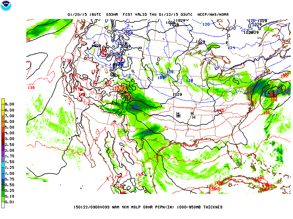
NAM model showing precipitation over the area Wednesday, as a clipper system transfers its energy over to a coastal low which will remain well offshore.
Thursday – mostly cloudy day with some snow flurries possibly lingering into the morning. High temperatures around the mid-30s.
Friday – high pressure continues to build over the region with skies clearing and high temperatures again in the mid-30s.
Saturday – forecast models are hinting at a coastal storm for Saturday. Right now, it appears as though the storm track brings the center of the low slightly to the east of the 40ºN 70ºW benchmark. Temperature profiles in the area also appear to be around the freezing mark. This will bear monitoring, as a slight westward jog of the storm track and a cooler temperature profile could result in some significant snow.


