After a cold start to the first full month of spring, we’re finally turning the corner and headed into a gradual warming trend to end the month. This week looks good, with mostly dry weather except for Tuesday, and temperatures at or slightly above normal in the upper-50s to around 60ºF.
Rest of today – skies have been clearing up the past few hours, though there are more clouds to our west. However, no rain is expected to fall until much later in the overnight hours and temperatures should be pleasant in the mid-50s.
Tuesday – rain in the morning, cloudy and warmer with high temperatures around 60ºF.
Wednesday – mostly sunny day with high temperatures again in the upper-50s to around 60ºF under the influence of a high pressure center.
Thursday – basically a copy of Wednesday, but perhaps a couple degrees warmer.
Friday – the streak of good weather continues, another nice day pretty much like Friday.
Warming Trend
Above normal temperatures are expected for almost the entire country, including the Northeast, for pretty much the remainder of the month.
Another day of near record or record breaking temperatures is on tap for the region as a highly anomalous stretch of warm weather continues. Yesterday, Central Park hit 77ºF, shattering the old record of 69ºF set in 2000 by nearly 10ºF. Looking ahead, temperatures will moderate somewhat over the weekend, but will remain 10ºF+ warmer than normal for this time of year in the upper-50s to low-60s. We spring forward an hour into Daylight Savings Time on Sunday.
Rest of today – temperatures at this hour were already well into the upper-60s and just over 70ºF across the region. Today would easily be warmer than yesterday if not for the fact that current satellite trends suggest that widespread cloud cover will be moving in over the next couple of hours. Areas that experience more breaks in cloud cover today could break some records. Rain will develop, first to the north, then push through the whole area overnight tonight.
Friday – clouds should clear up steadily through the day Friday. A cold front will move through, and will cause high temperatures to dip by about 10ºF compared to today, yielding highs in the low-60s, but that will still be over 10ºF above normal for this time of year.
Saturday – high pressure from the north takes control and gives us a beautiful, sunny day with high temperatures near 60ºF.
Sunday – similar temperatures to Saturday, but with increasing clouds as the next storm approaches the area.
Monday – cooler with high temperatures in the low-50s and rain.
Warm Trend Continues to Late March
Looking ahead, temperatures are forecast to continue at above normal levels through the majority of March.
This week opens up with some very mild and spring-like weather. March will arrive like a lamb for sure. However, following a storm system moving through Wednesday, temperatures will cool off to below normal levels, with a possibility for some snow Friday! This kind of highly variable weather is typical for spring, which officially starts in just under 3 weeks time.
Rest of today – a line of showers associated with a cold front passed through this morning and has moved well off to the east of the city. Skies have cleared up, and temperatures are rising steadily into the upper-50s. Would not be surprised to see some areas top 60ºF this afternoon.
Tuesday – despite the passage of a cold front today, temperatures don’t cool off too much tomorrow. Mostly sunny skies should yield temperatures slightly above normal in the upper-40s.
Wednesday – the next storm system moves in overnight Tuesday into Wednesday. The low pressure center responsible for this storm is forecast to pass almost directly over the region early Wednesday morning. As it approaches, it will pull in warmer air from the south into its counterclockwise cyclonic flow, which will result in temperatures actually warming up overnight into the upper-40s. Temperatures will peak Wednesday morning around 50ºF, accompanied by periods of rain. Rain should be dissipating by 2PM in the afternoon.
Thursday – following the passage of the low pressure above, temperatures will cool off into the upper-30s fro Thursday under mostly sunny skies.
Drought Ends
The last couple months have delivered sufficient snow and rain to bust the moderate drought that had been persisting over the NYC metro area, in particular on Long Island. This is excellent news for farmers and gardeners throughout the region ahead of the upcoming growing season.
This upcoming week will feature some big swings in temperature, with high temperatures increasing steadily up through Thursday, when highs could 60 before a cold front swings through. Following the passage of this cold front, we dip back into the mid-40s and continue cooling into the lower-40s this weekend. The temperature trend in the medium term remains below normal, potentially well below normal even through the first week of April, as a series of cold fronts continue to allow cold Canadian air to enter the area.
Monday – an area of high pressure will yield a sparkling sunny day, but will also permit cold, Arctic air back into the region. Northwest winds combined with noticeably cold overnight lows will produce uncomfortably cold conditions. High temperatures Monday may barely break freezing. It’ll be one of the coldest day we’ve had this month.
Tuesday – also gets off to a chilly start, but high temperatures are expected to push up to around 40 (which is more than 10ºF colder than normal).
Wednesday – a clear start, but clouds will be building ahead of a warm front that will pass over the region late Wednesday. Temperatures will steadily climb to near 50, especially after the warm front passes. There will be a slight chance for rain later Wednesday in conjunction with this frontal passage.
Thursday – highs will near if not break 60, however, it is anticipated to be a overcast day with periods of rain possible throughout the day. After the warm front passes Wednesday, we’ll be firmly within the warm sector, between the warm front to our east and the approaching cold front from the west. This setup favors the influx of warm, moist air from the Gulf riding in on persistent southwesterly winds, before a dramatic shift following the cold front passing, with winds becoming west-northwest and a drop in temperatures.
Friday – high temperatures drop back in to the mid-40s, as clouds break apart and colder, dry air takes hold behind the cold front.
Below Normal Start to April
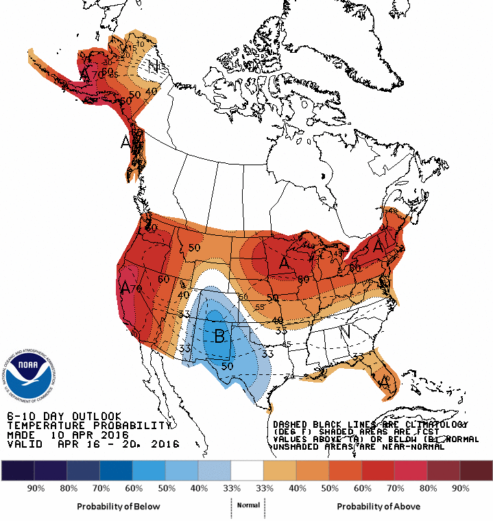
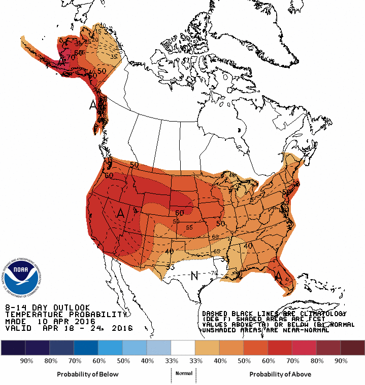
It’s close to a sure bet (70% probability) that we’ll end the month of March and start April with below normal temperatures, taking a look at the Climate Prediction Centers forecasts below. I know we’re all sick of this seemingly endless winter, but we’re still not out of the woods in terms of temperatures.
6-10 temperature outlook from the Climate Prediction Center8-14 temperature outlook from the Climate Prediction Center
Just when we thought winter was on its last legs, and spring was on its way. Unfortunately, as the Climate Prediction Center forecast a couple weeks ago, a cool down is in the cards to end the month of March. In fact, it will get so cold that snow could accumulate Friday into Friday night. After a brief warmup, another shot of colder than normal air will return to grip the area to end off the month.
Thursday – a below normal, but dry day with plenty of sun and high near 40.
Friday – (ironically, first day of astronomical spring) a coastal low moving offshore of the Carolinas will then track north. Enough cold air will be in place Friday, along with a persistent northerly flow with counterclockwise circulation around the low pressure center that snow is looking likely during the course of the day. Current forecast snow accumulations are on the light side, no more than 3-4″. If temperatures are even a few degrees warmer than currently forecast, we could get away with little accumulation.
Friday’s storm
Saturday – things clear up quickly on Saturday with high temperatures back near normal in the mid-upper 40s.
Sunday – a dry cold front moves through Sunday, leading to a drop in temperatures to below normal in the upper 30s.
Cool Off Coming Up
The climate prediction center continues to point to cooler than normal temperatures for the last two weeks of March. One can only hope that the temperatures are not so cold as to allow for more snow, but I wouldn’t rule this possibility entirely out given some of the longer term forecast models.
6-10 temperature outlook8-14 day temperature outlook
Today may be the last major winter storm of the winter for us. It certainly has been an eventful and cold winter for the books. We’ll end the week and start off this weekend and early next week with below normal temperatures, but temperatures will rise steadily throughout next week, such that we should be back to normal temperatures in the mid-upper 40s by the end of next week.
Rest of today – snow is already tapering off over the area, with widespread snowfall totals of between 4-8″ reported (largely in line with forecasts). Any remaining precipitation should completely clear the area within the next couple of hours.
Friday – we endure what we all hope will be the last day of temperatures in the low-mid 20s as cold, dry air filters in behind this storm system.
Saturday – high pressure moves in over the weekend, with temperatures Saturday edging up to around freezing.
Sunday – fair weather continues, but perhaps with more clouds on Sunday as some weak impulses of energy move over areas well to the north of NYC. High temperatures will increase to the low 40s.
Monday – the warming trend continues as spring approaches, high temperatures continue to warm into the mid-40s under partly cloudy skies.
Finally leaving the Arctic air behind?
A large scale warming trend is forecast to take hold over much of the US during the medium term. Temperatures next week should warm progressively such that by next Friday, we’ll be looking at (gasp) high temperatures near 50. The week after, on the cusp of spring, almost the entirety of the Continental US is forecast to experience warmer than normal temperatures, with the exception of Texas, and New York into Southern New England. However, we are forecast to be in normal range of temperatures for this time of year, which means mid-upper 40s. Not quite flip flops and t-shirt weather, but a positive trend nonetheless.
It’s been a wild weather week that started with a tornado outbreak across half a dozen states in the South, and torrential rain fall that dropped as much as 2 feet in Florida, and as much as 6-8″ across the Northeast (resulting in incredible scenes like this landslide in Baltimore).
Fortunately, the weather has taken a turn for the better and will remain that way much of the coming week. This weekend is shaping up to be a nice one with temperatures on Saturday and Sunday reaching into the upper 60s to the low 70s across the region. There is a chance on both days of popup showers or thunderstorms in the afternoon, especially in inland areas with better daytime heating.
GFS model upper air (500mb absolute vorticity) output for this coming Wednesday. Note the strong trough out west (dip in the contour lines), and a ridge over our region (bulge towards the north of contour lines). Ridges correspond with high pressure and good weather while troughs denote low pressure and poor weather.
We’re finally turning the corner on warmer spring temperatures as the start to next week Monday-Wednesday will continue to feature high temperatures consistently in the low-mid 60s (about average). Dry and mostly sunny skies should also predominate as a ridge of high pressure (see above) builds in over our region.
Sunny skies are your headline for weather this weekend. After what’s been a rudely cold interruption to spring, we’re returning to more seasonable temperatures and a calm weather pattern.
High pressure will dominate the area Saturday leading to sunny conditions with temperatures rising into the mid-upper 60s.
Sunday – high temperatures will be somewhat inhibited by onshore winds off the ocean as the high pressure center moves to our northeast and winds turn to the northeast and east.
Monday – the streak of pleasant weather continues after a cold start to the morning with highs again reaching the low 60s under sunny skies.
Next chance of precipitation will be Tuesday with a weak low pressure system and cold front moving in from the Great Lakes.
Don’t be fooled by this gorgeous weather today (seriously).
A low pressure system forming in the lee of the Rockies, along with a nearly stationary frontal boundary draping down from a low moving into Canada will result in cloudy to mostly cloudy skies for the remainder of the week. There will be a chance for rain each day through Friday. The best chance for steadier rain will be late in the day Friday through Friday night and perhaps into early Saturday morning. This is associated with another area of surface low pressure and trailing cold front.
Note the frontal boundary draping across the region – this will give us a chance for showers each day Wednesday-Friday.
High temperatures will warm to near 60 Wednesday with a persistent south-southwesterly flow ahead of the aforementioned frontal boundary.
Thursday – with the influence of clouds and possible showery rain, temperatures will most likely hover around the mid 50s.
Friday – rain increasingly likely throughout the day Friday with high temperatures continuing to drop to around 50.
Saturday – temperatures will warm again into the upper 50s ahead of a cold front (and with a warm front forecast to swing through), however, it will be a cloudy day with a diminishing chance of showers through the day.
Sunday – the cold front will have passed through allowing for skies to clear, but temperatures will be cooler in the low 50s with winds from the northwest.
Next shot at precipitation comes Monday night into Tuesday with a surface low tracking from the Southeastern US.
A very brief update to let you all know the storm will miss us well to the southeast. This will limit snowfall totals to less than 2″ in most areas of the NYC region tonight into Wednesday, with the possible exception of far eastern Long Island.
Thereafter, expecting a general warming trend through the end of the week. Temps will top out in the upper 50s to around 60 by the weekend, when the next frontal system approaches from our west (no more snow, thank God). More detailed forecast to come.


