This week begins with weather more indicative of May, with warm temperatures in the upper-70s today and around 70ºF tomorrow before temperatures cool off a bit later in the week. Pleasant conditions all week as it seems spring has finally taken hold for good.
Rest of today – warm, with clear skies and high temperatures well above normal (by around 15ºF) near 80ºF in the city. Cooler along the south-facing shores of Long Island and warmer inland over New Jersey.
Tuesday – a cold front will pass through from the north overnight into Tuesday, but is not expected to bring any rain with it. This will result in cooler temperatures on Tuesday, with high temperatures peaking around 70ºF.
Wednesday – a bit cooler with temperatures peaking around 60ºF with clear skies.
Thursday – increasing clouds with the next storm system approaching late in the week, temperatures will warm up into the mid-60s ahead of this storm.
After a cold start to the first full month of spring, we’re finally turning the corner and headed into a gradual warming trend to end the month. This week looks good, with mostly dry weather except for Tuesday, and temperatures at or slightly above normal in the upper-50s to around 60ºF.
Rest of today – skies have been clearing up the past few hours, though there are more clouds to our west. However, no rain is expected to fall until much later in the overnight hours and temperatures should be pleasant in the mid-50s.
Tuesday – rain in the morning, cloudy and warmer with high temperatures around 60ºF.
Wednesday – mostly sunny day with high temperatures again in the upper-50s to around 60ºF under the influence of a high pressure center.
Thursday – basically a copy of Wednesday, but perhaps a couple degrees warmer.
Friday – the streak of good weather continues, another nice day pretty much like Friday.
Warming Trend
Above normal temperatures are expected for almost the entire country, including the Northeast, for pretty much the remainder of the month.
Although spring is still technically two weeks away, it certainly will not feel that way this week with some very warm weather coming our way. The warm temperatures appear to persist well into the latter part of this week, and onwards into the weekend.
Rest of today – a sunny preview of things to come this week with temperatures in the mid-50s.
Tuesday – the warm up begins with high temperatures easily reaching 60ºF in the city despite clouds.
Wednesday – as high pressure moves off of the East Coast, clockwise return flow on its western edge brings with it a surge of warmer air, allowing temperatures to soar into the upper-60s (probably topping 70ºF in the city also), breaking some daily records especially in interior regions.
Thursday – a weak disturbance moves through late in the day on Thursday, but temperatures will remain warm in the upper-60s prior to this disturbance’s passage.
Friday – following the passage of the disturbance above, we get somewhat of a cool down, with high temperatures dropping 10ºF into the upper-50s on Friday. This is still well above normal for this time of year though!
Spring Warms Up Early
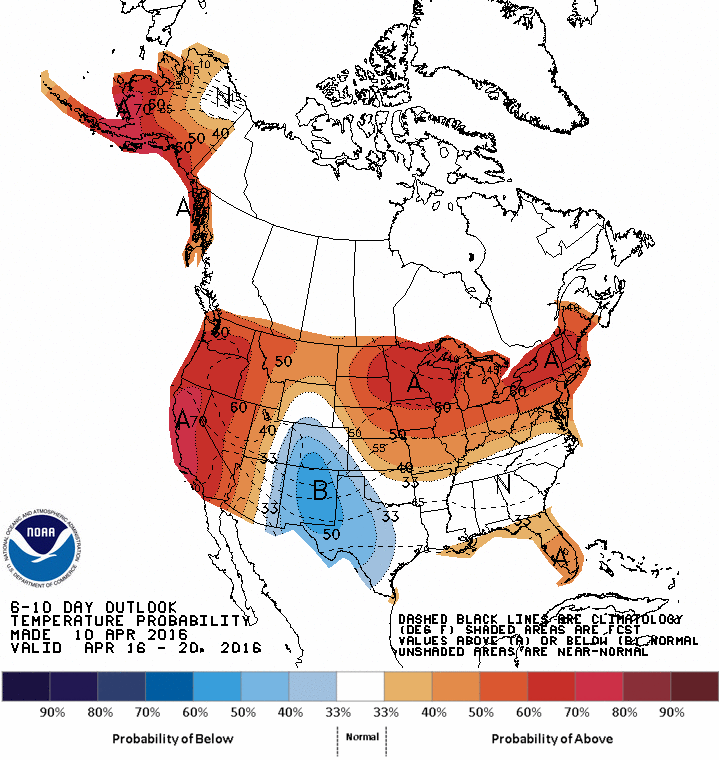
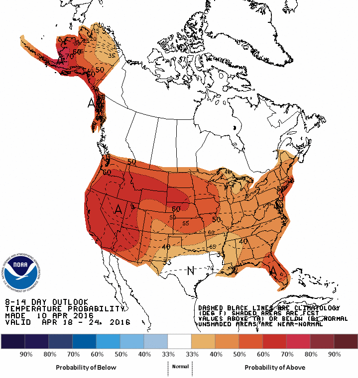
Looking ahead, Climate Prediction Center models suggest a high likelihood of above average temperatures for the entire Eastern United States in the 1-2 week range.
This upcoming week will feature some big swings in temperature, with high temperatures increasing steadily up through Thursday, when highs could 60 before a cold front swings through. Following the passage of this cold front, we dip back into the mid-40s and continue cooling into the lower-40s this weekend. The temperature trend in the medium term remains below normal, potentially well below normal even through the first week of April, as a series of cold fronts continue to allow cold Canadian air to enter the area.
Monday – an area of high pressure will yield a sparkling sunny day, but will also permit cold, Arctic air back into the region. Northwest winds combined with noticeably cold overnight lows will produce uncomfortably cold conditions. High temperatures Monday may barely break freezing. It’ll be one of the coldest day we’ve had this month.
Tuesday – also gets off to a chilly start, but high temperatures are expected to push up to around 40 (which is more than 10ºF colder than normal).
Wednesday – a clear start, but clouds will be building ahead of a warm front that will pass over the region late Wednesday. Temperatures will steadily climb to near 50, especially after the warm front passes. There will be a slight chance for rain later Wednesday in conjunction with this frontal passage.
Thursday – highs will near if not break 60, however, it is anticipated to be a overcast day with periods of rain possible throughout the day. After the warm front passes Wednesday, we’ll be firmly within the warm sector, between the warm front to our east and the approaching cold front from the west. This setup favors the influx of warm, moist air from the Gulf riding in on persistent southwesterly winds, before a dramatic shift following the cold front passing, with winds becoming west-northwest and a drop in temperatures.
Friday – high temperatures drop back in to the mid-40s, as clouds break apart and colder, dry air takes hold behind the cold front.
Below Normal Start to April
It’s close to a sure bet (70% probability) that we’ll end the month of March and start April with below normal temperatures, taking a look at the Climate Prediction Centers forecasts below. I know we’re all sick of this seemingly endless winter, but we’re still not out of the woods in terms of temperatures.
6-10 temperature outlook from the Climate Prediction Center8-14 temperature outlook from the Climate Prediction Center


