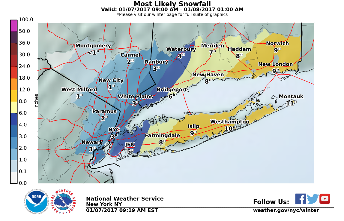
Tag Archives: winter storm

NYC Nor’easter Snowstorm – Jan 28-29, 2022

Synopsis

A major winter storm is expected to hit the Northeast primarily Saturday with a strong nor’easter developing and deepening as it tracks offshore. This will bring a swath of > 8″ accumulations from NYC through points north and east, with the bullseye likely over southern New England where snowfall totals could exceed 2 feet locally. Gusty north winds will accompany this storm, leading to some blowing and drifting snow. In line with most other forecasts this morning, my own forecast is for 7-10″ of snowfall in NYC but with the potential for a sharp gradient possibly cutting through the city itself, where the western part of the city could see below 6″ while eastern sections see closer to 10″ or more.

As with the last round of accumulating snow we had, antecedent conditions support enough cold air in place to result in an all snow event. With a storm track offshore enough so there should be no mixing, the primary uncertainty in snow totals arises from storm track. Model runs today should help us determine if the storm will track on/near the 40ºN 70ºW benchmark (more snow), or to the east (less snow). Overnight, model consensus has shifted west, supporting higher snow totals than were forecast at this time yesterday. If we see some consistency across runs today supporting this solution, confidence will grow in a significant snowfall for NYC. Mesoscale banding will bring bouts of intense snow with this storm, and the exact placement / duration of these features will determine where the highest snow totals occur.

Forecast Details

At the Surface

Models are projecting a couple shortwaves merging and developing as a coastal low off of the Carolinas later today and tonight. This storm is forecast to intensify and track a little east of the 40ºN 70ºW benchmark overnight, a position that historically signals the best snowmaking potential for NYC during coastal winter storms. The forward speed of this storm has picked up in model runs recently, but it is expected to be a strong storm with minimum pressures falling to the 960s by Sunday. A tight pressure gradient is expected between the intensifying low and high pressure to the north, which should cause gusty north winds to help advect cold air down to the coast.

850 mb – 700 mb Level

A robust 850 mb low-level jet flowing onshore from the northeast is forecast. This should provide the storm with good moisture content, aiding the formation of snow. Strong 850 mb and 700 mb temperature advection and frontogenesis is also evident in all models, occuring during the morning Saturday. This should induce heavy snow bands to develop for a few hours early on Saturday. These bands could produce 1-3″ per hour snowfall rates, and as always, areas where these bands set up and persist the longest will ultimately pick up the higher end totals.

500 mb Level

This storm will benefit from a deep, synoptic scale trough that will acquire a slight negative tilt. This trough will eventually form a closed low at this level. This will aid the low in intensifying by increasing divergence at this level, facilitating upward movement of air over the surface low, leading to lower surface pressures.

300 mb Level

The storm’s center is expected to lie downstream of an exit region of a jet streak, and also upstream of an entrance region of another jet streak to its north. This is ideal placement for maximizing divergence at this level of the atmosphere over/near the low’s center, and supports the development of a strong surface low.

NYC Weather Update – Dec 14, 2020

A quick hitting storm passes south of the city today bringing some rain and mixed precipitation, with no accumulating snow expected. Colder temperatures then take hold in the mid-30s behind this storm Tuesday as a strong area of high pressure builds over Quebec. This sets the stage for a potentially significant snowstorm developing Wednesday into Thursday with 8″+ totals possible along the I-95 corridor (with higher amounts north and west). However, there is still a good deal of uncertainty with the eventual track of this storm that could result in large differences in outcomes.

Rest of today – temperatures dropping through the low-40s into the 30s with mostly cloudy skies and a steady, chilly rain, possibly mixing with some wintry precipitation. No accumulation is expected. Overnight lows around the freezing mark with precipitation ending as high pressure begins building in.

Weather Prediction Center surface forecast for 1PM Monday. An area of low pressure is seen exiting the east coast, bringing us a period of rain and possible mixed precipitation, with snow further inland.

Tuesday – proverbial calm before the storm as high pressure dominates, giving us a mostly sunny day with high temperatures around 40ºF. Overnight lows again in the upper-20s with cold northerly winds flowing around the east side of this high.

Wednesday – high pressure yields to a developing coastal storm. Partly sunny to start with increasing clouds. High temperatures in the mid-30s. Overnight lows drop into the mid-20s. The big story is the potential for a significant snowstorm with accumulations possibly over 8″. GFS and the Euro model have come into agreement for much higher totals, 14-15″. However, NAM shows a warmer scenario with warmer air working further north, thus cutting into overall totals (only 7″). It’s also possible that the low tracks close enough to shore that we end up with a good deal of rain mixing in at the coast, cutting snow totals even further.

Part of the energy fueling this storm is coming all the way from a shortwave with origins over the Pacific Ocean. This has only just made landfall in the US today. As this energy gets sampled by upstream soundings (weather balloon launches) and other means, the forecast models should get a better sense for how this storm will evolve. At this time, there’s enough uncertainty in the forecast to still not buy into any specific totals. If you look below, you can see there’s a lot of spread in the models in terms of the track of this storm. This then translates to a wide range in ensemble forecast totals. In addition, with a coastal storm like this, where there’s a lack of deep, Arctic cold air ahead of the storm, there’s a sharp gradient between areas where the event would be all snow vs. a mixed event. If you see the 24 hour probabilities of > 8″ accumulation, you can see that a 50 mile shift in the storm track further south and east would give us much higher chances for big snowfall totals, while a shift the other way could result in a bust on snow totals. Suffice to say, this storm will bear close monitoring today and tomorrow as more data comes in and models have a chance to digest it.

Thursday depending on the speed and track of the storm, we could see precipitation lingering into the morning hours, with additional accumulation possible. Highs should hover around the freezing mark. Overnight lows drop into the mid-20s with reinforcing cold air advection on the backside of the departing storm.

NYC Blizzard Update – Mar 13, 2017

Classic major nor’easter to bring blizzard conditions to a large swath of the Northeast Tuesday just days from the official start of spring. Areas in and around NYC likely to see snowfall accumulations of over 1 foot, locally higher. This may end up being one of the biggest snowstorms/blizzards in history for the month of March in NYC.

Rest of today – the proverbial calm before the storm. Mostly sunny, cold, with high temperatures in the low-30s.

Tuesday – a major late season nor’easter will bring heavy snow and blizzard conditions to the area. Blizzard warning in effect for the entirety of Tuesday. Snow starts falling overnight into Tuesday. Heaviest snows forecast to begin around the morning rush and continue through most of the day. Blizzard conditions expected on the coast with steady north to northeast winds 30-35mph and gusts over 45mph. Visibility near zero at times. High temperatures at or below freezing. Widespread accumulations over 1 foot and approaching or exceeding 18″ expected around the NYC metro area. Details on the storm at the end of this post.

Wednesday – lingering chance for snow showers early with wrap around moisture on the backside of the departing nor’easter. Mostly cloudy with a high near freezing.

Thursday – skies clearing, high temperatures in the low-mid 30s.


Major Blizzard to Impact the NYC Region

Winter Storm Stella, as the Weather Channel refers to it, is set to bring widespread heavy snow to the area beginning overnight Monday and continuing throughout the day Tuesday.

Impacts – Snow accumulations over 1 foot, in many cases approaching 18″. Locally higher amounts, with some areas possibly approaching 2 feet. Heavy snow and blowing snow during the day Tuesday. Snowfall rates 2-4″ per hour and possibly higher in the heaviest snow bands possible. Thundersnow may accompany the strongest snow bands. Blowing and drifting snow with steady northeast winds 30-35mph and gusts 45-50mph will contribute to blizzard conditions with near zero visibility at times. East and northeast facing shorelines may experience moderate coastal flooding during high tide cycles. Heavy, wet snow at the coast combined with high winds may lead to power outages. Hazardous travel conditions, severe disruptions to aviation likely. High confidence in storm total snowfall at this point, but there is still uncertainty about whether and where mixing could occur.

Timing – Snow begins early in the overnight hours Tuesday. Light accumulations of 2-4″ possible by daybreak. Heavy snow likely beginning during the morning rush hour and continuing through most of the work day, as well as into the evening rush hour. Winds quickly intensifying from the morning and staying steady through the evening hours. Heaviest snow tapers off in the early evening hours, but snow showers could continue overnight. Winds remain strong overnight into Wednesday. Conditions improve going into the morning Wednesday.

Discussion – an area of low pressure that had its origins in the Pacific has made its way across the northern US, impacting the Northern Plains and Upper Midwest with snow. This storm system will phase with a secondary, coastal low pressure system that is currently moving up the coast from the Southeast. As these storms merge, the coastal low will undergo rapid intensification and cyclogenesis, becoming a strong Nor’easter. This storm will be drawing on subtropical moisture, and will encounter an airmass that will be quite cold due to the presence of an Arctic high pressure system prior to the storm’s passage. These ingredients will set the stage for a classic major blizzard for the Northeast late in the winter season, only days from spring.

As always, uncertainty remains about the exact location of the heaviest snow bands with this storm. Areas that are impacted by these bands can easily rack up several more inches than surrounding areas that are spared. The storm is expected to track west of the 40°N/70°W benchmark. However, during the last model runs, the storm track has trended north and west, increasing the chances for the city itself to see the heaviest snow, in addition to areas north and west. If this track shifts west some more, warmer air off the ocean wrapping into the core of the storm from the south could induce mixed precipitation with rain cutting down on totals in the city and Long Island. If the track shifts east, heavier snow would fall over points east of the city.

NYC Snowstorm Update – Feb 08, 2017

We’re in for a wild ride over the course of the next 24 hours as our weather goes from possibly record-breaking warmth to what is expected to be the most significant winter storm so far this season. Significant snow accumulations over 6″ and possibly as much as a foot are expected across the region, resulting in a winter storm warning for all of the NYC metro region.


Timing

Judging by the amount of sun we’re getting, temperatures will likely hit record-breaking levels in the low-60s in the city today. They will drop steadily to around 50ºF by the evening commute as a cold front pushes through and Arctic air flows in from the north. Overnight, temperatures will continue falling rapidly to around freezing. Precipitation is expected to begin around 3-4AM Thursday here in the city and continue through the early afternoon. Unfortunately, the timing of the heaviest precipitation does look to bring significant impacts to the morning commute.

North American High Resolution simulated radar 1km resolution, tomorrow at 8AM.


Impacts

Rain/snow mix to start, but by the morning rush, expecting all snow through the region. Heavy snow at times possibly reaching 1-2″/hr. Some thundersnow could occur. Hazardous travel conditions during the morning rush as plows will have trouble keeping roads clear with traffic and the moderate to heavy snow. Gusty winds could produce near-blizzard conditions with low visibility.


Snowfall Totals

Here are some graphics for snowfall totals from our local National Weather Service Forecast office. The general forecast calls for 6″-12″ in the city. The exact extent of totals will depend, as is generally the case with this type of storm, on where the heaviest snow bands set up and for how long they sit over an any given area.

Probabilities for 4″+ and 6″+ of snow respectively


Discussion

An shortwave that’s made its way rapidly across the country from the Pacific will move along the cold front that is pushing through today. As it does so, it will spawn a secondary low off the Mid-Atlantic that will strengthen rapidly as it moves over open water. At the same time, plenty of cold air will wrap around the deepening coastal low with high pressure to the west. This will put in place all the ingredients for a classic coastal winter storm for this area. The only thing keeping this storm from being a major blizzard with snowfall totals exceeding 2 feet is the fairly quick pace that it’s expected to move at.

This coastal storm will drive the expected heavy snows tomorrow. Its track is expected to take it just outside the 40ºN 70ºW benchmark, a spot that from a climatological perspective has translated to heavy snow storms for this region.


NYC Nor’easter/Winter Storm Update – Jan 7, 2017

Overnight, forecast models shifted the track of the ongoing Nor’easter further west. This has implications for snowfall totals across the region.

Snowfall Totals

These have been bumped up for the city, which is now expected to receive 2-5″. The potential exists for more. Winter storm warnings now extend as far west as Nassau County, with points further east receiving as much as 7-12″.

snowamt10prcntl
stormtotalsnowweb1

snowamt90prcntl

As always with Nor’easters, even as they are ongoing, considerable uncertainty remains a factor. With these storms, one or more banding features will develop and circulate around the center of the storm as it progresses northeast. The number, extent, intensity, and western limit of advancement of these banding features ultimately determines what areas get the most snow. Within these bands, snowfall rates could easily reach 1-2″/hour. West of the western limit of the progression of these bands, snowfall totals will drop precipitously, such that a distance of 10 miles could mean the difference between 2″ and 6″+.

Timing

You can already see the radar signatures of two bands of moderate to heavy snow spawned by this storm. One of these bands is currently pushing its way west through Long Island, while another progresses towards shore. Within these bands, travel conditions will rapidly deteriorate while accumulations rack up.

asdf

Looking ahead to this afternoon, it would appear that the heaviest snow will fall in the city around 2PM, or the early afternoon.

screenshot-from-2017-01-07-11-07-52

NYC Weekend Weather – Mar 17, 2016

Meteorologically, March is a month of highly changeable weather that can swing from one extreme to another. Thus far this month, we’ve seen snow, and record warm temperatures near 80ºF. This week is no different, and it ends with the possibility for a significant coastal storm that could bring accumulating snow to the region to ring in the official start of spring!

Rest of today – warm, with partly sunny skies and high temperatures in the mid-60s. An unstable atmosphere looks primed to spawn a few scattered thunderstorms. Atmospheric dynamics are supportive of strong wind gusts and possibly small hail with any storms that form this afternoon. Some of these storms could approach severe limits. Based on the latest High Resolution Rapid Refresh model output, there look to be two batches of storms, one impacting the region around 2PM, then again around 5:30PM. At the time of this post, two storm cells were moving slowly east over southern Bergen County and the western Bronx respectively.

Screen Shot 2016-03-17 at 12.39.22 PM

Friday – temperatures cool off into the low-mid 50s tomorrow, with a slight chance again for some afternoon showers, though nothing quite as significant as today.

Saturday – an area of polar high pressure will move over southeastern Canada, setting the stage for the winter storm Sunday. Saturday, however, will be a pleasant, sunny day, but temperatures will be below average in the low-mid 40s.

Sunday – all eyes turn to a developing coastal storm/Nor’easter. Forecast models are having a rough time handling this storm, with wide variances noted among some of the models from day to day. Given the uncertainty at this time, only a couple days before the expected onset of the storm, it is difficult to guess at the snowfall accumulations from this storm. One thing that is well understood at this point is that temperature profiles will support a primarily snow event, with some rain mixing in at the coast. High temperatures Sunday will struggle to hit 40ºF. Snow should begin in the morning, mixing with rain in the afternoon Sunday afternoon before transitioning again to all snow overnight. A slight variation in the forecast storm track either west or east could result in dramatically different snowfall totals – more updates to come.

Screen Shot 2016-03-17 at 12.40.16 PM

Monday – temperatures rebound back into the mid-40s under partly sunny skies following the passage of this late season snow storm.


NYC Weather – Another Complex Winter Storm – Feb 1, 2015

We got a bit of a (cold) respite during the weekend from any precipitation, but all that is about to change in a big way tonight and into tomorrow. A complex storm system that is set to bring snow across a wide swath of the Midwest will be approaching the area tonight and into tomorrow. Various factors make this storm even harder to forecast than the Nor’easter last week, including a still uncertain storm track and a very tight temperature gradient leading to the potential for a mixed bag of all precipitation types in the NYC region.

Impacts

This storm is set to make Monday a downright nasty day to be out. Snow is forecast to begin falling tonight, with areas to the north of the city expected to pick up the most snow through this storm. During the AM rush, temperatures are expected to rise just enough in the lower atmosphere to allow for the possibility of sleet, ice pellets, and a period of freezing rain along the coast near the city, with rain possible further east in Long Island. Then, to close out the day, temperatures will drop rapidly below freezing, such that any slush or melted snow or wet surfaces could flash freeze. Because the temperature gradient is so tightly packed, it will again literally be a matter of miles between a spot that picks up mostly snow and perhaps 8″+, and another location that picks up almost no snow, but gets a significant coating of ice.

Ice accumulation forecast - anything over 0.10" can cause serious problems.
Ice accumulation forecast – anything over 0.10″ can cause serious problems.

Snowfall total forecast - note the similarity with the last storm as to how dramatically snow totals range across a very small geographic area.
Snowfall total forecast – note the similarity with the last storm as to how dramatically snow totals range across a very small geographic area.

Below are some probabilistic forecast graphics that will give you a good sense of the degree of uncertainty within this storm forecast. First, with respect to snowfall totals over the next 48 hours.

Probabilities of greater than 2" of snow
Probabilities of greater than 2″ of snow

Probabilities of snow accumulation greater than 2"
Probabilities of snow accumulation greater than 4″

Probabilities of greater than 8" of snow
Probabilities of greater than 8″ of snow

Here’s the same time window, but with probabilities for ice accumulation.

Probability of ice accumulation greater than .10"
Probability of ice accumulation greater than .10″

Probability of greater than .25" of ice accumulation
Probability of greater than .25″ of ice accumulation

In the snowfall probability maps, you can see just how tightly packed the different bands of probability for snowfall are. A matter of 50 miles means the difference between being in an area of 40%-50% probability of receiving more than 4″ of snow, and an area with a greater than 80% chance of receiving the same total.

Timing

Snow will begin to fall later this evening and pick up in intensity overnight. Depending on the area you’re living in, you could see between 3″-8″ overnight, with the highest totals most likely north of the city, and the lowest totals along the coast and in eastern Long Island. Around the morning rush, areas along the coast and eastern Long Island should begin to see a transition from snow to freezing rain, or some type of wintry mix of ice pellets and sleet. Some parts along the coast may even see a changeover from rain/snow to plain rain. In the afternoon, temperatures will drop quickly below freezing, allowing for flash freezing of slush and other wet surfaces. Winds will begin from the east initially before turning northeast and then north through the day.

Why the Uncertainty?

The reason behind the complexity of this storm with respect to precipitation types, uncertainty of total snowfall amounts, rests with storm’s track and the dynamics in the lower atmosphere accompanying this storm. This storm, unlike a Nor’easter, has its genesis over the Central Plains. However, as it approaches the coast, it will still be able to pick up a good amount of moisture off the ocean and from points south.

output_QdaBc3

Recalling that air around a low pressure center in the northern hemisphere in a flows in a counterclockwise motion, you can better understand what is going on here. The low pressure center is forecast to pass just to our south. To the north of the storm center, colder air will dominate, since the cyclonic flow would be pulling air from north to south. Meanwhile, on the south side of the storm center, warmer air is being wrapped into the storm from the south and east. This onshore flow bringing relatively warmer air in close proximity to colder (sub-freezing) air is the reason why there is such a dramatic range in forecast snowfall totals across the area, and also the reason why there is a possibility for a range of different precipitation types.

lowtrack_ensembles

Above is a forecast map that shows the forecast position and track of the storm. The colored points represent the individual forecast ensemble members (different forecast models with slightly different inputs) predictions for the storm. Notice that there is still a nontrivial spread between these ensemble members. You may also observe that they seem to cluster to the north of the official forecast track (the black line). Indeed, forecasters have been making slight northward adjustments in response to this trend. Should this bear out, and the low pressure center does move a bit further north, we would end up with less snow, more chance for mixed precipitation and even rain. On the opposite end, if the storm track deviates south, we would get more snow, and less chance for mixed precipitation. A very tricky forecast indeed!

NYC Blizzard Update – Jan 26, 2015

A major nor’easter will be bringing a high impact blizzard throughout the NYC region tonight through Tuesday midday. Beginning this evening, snowfall will increase in coverage from south to north. Periods of heavy snow are expected with snowfall rates of 2-4″ per hour, with thundersnow occurring in the heaviest bands of snow. Extended periods of high winds, with sustained winds at least 35mph and gusts over 40mph (even up to 60mph) will lead to blowing and drifting snow, blizzard conditions, and near-zero visibility. Widespread snowfall totals of between 18″-24″ possible throughout the area, with locally higher amounts.

Snowfall Totals

Since yesterday afternoon, forecast models have backed off a bit on the overall total accumulations. At this point yesterday, the quantitative precipitation forecast (liquid water equivalent total) was as high as 2.7-2.8″ and broadly over 2.5″ across much of the area. As seen below, those liquid water equivalent numbers have gone down by about half an inch.

Liquid water equivalent forecast totals

This decrease in overall precipitable water has led to a corresponding downgrading of the overall snowfall totals. Using a 12:1 snow to water ratio, a drop in precipitable water by half an inch translates to a decrease in snow totals by 6″. Indeed, the National Weather Service has decreased the likely totals from 27″+ for many places to closer to 20-22″.

Snowfall accumulation total forecast

Highest probabilities for snowfall totals in excess of 18" during the 48 hour period ending 7AM Wednesday now rests over Southern New England, with the bullseye setting up right over Boston and immediate suburbs.
Highest probabilities for snowfall totals in excess of 18″ during the 48 hour period ending 7AM Wednesday now rests over Southern New England, with the bullseye setting up right over Boston and immediate suburbs. Here in NYC, we are in the range of 30%-50% probability of receiving over 18″ – notice how abruptly the probability goes up as you go further north and east.

Timing

Light snow has already begun falling over the area, however the heaviest snow will not be occurring until after 8PM tonight. The most intense period of this storm is expected overnight tonight, as a deformation banding feature forms and begins moving slowly inland. Based on the simulated radar loop below from the NAM (North American Model), the peak intensity of snowfall looks like it will occur between 1AM-7AM overnight into Tuesday. Snow appears to taper off over NYC by 1PM tomorrow.

It does appear that a secondary set of banding snow will linger over eastern areas of the metro region throughout the afternoon Tuesday until as late as 4PM tomorrow.

By the way, part of the reason the main area of highest snowfall totals is now shifting to Southern New England and Boston is because it is anticipated that these areas will see moderate to heavy snow for much longer than we will here.

NAM model simulated radar output for this storm

Impacts

Snow, heavy at times, beginning in earnest this evening especially after 8PM. Some thundersnow possible, with the most intense snow occurring overnight. Strong sustained winds up to 35mph with gusts over 40mph and as high as 60mph will lead to blizzard conditions with blowing and drifting snow cutting visibilities down to near zero.

Caveats

Forecasters have been pointing out that there continues to be some slight disagreements between different models even though this storm is imminent. Snowfall total forecasts for storms like this one are notoriously difficult to predict with a high degree of accuracy prior to the event itself. This is due to the fact that the exact placement, movement, and intensity of the deformation banding feature on the northwest flank of the low pressure center is hard to foresee until the storm is ongoing. With snowfall rates as high as 2-4″ per hour within this banding feature, a difference of a couple hours under it could translate to 4-8″ difference in overall accumulation in any one location. Same thing with location, as one location that misses the most intense portion of the banding feature could easily miss out on 6″+ in total accumulation. Furthermore, a slight change in the thermal profiles within this type of storm could alter the snow to water ratio to be higher, and of course, a change from 12:1 to 15:1 would result in a dramatic difference in totals.

NYC Weather Bulletin – Jan 25, 2014 – Major Snowstorm Mon-Tue

Yesterday’s Nor’easter will seem downright quaint by the time Tuesday morning rolls around. Just a couple of days ago, forecasters were not even clear if we’d get any precipitation Monday going into Tuesday. Now, words like “historic” are being used to describe what will undoubtedly be the biggest snowstorm of the season so far. When all is said and done, we could be looking at widespread snow totals on Tuesday of 18″ to as much as two feet of snow. During the peak of this much stronger Nor’easter, high winds and blowing snow could lead to an extended period of blizzard conditions near the coast.

The Setup

Forecast models that up to just 2 days ago were displaying significant differences as to how this system would transpire are now in close agreement on a classic setup for a strong Nor’easter, and a powerful, high-impact blizzard for the Northeast.

A relatively weak clipper-type low will be moving across the Midwest during the day today. By Monday evening, a secondary low will form from the remnants of this first system. This second low will rapidly intensify as it tracks on or just west of the 40ºN 70ºW benchmark early Tuesday morning.

NAM model output for the next couple of days

lowtrack_ensembles

As the low bombs out (dropping more 30mb in less than a day), its forward progress will be slowed by a high pressure to the north. This high pressure over Quebec is a key difference between the setup of the storm on Saturday and this coming Nor’easter. In contrast to Saturday’s storm, this high pressure will allow a relatively deep layer of cold air to take hold prior to the arrival of this storm. As the low pressure continues moving northeast, the pressure gradient between the rapidly intensifying low and this high pressure will allow for strong winds to affect the area from first from the east, then northeast and finally north.

gfs_namer_042_1000_850_thickThis combination of a slow moving, strong low pressure with ample cold air and moisture available will translate to widespread snowfall totals of over a foot, and close to 2 feet, primarily for the Hudson Valley and points east. This will primarily be due to the influence of a mesoscale deformation banding feature is expected to form north of the storm center, then slowly wrap around the storm as it moves northeast. Because the forward motion of the storm will be so slow, the banding feature (which could contain snowfall rates of 2-4″ per hour) could be sitting nearly stationary over large portions of the region for a prolonged period of time – thus leading to what could be record breaking totals.

With the wind expected to pick up during this event, there is a blizzard watch in effect for coastal areas of the region, where wind sustained winds (25-35mph) could lead to near zero visibilities while heavy snow falls.

Snowfall Totals

As you can see from below, almost the entire region is expected to pick up more than 12″, with eastern areas possibly picking up near 2 feet!

StormTotalSnowFcst

Looking at probabilities of snowfall totals below, you can see that there’s now at least a 70-80% chance a good portion of the NYC region receiving more than 8″ of snow.

Screen Shot 2015-01-25 at 1.38.03 PM

This storm will also have ample moisture to draw off of, with the liquid water equivalent of between 1.5″ to over 2″ across a good part of the region. Using the standard 10-1 ratio of snow to liquid water, this would translate to between 15-20″.

Quantitative precipitation total forecasts from the Weather Prediction Center

Timing

Snow will begin Monday, with increasing intensity through the day. Winds  from the northeast will also pick up during the day Monday with high temperatures only in the mid-upper 20s. Anywhere between 1-3″ of snow could fall across NYC.

The heaviest snow will be taking place overnight Monday into Tuesday morning, where parts of the area could pick up another 9-13″. Again, the heaviest snow will be occurring within the mesoscale banding feature, where intense snowfall rates of 2-4″ an hour for a prolonged period of time could even be accompanied by thundersnow. Winds will probably peak during this overnight period.

Snow will continue to fall during the day Tuesday, with another 4-8″ of snow possible. High temperatures will again only be in the upper 20s.

Rest of the Week

Wednesday – snow finally ends Tuesday night with conditions clearing by Wednesday, but high temperatures again struggling to reach the upper 20s.

Thursday – a slightly warmer day with high temperatures in the low 30s.

Friday – there’s a chance at some more precipitation (but much lighter) from a weak low pressure system moving through Friday.


Nor’easter Update – Feb 12, 2014

High impact nor’easter for the NYC metro area starting tonight. A low pressure system has formed southeast of New Orleans and will be tracking along the Carolina coast before moving offshore of NJ. Once over open water, the storm will begin rapidly strengthening (bombogenesis). Recent model runs have come in with a colder scenario, so less mixing in of rain is anticipated near the coast.

Timing

Moderate to heavy snow will overspread the NYC area in the overnight hours tonight. Accumulating snow will impact the morning commute, before a changeover to sleet near the coast and rain over portions of eastern Long Island. Interior regions will continue to see all snow. Precipitation will continue through the day Thursday, transitioning back to all snow for coastal areas overnight before dissipating early Friday morning.

Impact

Periods of snow, heavy at times overnight Wednesday into Thursday. A large-scale snow band(s) is forecast to form over portions of the NYC area, generally west of I-95 across the interior north and west. Areas under this banding feature will easily see snowfall totals over 12″, with snowfall rates up to 1-2″ per hour. Closer to the coast, snowfall totals generally forecast between 6-10″ of snow and sleet. By morning, we can expect around 2-4″ in the city making for a messy commute. Higher amounts north and west. Additional snow/sleet accumulation in the city of 2-4″ during the day, and ending off with 2-4″ overnight Thursday. Some power outages are possible with heavier snowfall on top of ice from previous storms.

Untitled