This is a special bulletin regarding the nor’easter expected to impact the region tomorrow. This may end up being one of the biggest snowstorms ever to hit the NYC Tri-State this late in March. On to the forecast details:
Impacts: snow, heavy at times, with some thundersnow possible. Blizzard conditions possible. Steady north to north-northeasterly winds in the 20-30 mph range with gusts 35 mph+. Coastal flooding during high tide cycles with storm tides 2-3′ above normal. Widespread snowfall accumulations 8″+ in NYC, Central NJ, Lower Hudson Valley, southwestern CT. The possibility exists for more than a foot of heavy, wet snow area-wide. I think the best bet is the low-end 10″ of the official forecast for NYC that calls for anywhere between 10-18″. Expect disruptions to both commutes, in particular the PM commute. Power outages likely due to the combination of accumulating heavy wet snow and windy conditions downing trees and/or power lines.
Timing: conditions deteriorating overnight. Snow beginning early in the morning in NYC (as early as 5-6AM possibly), later in the morning north of I-287. Heaviest snow during the day, especially in afternoon hours when lift is maximized. Snowfall rates of 1-2″/hr or more possible during the afternoon. Snow tapering off overnight, probably ending by midnight.
Discussion: this storm is unlike the previous two that struck the area. The surface and near-surface is colder than what it was at the outset of the last two storms. This will aid in snow sticking quickly, despite the high sun angle this late in March. The storm track has been trending westward but right now looks to be directly over the 40°N/70°W benchmark, a track that favors heavy snow over the area. The bust potential for a snow total below 8″ is still there, but even a snowfall of 5-6″ would still be substantial for this time of the year!
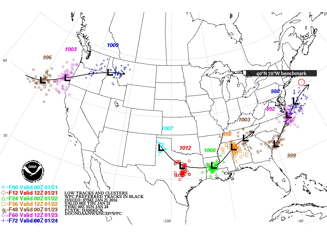
Focus on the storm track of the deeper low, the one that has the orange and brown plotted storm center positions.
The track of the imminent nor’easter and blizzard has continue to trend west of earlier model runs. This has introduced increasing uncertainty as to overall snowfall totals along the immediate coastal areas along with possible wintry mix/freezing rain. On the other hand, confidence is increasing in heavy snow for areas north and west of the city, with snowfall totals 18″+ looking likely.
Impacts – heavy snow north and west of the city, snowfall accumulations in the interior 16-20″+ looking likely. Sharp gradient in the heaviest snowfall totals approaching the coast where wintry mix, freezing rain, and even plain rain could mix in during the early afternoon Tuesday. The exact location of the extent of warm air intrusion off the ocean will ultimately determine the difference between routine totals over 1 foot and areas that receive much lower snowfall totals. The difference in some cases could be a matter of mere miles. This line could fall in and around NYC itself. Still expecting a period of blizzard or near blizzard conditions for NYC during the course of this storm even if a transition to mixed precipitation does occur. Snowfall totals could still pile up close to a foot or over prior to this transition. The possibility of freezing rain and ice introduces an additional hazard on the roads and when coupled with strong winds of 30-35mph and gusts 45mph+ could result in power outages.
Timing – light snow should begin to fall early into the overnight hours, progressively growing in intensity. In the city, overnight accumulations of 3-6″ possible, with a sharp increase in totals north and west. Heavy snow with sleet and wintry mix during the morning and early afternoon in the city, all snow in points north and west. Blowing and drifting snow with blizzard conditions possible. Snow begins to wind down during the evening hours.
Caveats – any further movement of the storm track west would result in drastically lower snowfall totals for NYC and points east along the coast. Correspondingly, an eastward shift of the storm track would put NYC itself squarely in the bullseye for the heaviest snows.
Classic major nor’easter to bring blizzard conditions to a large swath of the Northeast Tuesday just days from the official start of spring. Areas in and around NYC likely to see snowfall accumulations of over 1 foot, locally higher. This may end up being one of the biggest snowstorms/blizzards in history for the month of March in NYC.
Rest of today – the proverbial calm before the storm. Mostly sunny, cold, with high temperatures in the low-30s.
Tuesday – a major late season nor’easter will bring heavy snow and blizzard conditions to the area. Blizzard warning in effect for the entirety of Tuesday. Snow starts falling overnight into Tuesday. Heaviest snows forecast to begin around the morning rush and continue through most of the day. Blizzard conditions expected on the coast with steady north to northeast winds 30-35mph and gusts over 45mph. Visibility near zero at times. High temperatures at or below freezing. Widespread accumulations over 1 foot and approaching or exceeding 18″ expected around the NYC metro area. Details on the storm at the end of this post.
Wednesday – lingering chance for snow showers early with wrap around moisture on the backside of the departing nor’easter. Mostly cloudy with a high near freezing.
Thursday – skies clearing, high temperatures in the low-mid 30s.
Major Blizzard to Impact the NYC Region
Winter Storm Stella, as the Weather Channel refers to it, is set to bring widespread heavy snow to the area beginning overnight Monday and continuing throughout the day Tuesday.
Impacts – Snow accumulations over 1 foot, in many cases approaching 18″. Locally higher amounts, with some areas possibly approaching 2 feet. Heavy snow and blowing snow during the day Tuesday. Snowfall rates 2-4″ per hour and possibly higher in the heaviest snow bands possible. Thundersnow may accompany the strongest snow bands. Blowing and drifting snow with steady northeast winds 30-35mph and gusts 45-50mph will contribute to blizzard conditions with near zero visibility at times. East and northeast facing shorelines may experience moderate coastal flooding during high tide cycles. Heavy, wet snow at the coast combined with high winds may lead to power outages. Hazardous travel conditions, severe disruptions to aviation likely. High confidence in storm total snowfall at this point, but there is still uncertainty about whether and where mixing could occur.
Timing – Snow begins early in the overnight hours Tuesday. Light accumulations of 2-4″ possible by daybreak. Heavy snow likely beginning during the morning rush hour and continuing through most of the work day, as well as into the evening rush hour. Winds quickly intensifying from the morning and staying steady through the evening hours. Heaviest snow tapers off in the early evening hours, but snow showers could continue overnight. Winds remain strong overnight into Wednesday. Conditions improve going into the morning Wednesday.
Discussion – an area of low pressure that had its origins in the Pacific has made its way across the northern US, impacting the Northern Plains and Upper Midwest with snow. This storm system will phase with a secondary, coastal low pressure system that is currently moving up the coast from the Southeast. As these storms merge, the coastal low will undergo rapid intensification and cyclogenesis, becoming a strong Nor’easter. This storm will be drawing on subtropical moisture, and will encounter an airmass that will be quite cold due to the presence of an Arctic high pressure system prior to the storm’s passage. These ingredients will set the stage for a classic major blizzard for the Northeast late in the winter season, only days from spring.
As always, uncertainty remains about the exact location of the heaviest snow bands with this storm. Areas that are impacted by these bands can easily rack up several more inches than surrounding areas that are spared. The storm is expected to track west of the 40°N/70°W benchmark. However, during the last model runs, the storm track has trended north and west, increasing the chances for the city itself to see the heaviest snow, in addition to areas north and west. If this track shifts west some more, warmer air off the ocean wrapping into the core of the storm from the south could induce mixed precipitation with rain cutting down on totals in the city and Long Island. If the track shifts east, heavier snow would fall over points east of the city.
An eventful week of weather continues into the weekend, though not to the same degree of intensity. We will see another chance for snow, as well as rain this weekend. Temperatures rebound back to around or slightly above normal for the weekend. Looking ahead, there are some signals at another possible strong storm a couple weeks out, but it’s much to early to be certain.
Rest of today – cold, windy, sunny with areas of blowing snow. High temperatures below normal around 30ºF. Wind chills in the teens. Overnight tonight, we could pick up a light coating of fresh snow from a fast moving, and relatively weak storm system.
Below are some reported snowfall totals from yesterday’s coastal storm. As you’ll see, there was a fairly sharp cutoff between areas that received 9″ or more of snow. Long Island, Connecticut, and parts of the Hudson Valley got the largest totals. This was largely due to the fact that the most intense bands of heavy snow spent more time parked over these areas than it did in the city.
Saturday – conditions improving, along with warmer temperatures in the mid-40s under mostly cloudy skies.
Sunday – another storm system moves in from the Ohio Valley. This will bring a mixture of precipitation to the Northeast. Luckily, with high temperatures in the low-40s, we will see all rain.
Monday – winds pick up behind the departure of the storm system above, and skies should clear up as well. Temperatures should again be in the low-40s.
You’d be forgiven if you didn’t believe that a record-setting Nor’easter blizzard happened less than a week ago. A week of much above average temperatures and warm weather has quickly melted more than half of the snowpack that was left after the blizzard dropped 26.8″ (.1″ short of the all time record) in Central Park, breaking the single day storm total snowfall record with a new high of 26.6″. Except, of course, those huge snow mounds that are trapping your parked car. Warm weather, with high temperatures near or above 50ºF this weekend means that even more of this snow will melt away. Whatever’s left will likely be completely washed away mid-week next week when we’re expected to hit temperatures near 60ºF with thunderstorms possible.
Rest of today – mostly cloudy with a high near 40ºF. A passing rain/snow shower caused by a weak passing disturbance in the upper atmosphere is possible this afternoon around 1PM.
Saturday – brief clearing caused by an area of high pressure overnight will give way again to increasing clouds with high temperatures around 40ºF again.
Sunday – the high pressure moves quickly off to our east Sunday, allowing for clockwise return flow from the southwest to bring in warmer temperatures in the upper 40s under partly sunny skies.
Monday – warm temperatures continue with highs topping out around 50ºF and partly sunny skies.
Cooldown Coming
Don’t get too used to the warm temperatures because after mid-week next week, cold air returns to the Eastern United States for a period.
Blizzard Brings Drought Relief
One of the best parts about this blizzard was that it brought along some much needed precipitation precisely to areas of the region that most needed it. As you’ll see below, since the blizzard past the area of New York State experiencing moderate drought has decreased from 6.80% to 2.04%, largely because areas of moderate drought in the NYC region and Long Island have gotten slammed with huge amounts of snow that will be replenishing the local watersheds as it melts.
All eyes turn towards this weekend’s Nor’easter which will bring us the most snow we’ve seen since last winter. Confidence is growing that NYC and points south could receive over a foot of snow by Sunday. In addition, forecasters anticipate that this storm will bring sustained winds of 30mph to coastal areas with gusts as high as 40-60mph leading to whiteout blizzard conditions. However, it is important to not, even at this point, 48 hours from the start of this event, that a good deal of uncertainty remains about these forecast snow totals.
Rest of today – mostly clear with high temperatures reaching into the mid-30s but a northwest wind in the 15mph range making it feel colder.
Friday – slightly cooler with highs in the low-mid 30s, clouds I increasing through the day as the headline storm for the weekend approaches.
Saturday – snow should begin falling from southwest to northeast overnight Friday and continue throughout the day Saturday. Sustained northeast winds 25mph-30mph could lead to drifting and blowing snow, making for hazardous teavel conditions. Some potential exists that enough warmer air wraps into the storm off the Atlantic that some areas see a changeover to a rain/sleet/snow mix in the afternoon before transitioning back to all snow Saturday night. Total daytime accumulations are currently forecast between 3-7″. Overnight accumulations could be in the 4-8″ range.
Minimum snowfall for this Nor’easterMost likely snowfall totalsMaximum snowfall possible with this storm
Sunday – some lingering snow showers are possible Sunday morning but conditions should improve rapidly as cloud cover decreases with the storm exiting to our east. High temperatures are expected to be in the mid-30s.
Monday – warmer with high temperatures in the mid-30s and sunny skies.
Complicating Factors for Forecasting the Nor’easter
Model divergence – European models favor a solution that has the storm moving quicker and further south than US based models. This scenario would result in minimal snow for NYC, hence why the minimum snow forecast is only 2″.
Unpredictable snow bands – as we are all too aware from last year’s fiasco of subway shutdowns in anticipation for a blizzard that didn’t materialize, when it comes to Nor’easter type storms, where, when, and for how long deformation banding features (heavy bands of snow) set up will make or break a snowfall total forecast in either direction. However, these types of mesoscale banding features are not easy to predict with confidence before they actually start forming. Should parts of our region fall under one of these banding features where snow could be falling at rates of 1″+ per hour, you could easily see total snowfall forecasts be shattered.
Intrusion of warm air – if enough warm air works its way into this storm off the warm waters of the Atlantic (where above normal temperatures thus far this winter have kept the sea surface temperatures abnormally warm), then some areas could see a rain/sleet mix for periods of time. Forecasters are overall confident the window for this mixing is small enough that overall totals won’t be dented too much, though.
The closer this storm center tracks to the 40ºN 70ºW benchmark, the better the chances become for our are to get a lot of snow. Climatologically, Nor’easters that track closest to this benchmark have been the biggest snowmakers for the NYC region.
Weather to start this week will be rather uneventful, predominantly featuring windy, cold days, but little in the way of precipitation. We did get our first dusting of snow so far this winter in the city last night, and the potential for significantly more exists with a possible Nor’easter coming this weekend. As always, even though we’re within a week of this event, our local forecast office is only forecasting with 30% confidence due to the large changes in impact that even small fluctuations in storm track and intensity could bring.
Rest of today – we’ve already hit high temperatures for the day around 30ºF. A tight pressure gradient is causing breezy west winds near 20mph translating to wind chill values in the 10-15ºF range.
Tuesday – basically a repeat of today, but with slightly stronger winds. High temperatures will be in the upper-20s to around 30ºF with west winds in the 20-25mph leading to wind chills in the single digits to low teens under mostly sunny skies.
Wednesday – warmer, with high temperatures closer to normal in the mid-30s, calmer winds and sunny skies. There could be some flurries Wednesday night with a passing clipper system, but no accumulation is expected in the city.
Thursday – mostly sunny again with high temperatures in the mid-30s.
Possible Nor’easter This Friday – Saturday
Looking ahead towards the end of the week, there is a possibility for the first significant snowfall event in the NYC region thus far this winter. Forecasters are keeping close tabs on the possible formation of a classic Nor’easter towards the end of this week. It is important to stress that even at this point in time, there’s still considerable uncertainty about how this scenario will unfold. A deviation in the track of this coastal low too far north would result in a mainly rain event along the coast, while a deviation too far south would mean significantly less precipitation. If this scenario plays out under optimal conditions, our region would be in the northwest quadrant of this low, an area that favors the development of heavy snow. Even then, as was the case a couple winters ago, slight changes to the track and position of the heaviest snow bands could mean the difference between 5″ of snow or over a foot. Stay tuned for updates.
After an absurdly warm start to the winter, we are about to get a dose of proper weather for this time of year. While temperatures this week and the first half of January will still above normal in many cases, they will be considerably cooler than December and be closer to normal than not. This week, we start with a messy and complex storm (the same that spawned deadly tornadoes in Texas and has brought blizzard conditions to New Mexico, and an ice storm to Oklahoma) that affects the area tonight into Tuesday with a mix of rain, sleet, freezing rain, and snow, depending on how far north you are. Yet another round rain and snow further north from the city is possible Wednesday.
Rest of today – seasonably cool with high temperatures only in the low-mid 40s. Increasing clouds ahead of a warm front that will be the focus for the precipitation later tonight. Things get interesting overnight as precipitation begins to spread over the area from southwest to northeast. Near the coast, surface temperatures are expected to remain warm enough (upper-30s) to largely preclude the possibility of significant wintry precipitation, however, sleet could mix in with rain to at the start of this storm before things shift over to all rain. Further west and north will be another story, with areas expecting anything between .25″ of ice to 2-4″ of snow/sleet accumulation before rain starts falling.
Tuesday – as temperatures warm with daybreak, wintry precipitation should transition entirely to rain. Rain is expected to last throughout most of the morning into the early afternoon hours. East winds ahead of the warm front mentioned above will be in the 15-20mph range before shifting to the north. High temperatures in the city are expected to hit the upper-40s to around 50ºF.
Wednesday – we’ll get another shot at rain as the cold front railing the warm front pictured above pushes through late on Wednesday into the overnight hours. Despite increasing clouds, forecasts still call for high temperatures in the low-50s.
Thursday – a lingering chance of rain remains on the backside of the cold front. High temperatures are expected to be about the same as Wednesday near 50.
As many of you woke up this morning, you were probably wondering, what happened here? This storm seemed like a dud. True, the snowfall totals in and around NYC were lower than initially forecast, but portions of the area did get slammed with over 20″ of snow. To put it simply – as I had laid out in the caveats from the last post, slight changes in track of this storm dramatically altered the placement of mesoscale banding features, hence leading to a sharp cutoff in snowfall totals from east to west.
Snowfall Totals
Looking at this snowfall totals map, you can easily make out the line that demarcates where the heaviest snow bands stopped their westward march. We got what appears to be around 6-8″ in the city, but just east of us in Nassau the totals jump to 12″ and then just east of that in Suffolk we see 20″+ totals.
Snowfall total map
On a larger scale, you can see the areas that got the highest snowfall totals, corresponding to where the heaviest bands of snow were able to pass over.
Forecasters are saying that the storm tracked further east than they expected by about 50-75 miles, which literally would have meant the difference from us having 6-8″ snowfall totals here in the city to easily 12-18″+. Now before we all go blaming them for a dud forecast (that some are already saying wasted taxpayer money), there are a couple things to consider:
Forecasters utilize a suite of different computer models to come up with these forecasts, in this case they favored the NAM (North American Mesoscale) and ECMWF (European Center for Medium Range Weather Forecasts) over the GFS (Global Forecast System), UKMET (United Kingdom Meteorology), and Canadian models. There were specific reasons for doing so, one of which is based on forecasters’ experience with these types of systems and which models have historically done a better job with them. ECMWF often does a very good job of modeling strong cyclonic systems like this (and is often favored in forecasting tropical cyclones). In this case, the NAM and ECMWF had the storm moving just far west enough to put us on the cusp of those high snowfall totals.
Mesoscale (medium scale) banding features are notoriously difficult to forecast in these types of storms. The exact position, orientation, and movement of these banding features is often not known until the storm is already ongoing. This is due to a number of complex atmospheric interactions that are responsible for these features forming. To take another example, the Storm Prediction Center can forecast that severe thunderstorms are likely over a certain area 2-3 days out. However, it is exceedingly difficult even the day of to know which towns will get hit by individual storm cells/tornadoes, etc. Despite advances in supercomputing power, forecast skill and accuracy, and understanding of meteorology, these mesoscale events remain challenging to get right even for the most experienced forecaster. So while the general public can say, “I told you so”, I’d challenge any one of them to forecast the next Nor’easter, and the one after that, and so on, and get them right with more skill than a straight up guess.
Anyway, since we all got the day off (the political response to this storm is a whole other debate beyond the scope of this blog), forget about the forecast being a dud and go out to take advantage of a day off!
A major nor’easter will be bringing a high impact blizzard throughout the NYC region tonight through Tuesday midday. Beginning this evening, snowfall will increase in coverage from south to north. Periods of heavy snow are expected with snowfall rates of 2-4″ per hour, with thundersnow occurring in the heaviest bands of snow. Extended periods of high winds, with sustained winds at least 35mph and gusts over 40mph (even up to 60mph) will lead to blowing and drifting snow, blizzard conditions, and near-zero visibility. Widespread snowfall totals of between 18″-24″ possible throughout the area, with locally higher amounts.
Snowfall Totals
Since yesterday afternoon, forecast models have backed off a bit on the overall total accumulations. At this point yesterday, the quantitative precipitation forecast (liquid water equivalent total) was as high as 2.7-2.8″ and broadly over 2.5″ across much of the area. As seen below, those liquid water equivalent numbers have gone down by about half an inch.
Liquid water equivalent forecast totals
This decrease in overall precipitable water has led to a corresponding downgrading of the overall snowfall totals. Using a 12:1 snow to water ratio, a drop in precipitable water by half an inch translates to a decrease in snow totals by 6″. Indeed, the National Weather Service has decreased the likely totals from 27″+ for many places to closer to 20-22″.
Snowfall accumulation total forecastHighest probabilities for snowfall totals in excess of 18″ during the 48 hour period ending 7AM Wednesday now rests over Southern New England, with the bullseye setting up right over Boston and immediate suburbs. Here in NYC, we are in the range of 30%-50% probability of receiving over 18″ – notice how abruptly the probability goes up as you go further north and east.
Timing
Light snow has already begun falling over the area, however the heaviest snow will not be occurring until after 8PM tonight. The most intense period of this storm is expected overnight tonight, as a deformation banding feature forms and begins moving slowly inland. Based on the simulated radar loop below from the NAM (North American Model), the peak intensity of snowfall looks like it will occur between 1AM-7AM overnight into Tuesday. Snow appears to taper off over NYC by 1PM tomorrow.
It does appear that a secondary set of banding snow will linger over eastern areas of the metro region throughout the afternoon Tuesday until as late as 4PM tomorrow.
By the way, part of the reason the main area of highest snowfall totals is now shifting to Southern New England and Boston is because it is anticipated that these areas will see moderate to heavy snow for much longer than we will here.
NAM model simulated radar output for this storm
Impacts
Snow, heavy at times, beginning in earnest this evening especially after 8PM. Some thundersnow possible, with the most intense snow occurring overnight. Strong sustained winds up to 35mph with gusts over 40mph and as high as 60mph will lead to blizzard conditions with blowing and drifting snow cutting visibilities down to near zero.
Caveats
Forecasters have been pointing out that there continues to be some slight disagreements between different models even though this storm is imminent. Snowfall total forecasts for storms like this one are notoriously difficult to predict with a high degree of accuracy prior to the event itself. This is due to the fact that the exact placement, movement, and intensity of the deformation banding feature on the northwest flank of the low pressure center is hard to foresee until the storm is ongoing. With snowfall rates as high as 2-4″ per hour within this banding feature, a difference of a couple hours under it could translate to 4-8″ difference in overall accumulation in any one location. Same thing with location, as one location that misses the most intense portion of the banding feature could easily miss out on 6″+ in total accumulation. Furthermore, a slight change in the thermal profiles within this type of storm could alter the snow to water ratio to be higher, and of course, a change from 12:1 to 15:1 would result in a dramatic difference in totals.


