Category Archives: Freezing Rain

NYC Detailed Forecast for Jan 20, 2019

A major winter storm is set to bring immediate impacts to the entire Tri-State region with a mixed bag of wintry precipitation ranging from snow to sleet, freezing rain, and rain. Coastal flooding and even urban street flooding could be a concern. Temperatures will plummet in the wake of this storm, with Arctic winds blowing from the northwest bringing the coldest air of the season and the potential for a flash freeze. The track of this storm has bounced around a bit throughout the week, though at the time of this writing, a warmer scenario with a storm track further north closer to the coast looks more likely.

My Forecast
High: 48°F | Low: 17°F | Max sustained winds: 35 mph | Total QPF: 1.40″ | Total snow accumulation: 1.00″ – verification for temperatures and precipitation will come from METAR data for the period between 1AM Sunday and 1AM Monday (06Z Sunday to 06Z Monday) at LGA. Wind speed verification will draw on the daily climate summary from the National Weather Service.

Verification
High: 40°F | Low: 15°F | Max sustained wind: 38 mph | Total precipitation: 0.80″ | Total snow: 0.00″ – Decent job of handling max sustained wind and the low, however, I missed the mark on high temperatures and overall precipitation by a large margin. I’ll post a more in-depth post-mortem analysis on this later this weekend. However, I do want to provide an initial assessment of the reasons behind my forecast bust on high temperatures and precipitation. These both have to do with the progression of the coastal and warm fronts associated with this storm. The warm front never made it further north than offshore of Long Island. As a result, we didn’t really get into the warm sector as I thought we would. This resulted in more northeasterly flow, keeping temperatures suppressed. The timing of the heaviest precipitation happened to be in the immediate six hour period preceding the start of my forecast window, when another 0.64″ of precipitation fell. I’ll look a bit more into this in the post-mortem, but I suspect the storm progressed a bit faster than forecast model data suggested on Saturday afternoon.
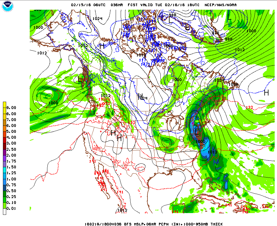
Weather Prediction Center surface forecast valid 7AM Sunday.

Synoptic Set Up
A large scale storm system with origins from the Pacific has been marching through the Ohio Valley and will eventually move offshore right in our vicinity. As this surface low continues to intensify, a warm front will first push into the coastal areas of the region. Ahead of this, snow should develop late Saturday, heavy at times. Eventually, as the warm front moves north of us, we’ll experience a transition over to rain. As the surface low progresses east, precipitation will end in the afternoon Sunday. This low will then continue to deepen, causing strengthening winds from the northwest to usher in an Arctic airmass and the coldest temperatures of the year.

Weather Prediction Center’s most recent storm track map. There’s still some uncertainty at this point with the track. However, trends have been pushing the storm track north since yesterday and even within the cluster of orange dots near us denoting the storm’s forecast position at 7AM Sunday, not too many are far south enough to see a colder scenario pan out.

High Temperatures
National Weather Service only recently released a warmer forecast in the mid-40s, before which they were showing highs in the mid-30s. However, most other sources are suggesting a substantially warmer high temperature in the upper-40s to near 50°F. In this case, I tend to agree with the consensus shaping up on the warmer side, with MOS guidance being on this warm side, and the generally reliable National Blend of Models similarly warm. The current most likely storm track places the area in the warm sector of this low, with MOS guidance showing an extended period of east-southeasterly winds veering to the south and southwest and blowing at a good clip, I can buy into the idea there will be decent warm advection and a surge of warm air to push temperatures up in to the upper-40s. Furthermore, I don’t see a lot of potential for evaporational cooling occurring, since the atmosphere will start off saturated during the morning hours (it’ll be raining).

Low Temperatures
With strong northwest winds expected to develop on the cold flank of the surface low as it exits the area, low temperatures are likely to actually occur late overnight going into Monday. This is because warm advection will proceed the bulk of the rain Sunday morning. I’m siding with a blend of low temperatures from NAM, GFS MOS, and National Blend of Models.

NAM forecast sounding for 7PM Sunday, note the environmental temperature line (red/yellow) from the surface upwards to about 875 mb is well-mixed, parallel to the nearest line of dry adiabatic ascent (grey lines slanted to the left at ~45 ° . This is a set up that favors strong winds.

Max Sustained Winds
S
trong northwest winds are expected to develop behind the exiting low. A well-mixed layer is visible in forecast soundings, and this suggests the potential for the strong winds aloft at 850 mb to mix down. Sustained wind speeds could easily be in the 25-30 mph range with higher gusts. The intensifying low should also lead to an isallobaric component (winds becoming stronger in response to a deepening low) to the wind, which I think could push wind speeds to 35 mph. I believe the strongest winds of the day are actually coming after the precipitation since there’s going to be a warm nose above the surface, putting an inversion in place that would diminish downward momentum transfer while rain is coming down.

NAM forecast model showing 850 mb frontogenesis early Sunday morning at 4AM. These values of frontogenesis entail potential for bands of heavy rain and snow, with plenty of lift possible to propel precipitation.

Total Precipitation
Several of the key ingredients needed for a heavy precipitation look to be coming together for this storm. This includes several strong vorticity maxima at 500 mb moving through. At the 300 mb level, a jet streak is forecast to be in the vicinity, but I don’t see this area sitting under a favorable jet streak quadrant that would support additional lift. Most of the lift here I think will come from the combination of 500 mb vorticity maxima and 850 mb isentropic lift depicted above. I actually see some low potential for elevated convection that could spur bouts of this heavy precipitation to fall. Moisture looks robust, with an 850 mb low-level jet forecast to develop as well. This should support deep moisture and lends further credence to the potential for heavy rain. Given the temperature profiles, it appears the risk of freezing rain and sleet is low at the coast, though more significant north of the city.

NYC MLK Jr. Weekend Weather – Jan 18, 2019

The dusting of snow we got last night into today is just a small preview of what lies ahead this weekend. A major storm, that first brought heavy rain to the west coast, has been tracking across the nation and will impact the region late Saturday through Sunday with potentially a mixed bag of everything from snow, sleet, freezing rain, rain, urban street flooding, coastal flooding, and strong winds that could result in power outages and tree damage (esp. if ice accumulates). Behind this storm, the coldest air of the new year surges in, bringing a bitterly cold start to next week. I’ll post an in-depth forecast of the incoming winter storm tomorrow.

Rest of today – the veritable calm before the storm. High pressure briefly establishes itself behind the weaker disturbance that brought us light snow overnight. Skies slowly becoming partly cloudy. High temperatures in the low-40s. Overnight lows colder around 30°F.

Saturday – should start off as a decent day with partly cloudy skies. Cloud cover increases through the day, and snow starts to spread from southwest to northeast during the late afternoon hours. High temperatures in the mid-30s. Overnight lows right around freezing will critically impact how much snow accumulation we get before what is widely expected to be a transition over to wintry mix of sleet and freezing rain, then finally bouts of heavy rain leading into Sunday. If a warmer scenario plays out, we’ll get less snow and ice, and more rain. Various forecast sources call for between 1-4″ of snow and sleet accumulations, with up to as much as 0.10″ of ice.

Weather Prediction Center surface forecast for 7AM Sunday. A real mixed bag of various precipitation types all along the Mid-Atlantic and Northeast

Sunday – high temperatures will continue to play a pivotal role Sunday in determining precipitation type. Some forecast sources suggest colder high temperatures in the mid-30s, while others remain warmer, in the upper-30s to even 40°F. There is broad agreement that the day starts off with plain rain but then transitions back to wintry mix of sleet, freezing rain, and finally snow. The differences in high temperature will be pivotal to the timing of this transition, with a warmer scenario keeping things all rain longer. As the center of the low responsible for the storm moves off to the north and east, it will continue intensifying and the pressure gradient around it will increase quite dramatically. Robust northwest winds are expected to develop, rapidly advecting cold, Arctic air into the area. The intensity of this cold advection will govern how quickly temperatures start to plummet during the second half of Sunday. It would appear that temperatures will be well below freezing by the late afternoon hours. This prompts concerns for a flash freeze of any standing water or untreated surfaces, leading to dangerous travel conditions. Temperatures will continue dropping overnight Sunday, with overnight lows going into Monday only around 10°F. Overall, this forecast shapes up to be a slushy mess, with a layer of snow coated by ice and sleet, melted by rain, but then re-frozen with an additional light layer of sleet and ice before all is said and done.

Weather Prediction Center’s plot of ensemble forecast low tracks/positions. Note that there’s still decent uncertainty even at this stage approaching the storm. The pink cluster denotes storm center positions by 7AM Sunday. Though they seem closely clustered, even a shift of the storm track 25-50 miles north or south could result in big differences in terms of whether locations at the coast receive more snow and frozen precipitation (southerly track) versus more of a rain event (northerly track).

Monday (MLK Day) – if you have the day off, count yourself lucky, because this is shaping up to be a brutally cold day where temperatures topping out in the upper-teens despite ample sun. Continued windy conditions will produce wind chill values below zero. The bitter cold continues into Tuesday morning with overnight lows again in the low-teens.

NYC Blizzard Update #2 – Mar 13, 2017

The track of the imminent nor’easter and blizzard has continue to trend west of earlier model runs. This has introduced increasing uncertainty as to overall snowfall totals along the immediate coastal areas along with possible wintry mix/freezing rain. On the other hand, confidence is increasing in heavy snow for areas north and west of the city, with snowfall totals 18″+ looking likely.

Impacts – heavy snow north and west of the city, snowfall accumulations in the interior 16-20″+ looking likely. Sharp gradient in the heaviest snowfall totals approaching the coast where wintry mix, freezing rain, and even plain rain could mix in during the early afternoon Tuesday. The exact location of the extent of warm air intrusion off the ocean will ultimately determine the difference between routine totals over 1 foot and areas that receive much lower snowfall totals. The difference in some cases could be a matter of mere miles. This line could fall in and around NYC itself. Still expecting a period of blizzard or near blizzard conditions for NYC during the course of this storm even if a transition to mixed precipitation does occur. Snowfall totals could still pile up close to a foot or over prior to this transition. The possibility of freezing rain and ice introduces an additional hazard on the roads and when coupled with strong winds of 30-35mph and gusts 45mph+ could result in power outages.

Timing – light snow should begin to fall early into the overnight hours, progressively growing in intensity. In the city, overnight accumulations of 3-6″ possible, with a sharp increase in totals north and west. Heavy snow with sleet and wintry mix during the morning and early afternoon in the city, all snow in points north and west. Blowing and drifting snow with blizzard conditions possible. Snow begins to wind down during the evening hours.

Caveats – any further movement of the storm track west would result in drastically lower snowfall totals for NYC and points east along the coast. Correspondingly, an eastward shift of the storm track would put NYC itself squarely in the bullseye for the heaviest snows.

NYC Weekend Weather – Dec 15, 2016

Apologies for the lack of updates recently. Winter weather has come in full force a few days ahead of the actual Winter Solstice. We’ll see possibly record-tying or record-breaking cold Friday in some parts of the area, our first measurable snowfall in the city this season, all while temperatures swing about 30ºF from now through Sunday. The medium term shows a continuance of average to below-average temperatures in the upper-30s and low-40s.

Rest of today – we had some passing snow showers this morning, and there will be another chance for snow showers this afternoon. The main story will be the wind, cold temperatures, and low wind chills. A wind advisory is in effect for today with a high wind warning in place for tonight. Sustained winds of 20-30mph are expected, with wind gusts between 40mph to as high as 60mph possible later. Combined with high temperatures only in the mid-20s, this will result in wind chills of between 0-10ºF in the city.

screen-shot-2016-12-15-at-10-06-40-am

Friday – slightly colder than today with highs in the mid-20s, with a very cold start to the morning as overnight lows drop into the teens. Winds will slowly abate through the course of the day as the high pressure center depicted above moves east over us, lessening the pressure gradient. Overnight Friday, a warm front approaches and brings the possibility for 1-2″ of snow.

Saturday – the snow will continue into the first half of Saturday with the possibility of 1-2″ additional inches of accumulation before temperatures warm and winds turn towards the southwest. There is some question as to whether some period of freezing rain will occur before a transition to all rain from south to north in the afternoon hours. High temperatures rebound nicely into the upper-40s in the wake of the warm front passing through.

99fndfd_init_2016121500

Sunday – a cold front will follow the passage of the warm front mentioned above, but that shouldn’t happen until late Sunday. Ahead of that cold front passing, temperatures will continue to warm into the low-mid 50s as rain continues to fall. That snow won’t stick around long!

NYC Weather Update – Feb 15, 2016

After a brief deep freeze, we’ll see a significant change in the weather with a complex storm system that will affect the area to start the week, bringing a mix of precipitation along with much warmer temperatures. Things quiet down by mid-week, and temperatures moderate towards more normal levels.

Rest of today – cloudy with temperatures rising into the low-mid 30s. Flurries have already begun falling in some parts of the city. Snow will become more steady and increase in coverage during the course of the afternoon. For those of you who do not have the day off, it’s shaping up to be a messy commute with snow transitioning to a wintry mix, with periods of freezing rain during the evening commute. Prior to the transition from snow, areas along the coast could pick up 1-2″ of snow, with higher totals in the interior north and west.

Screen Shot 2016-02-15 at 9.10.38 AM

Tuesday – after a brief dip in temperatures early on during the overnight hours, temperatures will actually start increasing as a warm front passes through. Since the ground itself is still quite cold due to the deep freeze this past weekend, freezing rain and wintry mix will still be lingering around until temperatures start to climb well into the mid-upper 30s. At that point, we’ll transition over to all rain, and periods of moderate to heavy rain will likely affect the area Tuesday afternoon into the evening hours as a cold front pushes through. Temperatures will be very warm Tuesday, with highs topping out in the mid-50s – 15-20ºF above normal for this time of year.

96fndfd_init_2016021500

Wednesday – high pressure starts to build back in after the storm system moves out Tuesday. Temperatures cool off back into the mid-40s, with clearing skies.

Thursday – cooler, with high temperature around 40ºF and sunny skies.


NYC Weather Update – Dec 28, 2015

After an absurdly warm start to the winter, we are about to get a dose of proper weather for this time of year. While temperatures this week and the first half of January will still above normal in many cases, they will be considerably cooler than December and be closer to normal than not. This week, we start with a messy and complex storm (the same that spawned deadly tornadoes in Texas and has brought blizzard conditions to New Mexico, and an ice storm to Oklahoma) that affects the area tonight into Tuesday with a mix of rain, sleet, freezing rain, and snow, depending on how far north you are. Yet another round rain and snow further north from the city is possible Wednesday.

Rest of today – seasonably cool with high temperatures only in the low-mid 40s. Increasing clouds ahead of a warm front that will be the focus for the precipitation later tonight. Things get interesting overnight as precipitation begins to spread over the area from southwest to northeast. Near the coast, surface temperatures are expected to remain warm enough (upper-30s) to largely preclude the possibility of significant wintry precipitation, however, sleet could mix in with rain to at the start of this storm before things shift over to all rain. Further west and north will be another story, with areas expecting anything between .25″ of ice to 2-4″ of snow/sleet accumulation before rain starts falling.

93fndfd_init_2015122812


Tuesday – as temperatures warm with daybreak, wintry precipitation should transition entirely to rain. Rain is expected to last throughout most of the morning into the early afternoon hours. East winds ahead of the warm front mentioned above will be in the 15-20mph range before shifting to the north. High temperatures in the city are expected to hit the upper-40s to around 50ºF.

Wednesday – we’ll get another shot at rain as the cold front railing the warm front pictured above pushes through late on Wednesday into the overnight hours. Despite increasing clouds, forecasts still call for high temperatures in the low-50s.

Thursday – a lingering chance of rain remains on the backside of the cold front. High temperatures are expected to be about the same as Wednesday near 50.

NYC Weather Update – Nov 30, 2015

We start this week off with cool, but slightly above average temperatures in the upper-40s to around 50ºF. A warm up occurs midweek along with a passing frontal system, then a return back to seasonably cool temperatures takes place to end the week.

Rest of today – increasingly cloudy with high temperatures peaking in the mid-upper 40s.

Tuesday – a warm front approaching from the south will provide for an increasing chance of rain tonight into early Tuesday. Temperatures in some inland areas may support a brief period of freezing rain before transition to all rain occurs early in the morning. Temperatures should reach around 50ºF with periods of light rain.

Wednesday – temperatures will warm into the mid-upper 50s by Wednesday following the passage of the aforementioned warm front and prior to the passage of a cold front. Rain continues in periods throughout the day and begins to taper off late Wednesday going into the overnight hours.


noaad3


Thursday – once the cold front dives through, winds pick up from the northwest again, and drive temperatures down into the upper-40s to near 50ºF Thursday. Expecting dry and mostly sunny conditions otherwise.

NYC Weekend Weather – Mar 13, 2015

The weekend gets off to a wet start, with rain beginning overnight and Saturday a complete washout. By Sunday, conditions will improve and there will be a slight warmup to start the week, before we return to below normal temperatures by mid-week next week.

Rest of Today – increasing clouds will be a precursor for rain later in the overnight hours. If you plan on being out past midnight (really more like 2AM), grab an umbrella just in case. The bulk of the rain doesn’t look to begin until after 2AM, however, once it starts, it will be essentially continuous until Saturday evening. Prior to the passage of a warm front late overnight into Saturday morning, overnight lows may be cold enough to support some mixing of sleet for a brief period in the city. There is actually a freezing rain advisory for northern areas, where a colder thermal profile could support some freezing rain.

Simulated radar image for 3AM EST, Saturday, Mar 14, 2015. High Resolution Rapid Refresh model.

Saturday – it will actually be a mild day on Saturday subsequent to the passage of the warm front mentioned above. Any freezing rain/sleet that occurs early in the morning will quickly transition to rain, increasing in intensity during the morning. High temperatures near 50, combined with drenching rain, should be enough to finally washout any remaining snowpack near the city (although places like Long Island that got more snow this season will probably see it persist).

Sunday – there could be a couple remaining sprinkles Sunday morning, but overall, this should be a dry day, partly sunny, and breezy day. High temperatures will be near normal around the mid-40s.

Monday – it’ll be a nice day Monday with a warm front passing through, and high temperatures in the normal range near 50.

Tuesday – another day of normal temperatures near 50. A cold front pass through by Wednesday, which will lead to a cooler than normal day.

NYC Weather Update – Mar 2, 2015

March will start off with quite an active, messy week for us. During the middle of the week, we’ll see snow, rain, and then more snow, before we end off the week with temperatures well below normal once again.

Tuesday – clouds will begin to increase throughout the day with chances for snowfall increasingly steadily as well. Not much in the way of accumulating snow is expected during the day Tuesday. High temperatures around 30.

Wednesday – overnight Tuesday into Wednesday, temperatures will actually rise as a warm front pushes through. This will allow temperatures on Wednesday to top 40. Snow early on will give way to sleet, then eventually transition to all rain. This period of rain should melt some of the existing snowpack, and there could be some minor/nuisance flooding of poor drainage areas as this occurs.

noaad3

Thursday – once the cold front depicted above pushes through late Wednesday, cold air will rapidly fill in behind it and allow for temperatures to drop back into the mid-20s. As this occurs, a second wave of low pressure is expected to form over the Mid-Atlantic and move over the area. This may lead to enough precipitation to warrant a Winter Storm Warning, with 6″ of snow possible by Thursday afternoon. Highs will be near 30. gfs_namer_066_1000_850_thick


Friday – as these storms finally move away, Friday will be a sunny day, but with Arctic air back in place over the area, we’ll be once again welcoming high temperatures in the mid-20s, which at this point is over 15 degrees below normal.


NYC Weather Update – Feb 16, 2015

Sunday night’s lows were the coldest of the year thus far, indicative of the coldest airmass to hit the area in recent memory. Again, according to climatology, the last time New York City itself hit a low of zero was in January 1994. Unfortunately, the cold snap does not show any signs of abating during the week, although the first half of the week will see daytime high temperatures in the mid-upper 20s as opposed to the teens. We’ll finish the week off back into the teens before a warmup to above freezing with an approaching storm system this weekend. Behind that – you guessed it, another round of arctic air and abnormally cold temperatures.

Rest of today – cold and overcast, with high temperatures not even getting to 20 in the city. Snow should begin falling overnight, with generally light accumulations by daybreak.

Tuesday – slightly warmer with high temperatures in the mid 20s, but also with a chance for snow as a storm system now dumping snow across a vast swath of the South passes well to the south of us. We could still end up picking up 2-5″ of snow in the city, with higher amounts along the south facing shores of Long Island and minimal accumulation north of I-84.

Snowfall total forecast for Tuesday

Wednesday – a weak cold front will pass through Wednesday, and may give us a small chance for light snow, otherwise, expecting cloudy skies with high temperatures in the mid-upper 20s.

Thursday – behind that cold front, we get our next shot of Arctic air, with overnight lows into Thursday struggling to hit 10 in the city, and zero and below in outlying inland areas. Daytime highs will only be in the mid-teens despite ample sun. Thursday night, we might get another shot at low temperatures hitting zero in the city, with lows below zero across most inland locations.

gfs_namer_063_1000_850_thick

Friday – basically a repeat of Thursday, sunny but with brutally cold temperatures in the mid-teens.

Over the weekend – watching for the development of a storm system that could bring some wintry mix/freezing rain to the area, but finally give us a break from below freezing temperatures.

More Cold on Tap to End February

After the weekend storm, we get yet another reinforcing blast of Arctic air to end the month of February. Below, you’ll see the Climate Prediction Center‘s 8-14 day outlook spanning February 23 – March 1. We’re in a region with a greater than 60% probability of experiencing below average temperatures for this period.

Climate Prediction Center 8-14 day outlook for Feb 23 - Mar 1
Climate Prediction Center 8-14 day outlook for Feb 23 – Mar 1