Tag Archives: new york city july 4th weather

NYC Detailed Forecast for July 4, 2019

It looks like we’re going to get lucky for Independence Day this year in NYC. While many areas of the Eastern US may see a chance for rain, the Northeast should remain under the influence of strong enough high pressure that we stay dry. That means good news for all the outdoor activities folks have planned coming up! This will be my first detailed forecast that draws on the recently released GFS FV3 forecast model upgrade, so it will be interesting to see how this upgrade performs.

My Forecast
High: 88°F | Low: 74°F | Max sustained winds: 15 mph | Total precipitation: 0.00″ – verification will come from METAR data for the period between 2AM Thursday and 2AM Friday (06Z Thursday to 06Z Friday) at LGA (LaGuardia Airport), and the KLGA Daily Climate Report

Verification
High: 93°F | Low: 71°F | Max sustained winds: 16 mph | Total precipitation: 0.00″ – Spot on with the wind forecast for yesterday. It was a good call to bump that forecast up with possible sea breeze enhancement in the mix. Unfortunately, these winds didn’t do enough to cool temperatures off during the day, and I was off by 5°F for the high temperature. Skies turned out to be pretty much sunny the whole day and while statistical forecast models should factor in urban heat island effects, it would have been prudent to still have forecast at least 90°F in light of this. Also, given the 850 mb relative humidity profile, I should have probably sided with a less cloudy outlook that would have favored warmer high temperatures. Of note, the new GFS model had issues initially with a cold bias that should have been corrected. In this case, it was warm on the low, but too cool on the high. This is worth noting even though these two points of data aren’t necessarily indicative of a trend.

Weather Prediction Center surface forecast for 8PM Thursday

Synoptic Set Up
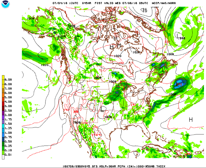
A stationary front currently along the northern tier of Illinois, Indiana, Ohio, Pennsylvania and western New York will attempt to push northwards tomorrow as a warm front. However, with a 500 mb ridge aloft and an area of surface high pressure over the Northeast and translating over the Gulf of Maine, this frontal boundary is forecast to become stationary, holding just southwest of the NYC metro area. Moisture above the surface looks modest, and without any impulses of low pressure at the surface or troughs aloft, there doesn’t appear to be any support for precipitation.

NAM 500 mb heights and vorticity valid for 8PM Thursday. Note the presence of a ridge over the Northeast (upside-down U pattern of the black height lines)

High Temperatures
GFS, NAM, and NBM agree that July 4th a warm day. All three statistical models come in at between 88-89ºF for high temperatures. EKDMOS (ensemble MOS) 50th percentile matches is very close, at 87-88ºF. The only hitch to warm temperatures is that NAM shows the possibility for low clouds and wind directions are forecast to veer from east-northeast to southeast. Cloud cover could eat into temperatures rising too much, and winds coming from the directions indicated would bring a cooling influence of marine air with sea surface temperatures still in the low-60s at this point in the season. With these factors in mind, but also keeping in mind the effects of the urban heat island, I’ll side with a middle of the road forecast of 88ºF.

Low Temperatures
NAM and GFS MOS both show the chance that the low temperature during this forecast period may actually fall overnight going into Friday. Either way, both are very close showing lows ranging 73-75ºF. EKDMOS 50th percentile shows 74-75ºF for the low. Increasing cloud cover should stall any serious radiational cooling, and there’s little indication of any temperature advection either way with weak winds. I’m again going with the mean here and siding with a forecast of 74ºF for the low.

Max Sustained Winds
NAM, GFS, and NBM average out to 8 knots for the max sustained wind tomorrow. EKDMOS is more aggressive with winds in the 50th percentile about 13-15 knots. While forecast soundings don’t show too much evidence to support a forecast above 10 knots since the entire wind profile looks remarkably calm for tomorrow, this same tendency to weak synoptic winds could allow for a fairly robust sea breeze to develop, and this could be the what allows sustained winds to top 10 knots. I’ll go with the low-end of the EKDMOS and call for 13 knots (15 mph).

GFS forecast sounding for 8PM Thursday. Indications of high clouds are shown, but low levels remain dry. Wind profile in this forecast looks weak with no winds above 20 knots forecast anywhere in the atmospheric column.

Total Precipitation
High pressure is forecast to be in control, with a 500 mb ridge in place. There aren’t any frontal boundaries moving through to create lift and even if there were, there simply isn’t enough moisture to support precipitation. Both the forecast sounding above and 850 mb forecast for relative humidity and winds below show moisture values that are insufficient to bring about any precipitation.

NAM forecast for 850 mb winds and relative humidity at 8PM Thursday

NYC Weather Update – Jul 1, 2019

Weather this week will mostly be governed by the presence of high pressure, with the exception of a cold front sweeping through Tuesday night into Wednesday that could bring some showers and thunderstorms. Temperatures will remain warm in the upper-80s and low-90s during this time. July 4th festivities look to be safe from any rain at this time.

Rest of today – sunny skies with high temperatures in the mid-80s. Overnight lows in the low-70s.

Weather Prediction Center surface forecast for 8PM Tuesday

Tuesday – mostly sunny with high temperatures in the upper-80s, close to 90°F. Chance of showers and thunderstorms later in the day as a cold front approaches from the north. Overnight lows in the low-70s.

Wednesday – high pressure starts building again with mostly sunny skies expected. High temperatures in the upper-80s with overnight lows in the low-70s.

Climate Prediction Center forecast for temperature trends between Jul 6-10, showing possibility for above average warmth to continue into the weekend.

Thursday (Independence Day) – another day of slightly above average warmth with high temperatures forecast in the upper-80s. Increasing clouds due to the approach of a weakening warm front from the southwest. Overnight lows in the low-70s, rain should hold off for fireworks viewing.

NYC Independence Day Weekend Weather – Jun 30, 2017

A hot and active weather pattern sets in for this holiday weekend. Despite multiple rounds of possible showers and thunderstorms, this will be far from a washout. Most of the precipitation looks to be late in the day or overnight, leaving most of the day clear for all manner of outdoor activities. The weather clears up in time for the holiday itself.

Rest of today – warm, humid, high temperatures in the upper-80s with a mix of sun and clouds. There’s a chance for showers and thunderstorms late in the day and into the overnight hours, more likely west of the city. It remains to be seen if organized showers remain intact as they approach much more stable air at the coast.

Saturday – another warm and humid day with a chance for isolated showers and thunderstorms. High temperatures in the mid-upper 80s.

Sunday – best chances for rain are overnight into Sunday. Another hot day in store as a slow moving cold front to the west keeps the door open for hot and humid tropical air to flow into the area from the southwest.

Monday – with the cold front behind us, fair weather with high temperatures in the mid-80s and lots of sun.

NYC Weather Update – Jul 4, 2016

Rain moves through tonight, and then temperatures warm through the course of the week as a Bermuda high takes control. There’s a chance for showers and thunderstorms Thursday – otherwise this week will certainly feel like summer.

Rest of today (Independence Day) – increasingly cloudy, with a high near 85ºF. Forecasts last week seemed to indicate a rain-free weekend outside of Friday night when we experienced some severe thunderstorms. It now appears that an area of low pressure tracking to our south will bring rain to the area tonight. Currently, the timing of the rain appears to bring it in the city right around the time that the fireworks display is scheduled to kick off. The heaviest rain won’t begin falling until later tonight, so I don’t think this will wash the fireworks out, but it will result in less than ideal viewing conditions if you plan on being outside at the display.

Screen Shot 2016-07-04 at 1.56.57 PM

Tuesday – steady rains should end by the morning rush tomorrow, though a lingering shower could pop up till around noon. Decreasing clouds with high temperatures in the mid-80s.

Wednesday – temperatures heat up into the low-90s, with dewpoints holding steady in the mid-upper 60s, it will feel like August. A Bermuda high will take hold through the end of the week, which could bring our first heat wave of the season.

Screen Shot 2016-07-04 at 1.50.08 PM

Thursday – mostly sunny with a chance of thunderstorms developing late in the day. High temperatures around 90ºF.