Tag Archives: storms

NYC Midweek Weather Update – Mar 19, 2014

Rain is on the way this Wednesday afternoon. Temperatures should be in the mid 40s around the city. We’re not expecting anything too heavy in terms of precipitation, more likely a light, showery type of event.

Here’s an infrared satellite image of the incoming low pressure system that will be our rainmaker today and tonight. Note the classic comma head formation starting to take shape, indicating a low pressure center with a trailing cold front.
Untitled2

Thursday, the first day of spring, will be a dry day, even though the cold front will push through, easterly winds associated with the departing low pressure center will keep overnight temps up. Highs on Thursday should be around 50 with mostly sunny skies.

Friday promises to be another dry day with sunny skies and a high right around average for this time of year at 50.

Saturday another weak low pressure system will move through and bring a chance for rain. The cold front coming along with this low pressure center will have a bigger bite: a polar high pressure will slide down behind this front, leading again to much colder temps Sunday-Tuesday.

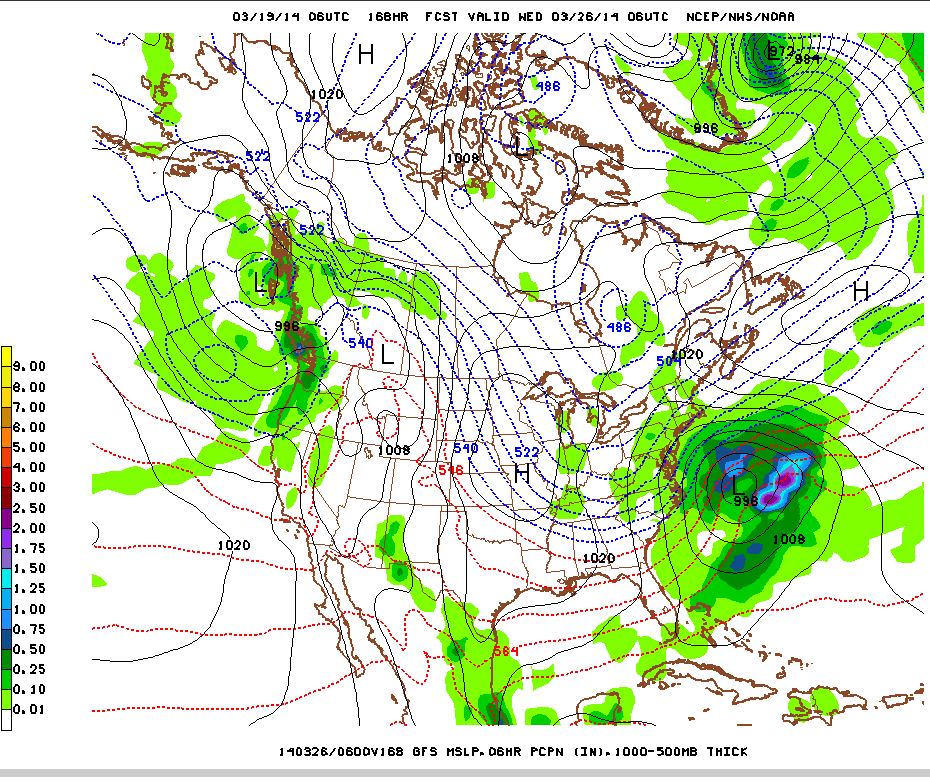
By Monday & Tuesday, we’re looking at temperatures only in the upper 30s, nearly 15 degrees below average. A storm system is forecast to form in the Gulf of Mexico and track across the Southeast, moving offshore of the Atlantic Tuesday. There is still uncertainty as to whether we’ll see precipitation, but if we do, temperature profiles will support snow showers/flurries.

Here’s the GFS Model’s forecast for the storm on Tuesday. It will pass well offshore of NYC, but may still precipitation bands may still rotate around it far enough north to impact us.

Untitled1

NYC Weather Update – Mar 17, 2014

We were fortunate to avoid a white Monday, as our friends to the south in NJ, DC, and Philadelphia got hit with between 4-9″ of snow during this last storm. Once again, despite temperatures being cold enough, we missed the area with higher moisture content, and dry air took the day, leading to some light flurries but no accumulation.

Check out the snow total map for the DC, Maryland, Delaware, and Southern NJ region below:

Screen shot 2014-03-17 at 3.18.53 PM

Looking ahead to the rest of the week, it looks like the formal start of Spring will bring a significant warmup for the area.

Tuesday – A sunny day as the departing storm and associated clouds clear out overnight. Good conditions for radiational cooling will mean a cold start to the day with lows in the mid 20s. However, ample sun will boost high temps up to near 40.

Wednesday – the next storm system approaches overnight Tuesday into Wednesday. A low pressure center will pass over the Great Lakes and to our north, with an accompanying trailing cold front. Temps ahead of the cold front will warm up to near normal for this time of year in the upper 40s, near 50. The cold front will bring along light showery precipitation during the afternoon Wednesday. See forecast diagram from the National Weather Service below:

Screen shot 2014-03-17 at 3.12.38 PM

End of the week will feature high pressure over the area with milder temps near the seasonal average of 50, and fair conditions. The next storm system is forecast to enter the area Friday night into Saturday.

Strong Pacific Storm Possible 10 Days

Parts of the west coast continue to see some abatement of drought conditions, with significant improvement for portions of Oregon and Northern California. Nine of twelve GFS model ensemble members are forecasting a strong Pacific storm coming ashore mid-week next week, which is good news for areas that could definitely use the rain. Below are two of the ensemble members. Note the fairly tight isobars denoting pressure, indicating a strong low pressure center.Screen shot 2014-03-17 at 3.11.55 PM

NYC Weekend Weather Update – Mar 15, 2014

Expecting a pleasant, mild, and mostly sunny day Saturday, temps in the mid-upper 50s – if you get a chance, definitely go out and enjoy the nice weather before a storm system enters the NYC region Sunday night into Monday night.

The mild temps today are as a result of southwest winds ahead of an approaching cold front. When the cold front pushes through, winds will shift to the west, ushering gusts up to 40mph and a significantly colder air mass.

Sunday – should be another mostly sunny day, though much cooler than today with highs temps only in the mid 30s. Sunday night, increasing chance of snow begins from south to north across the area. Overnight lows into Monday only in the mid 20s.

Monday – high temps will be right about freezing near the coast, and in the mid 20s in the interior. The setup for this storm system is very similar to the last snow storm (or non-storm) on Mar 3rd. Forecast models are suggesting that the bulk of moisture and favorable dynamics for heavy snow will remain offshore. Should this scenario hold, then we’d only expect to see a dusting to maybe an inch of snow in the city and Long Island, with negligible totals further north.

During the last storm, forecasters had difficulty resolving the uncertainty about exactly where the best conditions for heavier snow would exist. Again, this time, the line is quite close. A slight adjustment northward of the current forecast track for the low pressure system that is developing over the Gulf now could result in higher snowfall totals. See below how close the areas of darker blue representing moderate precipitation are to our area!

Screen shot 2014-03-15 at 11.29.13 AMTuesday – a dry and sunny day, but with temps still suppressed in the mid 30s in the city as a high pressure system temporarily sits over the NYC area.

Wednesday – the next low pressure system to impact the area will be moving in from the Great Lakes, with a low pressure center sliding to our north and a trailing cold front. Temps will climb into the low-mid 40s ahead of the cold front, so precipitation would be mixed to mostly rain.

Screen shot 2014-03-15 at 11.31.49 AM

The end of the week looks to be dry with highs near normal (around 47-49 deg at this time of the year).

NYC Weekend Weather Update & CA Storms – Feb 27, 2014

First up for the NYC area is a bitterly cold end to the work week.

A reinforcing arctic cold front is set to push through the area during the day today, perhaps spurring a few scattered moderate-heavy snow showers. Accumulation, if any, should be light. Behind this frontal boundary, a west wind between 15-20mph will usher in some of the coldest low temps we’ve seen in recent weeks. Lows in the city are forecast to be in the low teens, with zero to single digits in the interior. Wind chill values tomorrow morning will hover around zero.

Friday will be a sunny day with high pressure moving in. Despite the sunshine, temps will struggle into the 20s across the region.

Saturday, a weak frontal system moves through, but with dry atmospheric conditions, little if any snow is expected. Highs will be in the low-mid 30s.

Sunday-Monday, a prolonged winter weather event is forecast. The storm system currently impacting the west coast (see below) will move over the interior of the country, reorganize, and strengthen over the Midwest. This will lead to a stalled cold front draping across our region with multiple low pressure centers to slide along this front. One of these is forecast to develop into a potentially significant coastal storm. Models are coming into agreement that this storm center could pass close to the 40N 70W benchmark sweet spot.

The duration of the storm, starting Sunday night through Monday night means that it could result in significant snowfall, even with possible mixing in with sleet/rain near the coast during the day Monday. Still too early to tell how much snow – will keep monitoring the situation. High temps on Sunday will be in the mid 30s, then drop back into the low 30s for Monday.

Untitled

Too much of a good thing for California?

As I noted in earlier posts, and as has been broadcast by the media, California remains in the grips of a crippling drought. A strong pacific storm system is spinning up multiple bands of heavy precipitation during the end of this week. While that is some good news for the drought, the intensity of the rainfall could lead to mudslides, and localized flooding. The best news out of this storm is that elevations over 7000′ are expected to pick up as much as 1-3′ of snow, adding to a paltry snowpack thus far. Check out the graphic from the San Diego NWS station for a look at the heavy rain fall totals expected (5-7″ in higher elevations near the coast with south facing slopes!).

Untitled1

NYC Weather, The Week Ahead: Return of the Polar Vortex

A most unwelcome weather pattern in store for the NYC area this coming week: the polar vortex will make its return! Refer to my earlier post about the Arctic oscillation providing conducive conditions for the influx of frigid air into the Northeast for an in-depth analysis on this.

Sunday – another day of fairly mild temps near 50 ahead of the first of several cold fronts. This frontal system has the potential to bring some rain showers along the coastal areas and NYC proper, with some accumulating snow in higher elevations north and west during the overnight hours Sunday. Overall conditions are not that favorable for a high impact event, so I wouldn’t expect anything too out of hand.

Monday – with the passage of the cold front, a cooler day is in store with highs in the mid 40s and winds picking up from the northwest, 15-25mph and gusts up to 35mph. Monday night, the chill sets in.

Tuesday – highs will only top out around freezing in the city as the polar vortex takes hold. A dry day with increasing clouds as we watch the next storm system move in Tuesday night.

Wednesday – all eyes turn to the North Carolina coast as forecast models suggest the development of an area of surface low pressure that then tracks northeast into offshore waters of Long Island. As is generally the case this far out, uncertainty about the storm track, snow-to-liquid ratio, and available moisture make it difficult to be certain as to the impact of this storm. At the minimum, would expect something like 1-3″ in the city with snowfall totals increasing eastward. High temps again struggling to make it above freezing.

Screen shot 2014-02-22 at 9.05.23 PM
Possible nor’easter in store Wednesday

The remainder of the week will see the polar vortex become entrenched with high temps only in the mid-upper 20s. At least there aren’t any more storms on tap until the weekend!

NYC Noreaster Update – 6PM Feb 12, 2014

Everything is on track for this strong noreaster to begin moving into our area late tonight. NWS forecast office in Upton has upgraded all areas in the NYC metro to winter storm warnings ahead of the storm. The low pressure center responsible for this weather will move offshore of the Delmarva Peninsula and begin a process of rapid strengthening as its central pressure drops precipitously by 25mb.

Snow will begin falling over the area from south to north after midnight tonight. Heavy snowfall rates of 1-2″/hour are possible with a large scale snow band  forecast to develop due to the influence of a strengthening frontal boundary. By morning, NYC will pick up at least 3″ of heavy, wet snow, making for a messy commute. Snow will continue falling during the morning commute, heavily at times, limiting visibility. Snow transitions into sleet and possibly some rain around the coastal areas during midday. If rain mixes in, areas near the coast would see minimal additional snow accumulation during the day. If rain does not mix in, then another 6″ is possible.

Areas in the interior will see snow start later than NYC and the coast, but will continue to experience all snow or a sleet/snow mix during the day Thursday. These areas will pick up an additional 6″+ during the day Thursday, with another shot at picking up 6″ or more Thursday night as bands of snow continue to rotate around the center of the low.

As the storm departs to the east, it will continue to strengthen. The tightening pressure gradient will lead to stronger winds, with gusts as high as 40-50mph in some parts, leading to blowing and drifting snow. The heavy, wet snow associated with this storm has the potential to knock out power and collapse roofs already encumbered with accumulation from previous storms.


NYC Storm Update – Feb 11, 2014

There is increasing confidence that NYC will be seeing a high-impact snow storm Wednesday night into Thursday night. However, there are still discrepancies between different forecast models that are leading forecasters to not place too much confidence in overall snowfall totals. There are two main scenarios that could unfold: 1) the storm center takes a track closer to the coast, or 2) the storm center tracks further offshore.

In the first scenario, warmer air would be able to enter into coastal areas and lead to more rain, thus cutting down snowfall totals in NYC, Long Island, and coastal NJ, CT. In the second scenario, warmer air does not flow in as much. This would lead to higher snowfall totals for all areas of the NYC metro. With snow:water ratios about 8:1, and as much as .75-1.5″ inches of precipitable water available (moisture that can fall as snow, rain, ice, etc.), any small change in forecast track and temperature could lead to significant changes in the forecast total snowfall.

Current forecast:

Timing: accumulating snow will begin falling over the area, spreading from south to north, beginning Wednesday night. During the overnight hours into early Thursday morning, widespread totals of 4-6″ are possible. If the track producing a warmer temps verifies, then snow will mix in with rain along coastal areas during the day Thursday, while remaining all snow inland. A return to all snow will occur Thursday night as temps drop below freezing and the storm system exits to the northeast.

Impact: NWS is forecasting 6-8″ total snowfall for areas along the coast including NYC, with 8-10″+ in areas immediately north and west of the city. This is a total for Wednesday night into Thursday night. Thursday morning commute will be messy, with accumulating snow transitioning to rain making for a slushy mess in coastal areas, and all snow in the interior.

Screen shot 2014-02-11 at 6.27

NYC Snowstorm Update – Feb 11, 2014

UntitledSignificant winter storm is already underway for large parts of the southeast. Snow, and ice accumulation up to 5″+ in some areas before this storm moves in on the northeast.

Still a decent amount of uncertainty as to final track of this storm. If the storm takes a track closer to land, there will be more rain and less snow. If the center of the storm passes south of NYC near what is referred to as the 40°N 70°W benchmark, this will become an all snow or mostly snow event area wide.

With snow to liquid ratios between 10 and 15:1, even a slight deviation could mean dramatically different outcomes. The city has been consistently forecast to be on the cusp of the rain/snow line so final track adjustments are worth keeping an eye. Current NWS forecast thinking is for accumulating snow to begin falling overnight Wed through late Thurs morning. A changeover to rain is currently expected in NYC and coastal areas which would keep overall snowfall totals down. A change back to all snow would occur as temps drop later Thurs as bands of precip wrap around the center of the low departing east.

Temps today will remain chilly in the upper 20s, with sunny conditions. Overnight lows in the teens, and a similar day weather-wise Wed. Overnight lows Wed in the mid 20s, and hi temps Thurs (critically) just above freezing in this forecast. Warmer on Fri w temps nearing 40.

Details:
All reliable models point to a rapidly deepening low pressure center, with central pressure dropping from 992mb to 970mb in this Navy model forecast as the low moves from our area into New England. A mesoscale banding feature also develops, but final placement is uncertain. Right now, hpc is forecasting axis of heaviest snow from NE PA, northeast through NE NJ, western MA and into down east ME. 6-12″ could easily accumulate under this banding feature.

Details:

All reliable models point to a rapidly deepening low pressure center, with central pressure dropping from 992mb to 970mb in this Navy model forecast as the low moves from our area into New England. A mesoscale banding feature also develops, but final placement is uncertain. Right now, hpc is forecasting axis of heaviest snow from NE PA, northeast through NE NJ, western MA and into down east ME. 6-12″ could easily accumulate under this banding feature.

Storm Update NYC – Feb 10, 2014


NYC weather update (noreaster?): Still considerable variation between different forecast models in the resolution of the storm track for this upcoming coastal low. Model spread of about 100 mi during the critical forecast period. This could mean the difference between a large snowfall for all areas of NYC metro, or a rain/snow/sleet mix for the city & coastal areas, and all snow inland.

With this much uncertainty in the mix, it’s still hard to say with any confidence how much snow will accumulate. Operational forecasts from the NWS are mixing in rain at the moment during the day Thurs. More updates to come.

Temps tomorrow & Wed remain chill, below freezing in the upper 20s, with lows in the teens again in NYC and single digits further inland. Clear and sunny conditions for the most part until the storm rolls in.

1800437_818238196974_2044261127_n