Monthly Archives: April 2016

NYC Weather Update – Apr 26, 2016

There is a potential for strong to severe thunderstorms today, especially for areas south and west of the city today. Stormy weather gives way to calmer, cooler conditions Wednesday before another round of rain moves in late Thursday. Cooler temperatures prevail in the short to medium term.

Rest of today – the Storm Prediction Center has placed portions of the region under a marginal to slight risk of severe weather today. These areas are largely confined to those south and west of the city. A frontal boundary is draped from west to east across the area, such that portions to the east will be in colder air north of the frontal boundary, while those areas to the west will be in a warmer area south of it. Any strong to severe thunderstorms will be confined to areas that see the warmest temperatures today, where the spread in high temperatures could be over 25ºF from eastern Long Island to Central New Jersey.

In the city, expect high temperatures in the upper-60s to low-70s with a potential for thunderstorms, some possibly with damaging winds and small hail. These storms will be coming in two rounds, one around 11AM this morning (radar returns are already showing this batch of weaker showers), and the second, stronger batch coming around 3PM. Screen Shot 2016-04-26 at 10.19.47 AM Screen Shot 2016-04-26 at 10.20.01 AM

Wednesday – temperatures cool off considerably in the wake of these storms. High temperatures will be around 60ºF tomorrow with sunny skies.

Thursday – another cool day with high temperatures in the upper-50s and increasing clouds along with an increasing chance of rain during the day into the overnight hours.

Friday – high temperatures in the upper-50s to around 60ºF with partly sunny skies.

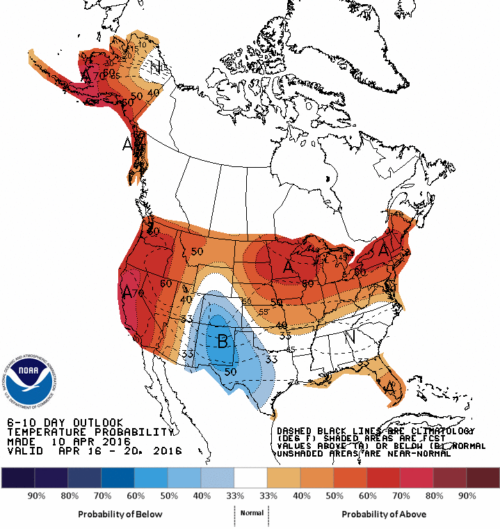
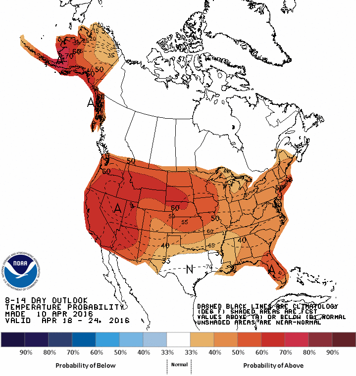
Below Normal Temperature Trend to Continue – Rain Needed

An upcoming series of storm systems moving over the region will lead to colder air being pulled in behind them. This will result in below normal temperatures for this time of year throughout much of the next two weeks.

610temp.new 814temp.new

Due to a long stretch of dry weather, many portions of the NYC region have fallen behind normal precipitation levels for this period of the year by considerable margins. Hopefully, the rounds of rain we are forecast to receive coming up will help to prevent drought conditions from redeveloping in the area before this growing season starts in earnest.

20160419_northeast_trd

NYC Weekend Weather – Passover Weekend – Apr 22, 2016

Showers and thunderstorms move through the region later today. The weekend begins with mild weather before a brief cool down on Sunday. Warmer temperatures arrive again to start the week before the next chance of rain Monday night into Tuesday.

Rest of today – mostly cloudy as a cold front approaches from the west. South-Southwest winds ahead of this front will bring warm air and raise high temperatures into the mid-upper 70s except south-facing shorelines. Rain from this system does not appear to reach the area until later this evening, around 6-7PM after which rain becomes steadier into the overnight hours.

Screen Shot 2016-04-22 at 9.51.36 AM

Saturday – clouds decrease as the storm system above moves off to the east. Temperatures a bit cooler in the low-mid 70s, but still a very nice day. Steady north wind will cool things off, and clear skies overnight will allow temperatures to drop back into the upper-40s for the city and even colder in the suburbs.

Sunday – with such a cool start to the day, temperatures will struggle to break 60ºF despite plenty of sun.

Monday – a shift in wind direction to the south with a high pressure system to the southeast means warmer temperatures Monday with high temperatures climbing back into the upper-60s.

NYC Weather Update – Apr 18, 2016

This week begins with weather more indicative of May, with warm temperatures in the upper-70s today and around 70ºF tomorrow before temperatures cool off a bit later in the week. Pleasant conditions all week as it seems spring has finally taken hold for good.

Rest of today – warm, with clear skies and high temperatures well above normal (by around 15ºF) near 80ºF in the city. Cooler along the south-facing shores of Long Island and warmer inland over New Jersey.

Tuesday – a cold front will pass through from the north overnight into Tuesday, but is not expected to bring any rain with it. This will result in cooler temperatures on Tuesday, with high temperatures peaking around 70ºF.

94fndfd_init_2016041812

Wednesday – a bit cooler with temperatures peaking around 60ºF with clear skies.

Thursday – increasing clouds with the next storm system approaching late in the week, temperatures will warm up into the mid-60s ahead of this storm.

NYC Weekend Weather – Apr 15, 2016

Hope you did your taxes early because you’re not going to want to be inside this weekend. The weather will be fantastic with lots of sun and warm temperatures. This span of beautiful weather continues right through the beginning of next week. Looking ahead, it is safe to say that we are out of the grips of winter for good.

Rest of today – clear with high temperatures around normal in the low-60s.

Saturday – high pressure dominates the region with more sun, and slightly warmer temperatures in the low-mid 60s.

Sunday – warmer, with highs topping off in the upper-60s to the low-70s.

Screen Shot 2016-04-15 at 12.43.22 PM

Monday – warmer still, with high temperatures in the low-70s generally.

NYC Weather Update – Apr 11, 2016

After a cold start to the first full month of spring, we’re finally turning the corner and headed into a gradual warming trend to end the month. This week looks good, with mostly dry weather except for Tuesday, and temperatures at or slightly above normal in the upper-50s to around 60ºF.

Rest of today – skies have been clearing up the past few hours, though there are more clouds to our west. However, no rain is expected to fall until much later in the overnight hours and temperatures should be pleasant in the mid-50s.

Tuesday – rain in the morning, cloudy and warmer with high temperatures around 60ºF.

Screen Shot 2016-04-11 at 12.44.13 PM

Wednesday – mostly sunny day with high temperatures again in the upper-50s to around 60ºF under the influence of a high pressure center.

Thursday – basically a copy of Wednesday, but perhaps a couple degrees warmer.

Friday – the streak of good weather continues, another nice day pretty much like Friday.

Warming Trend

Above normal temperatures are expected for almost the entire country, including the Northeast, for pretty much the remainder of the month.

610temp.new 814temp.new

NYC Weekend Weather – Apr 7, 2016

Wet, but much warmer weather today gives way to another blast of cold air this weekend. Light accumulating snow (1-3″) will be a real possibility Saturday and Saturday night before temperatures moderate back closer to season averages for this time of year to start next week.

Rest of today – cloudy, with gusty winds up to 40-50mph from the south and southwest. High temperature in the low-60s. Periods of rain with some thunderstorms possible this afternoon. The first batch of this rain will come in a line around 1PM this afternoon, with a second round of rain hitting later this evening at around 9PM.

Screen Shot 2016-04-07 at 9.43.29 AM Screen Shot 2016-04-07 at 9.43.54 AM

Friday – temperatures cool off into the mid-50s with a very small chance for lingering showers and mostly cloudy skies. Overnight lows will drop into the mid-30s.

Saturday – a reinforcing arctic front will sweep through during the day on Saturday, such that high temperatures will peak early in the upper-30s before dropping into the low-30s into the 20s overnight. Precipitation will start off as snow at the coast, transition to rain for a period during the afternoon, but then turn back to snow late in the day. When it all settles, we could have 1-2″ of snow on the ground here in the city.

99fndfd

Sunday – skies clear out with high pressure taking control after the storm passes on Saturday, but temperatures will be cold, only the mid-40s.

Monday – an advancing storm system from the west will shift winds to the south and allow for temperatures to rise back to seasonal averages in the mid-50s.

NYC Weather Update – Apr 4, 2016

I thought we had seen the last of the snow this spring, but winter stubbornly will not give up. This week, we’ll see the coldest weather we’ve encountered since the depths of winter, with low temperatures dropping into the upper-20s in the city and even teens for outlying areas. A brief warm up occurs this Thursday before the cold returns again.

Rest of today – windy with periods of rain in the city. High temperatures will likely top off in the upper-40s to near 50ºF. Temperatures plummet into the upper-20s following the passage of the cold front that’s responsible for this round of precipitation.

Tuesday – clear skies will belie the much below normal high temperatures for the day which will be only around 40ºF. A freeze warning is in effect for most of the coastal regions in the Tri-State area given the overnight lows that will be substantially below freezing.

Screen Shot 2016-04-04 at 10.11.54 AM

Wednesday – the high pressure pictured above will be in firm control Tuesday and overnight into Wednesday. A cloudless sky overnight will make for ideal conditions for radiational cooling, resulting in low temperatures again in the mid-20s. High temperatures will be warmer in the mid-40s with increasing clouds ahead of the next storm system.

Thursday – a surge of warmer air will accompany the next storm system to impact the area Thursday. This storm system will bring widespread rain and even some thunderstorms late in the day Thursday. High temperatures should reach well into the upper-50s and near 60ºF.

Screen Shot 2016-04-04 at 10.12.15 AM

Friday – following the passage of the storm on Thursday, temperatures cool off again into the upper-40s under mostly cloudy skies.

NYC Weekend Weather – Apr 1, 2016

It’s going to feel like a bad April Fool’s joke hit us this weekend when the weather turns to a locked in pattern of below average temperatures – cold enough at times to support snow, perhaps even enough to accumulate. Hard to believe that we almost hit 80ºF in February.

Rest of today – a potent storm system that pummeled large parts of the south with severe weather, including tornadoes, will be moving through the area this afternoon. We won’t see anything nearly as powerful as the storms that hit the south, but it does look like there will be two rounds of moderate rain with a few thunderstorms. The first batch looks to hit around noon and lunch hours, while the second arrives later this evening around 7PM. Gusty southwest winds up to 30mph ahead of the passage of the cold front responsible for these storms will bring temperatures well into the upper-60s and low-70s.Screen Shot 2016-04-01 at 9.49.35 AM Screen Shot 2016-04-01 at 9.49.53 AM

Saturday – much cooler with temperatures in the upper-50s to around 60ºF. A chance for scattered showers remains due to the approach of another cold front from the Great Lakes.

Sunday – we’ll begin to feel the chill in earnest on Sunday as temperatures drop into the mid-30s overnight from Saturday into Sunday. A polar vortex will be moving in over a large part of the northern United States. There could even be some snow showers in the city on Sunday morning before skies clear and winds pick up from the northwest into the 20-30mph range with clearing skies. High temperatures will only be in the mid-40s, nearly 10ºF below average.

Monday – a warm front preceding a low pressure system will move through Monday allowing for temperatures to rise into the low-50s, however, this will be accompanied by rain. Overnight into Tuesday, temperatures should cool enough for this rain to transition to all snow for a period.

A Cool April

The polar jet stream will be dipping well south of us during the medium term, allowing for a polar vortex to move over the region. This will lead to a cooler than average first half of the month, and possibly the entire month. Today might be the last day we see the 60s and 70s for quite some time, so go out and enjoy it while you can.

610temp.new 814temp.new off15_temp