Severe thunderstorms are approaching the area from our west. Several distinct bowing segments of severe thunderstorms have been making their way steadily towards our area from Central Pennsylvania since earlier this afternoon.
These storms have a history of producing damaging wind gusts and even a few tornadoes. Sundown over some of the areas under the current Severe Thunderstorm Watch areas in our region may weaken these storms, however, overall atmospheric conditions are quite favorable to the forward propagation of this line.
We had a nice couple days of seasonable, dry, and sunny weather this past weekend in the wake of Hurricane Arthur’s passage, but that came to an end yesterday and today. The high pressure that gave us the nice conditions moved to the southeast and out over the open waters of the Atlantic, merging with the semi-stationary Bermuda high. As you may know, this set up favors hot, humid temperatures all along the east coast, and we are no exception. Expect high temperatures to top out in the low-mid 90s today, with uncomfortably high humidity.
Wednesday – we may get some relief from the heat later today and overnight with a pre-frontal trough and scattered diurnal thunderstorms forming in the hot, unstable air. However, tomorrow will be more or less a repeat of today, with temperatures in the upper 80s to low 90s and muggy conditions.
Thursday – The cold front above won’t actually reach us until late in the day Wednesday, but when it does hit us Thursday, it will bring some chance for scattered thunderstorms and a slight drop in temperatures back down into the mid 80s.
Friday – amazingly, our streak of great weekend weather (with the exception of Arthur) is set to continue. Once the cold front clears us Thursday, we’ll see high pressure build in from the west Friday, which means some cooler winds and lower humidity airmass from Canada moving in. Temperatures should be milder, in the low-mid 80s Friday through the weekend.
Our next shot at precipitation will be late Sunday into the beginning of next week.
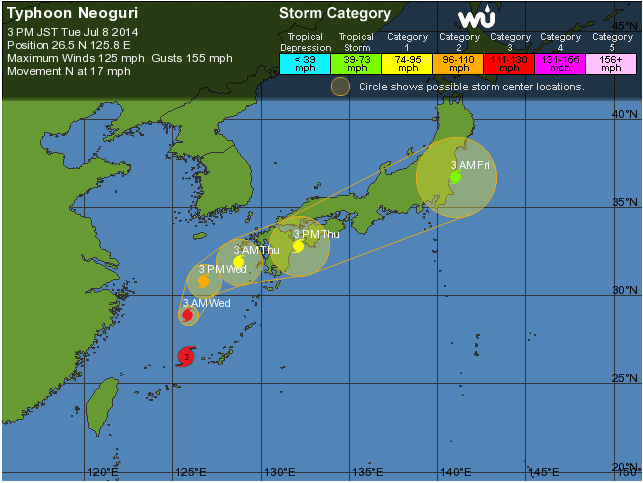
Despite the fact that Typhoon Neoguri shares a name with a well-known brand of packaged ramen, it certainly is no joking matter, as you can see from the impressive satellite image captured recently. Although the storm has weakened from a Category 4 Super Typhoon, it is still a powerful Category 3 storm currently churning up the East China Sea.
This storm is bad news for Japan, especially the large populations living on the southernmost home island of Kyushu. Forecasters believe Neoguri will continue to weaken rapidly under the influence of increasing wind shear, but it is still set to make landfall on Kyushu some time Thursday as a Category 1 storm. The mountainous terrain of Kyushu will likely provide orographic enhancement for the rain bands coming off of Neoguri (the upslope side of the mountains facing Neoguri’s onslaught will have the tendency of squeezing out precipitation from the rain bands).


