Temporary Changes to this Blog
Over the next few weeks, I’m going to take a break from my normal posts about weather in NYC and the region because I’m participating in the WxChallenge national weather forecasting competition. This is a course requirement for the final semester of the Undergraduate Certificate in Weather Forecasting program with Penn State University’s World Campus that I’m enrolled in. During the course of this competition, I will be providing forecasts of high temperatures, low temperatures, maximum sustained winds, and total precipitation for various cities in the challenge. The first of these cities will be Portland, Oregon – specifically Portland International Airport (KPDX). If events of particular interest, such as severe weather, tropical storms, or etc are forecast to occur in NYC, I will make special posts regarding such events.
Forecasting for KPDX September 25-28, 2018
Synoptic Set Up (The Big Picture)
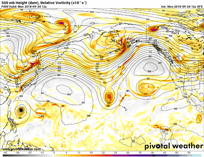
High pressure was located at the surface west of KPDX. A rex blocking pattern existed over the Pacific (a upper level high directly north of an upper level low, see animation below, the upper level high is west of OR/WA and shaded with some light blues, the upper level low just south of it shaded with oranges/reds). Some northeasterly winds were forecast during the forecast days, especially later in the day/overnight, which given the topography surrounding KPDX would lead to some downsloping. Still, northwesterly was forecast to be the predominant wind direction, which aligns well with climatological norms for September. A thermal low was mentioned to be in place through the mid-week period that would migrate daily from west to east.
Forecast Rationale
The synoptic set up favors little change in day-to-day conditions. Downsloping and the presence of a thermal low over the Willamette Valley suggest warmer than climatological and MOS (Model Output Statistics) guidance max temps. Despite mostly clear to clear skies throughout the forecast period, radiational cooling at night should be limited due to winds expected to be easterly overnight. When there are clear skies with no/calm winds, this allows infrared radiation to efficiently escape into space from the Earth’s surface, resulting in cooler temperatures when compared with a cloudy and/or windy night. Of note, easterly winds produce the fastest winds for KPDX due to some funneling effects from the Columbia River Gorge (think of this like blowing through a straw). This was referenced in the local forecast AFD. However, the MOS guidance didn’t really show a clear signal of wind directions favorable to strong funneling, so it would be unwise to go too much above guidance here. Late week cool down noted as the rex block breaks down and the upper low that was associated with makes its way towards the west coast. Exact placement/timing could bring some precipitation in the picture by the weekend and maybe early into week 2 forecast period.
Forecast Submitted
| Forecast Day | Max Temp (°F) | Min Temp (°F) | Max Sustained Wind
(knots) |
Precipitation (inches) |
| 09/25/2018 | 82 | 52 | 15 | 0.00 |
| 09/26/2018 | 82 | 52 | 11 | 0.00 |
| 09/27/2018 | 85 | 54 | 8 | 0.00 |
| 09/28/2018 | 83 | 55 | 6 | 0.00 |