This weekend, we’ll be watching for development of yet another nor’easter that could impact the region to start off next week. This would mark the third nor’easter in as many weeks, and put an exclamation point on a very active weather pattern. We also set our clocks forward with daylight saving time overnight between Saturday and Sunday. Enjoy more sun in the evenings!
Rest of today – clods and sun with a possibility for a spot flurry later in the day. High temperatures in the mid-40s.
Saturday – mostly sunny with high temperatures around average for this time of year in the mid-40s.
Sunday – another average day with sunny skies and high temperatures in the mid-40s.
Monday – things could get interesting as a developing low off the North Carolina coast works its way up the Eastern Seaboard. There’s a good deal of uncertainty at this time about the eventual storm track. Some models take this storm too far offshore to affect us, but notably the GFS has been on the western end of the forecast envelope. Some of its solutions would bring another significant storm with the possibility for more snow to the area Monday. Needless to say, this is situation that will bear monitoring over the weekend. High temperatures Monday will be impacted by the proximity of this storm. For now, forecasts call for a high around 40ºF with a chance of rain/snow.
The second week of March brings another nor’easter. The week will start off calmly with temperatures about average for this time of year. Tuesday night into Wednesday, a nor’easter will impact the region. This time around, the primary threat will be possible heavy snow rather than high winds. There are signals for yet another nor’easter next Tuesday as well!
Rest of today – decreasing clouds, high temperatures in the mid-40s with winds diminishing.
Tuesday – the veritable calm before the storm, a mostly sunny day with high temperatures in the mid-40s again.
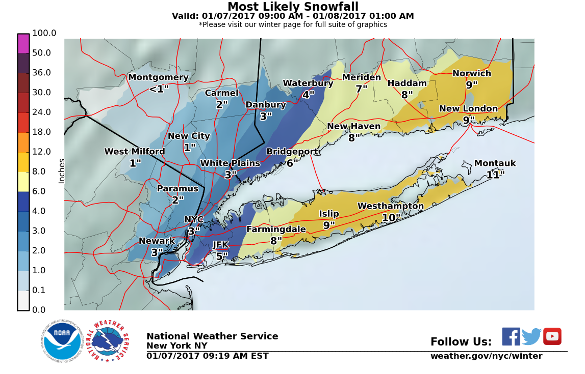
Wednesday – a low pressure system that tracks east from the Great Lakes will spawn a secondary coastal low offshore of North Carolina. This coastal low will steadily gather strength, aided in part by the presence of an upper-level jet streak and the divergence provided within the exit region of this jet. At this time, two main camps of models have the storm tracking either close to the coast or over the 40N 70W benchmark. The former solution would mean higher precipitation amounts but more potential for mixing at the coast due to the influence of warmer marine air wrapping in. The latter solution would likely yield all snow, but with less total precipitable water. Currently, forecasters are calling for between 5-10″ of snow and a winter weather advisory is in effect.
Primary low moving east from the Great Lakes region, secondary low formation off of the coast of the NC/VA border
High temperatures should top out in the upper-30s. The main snow event would occur Wednesday afternoon and overnight. Based on the NAM and GFS ensembles, it appears as of now that the highest confidence is for a 5-6″ event. Again, this could change with a shift in the storm track, and we won’t know where the heaviest bands of snow set up until the event begins.
NAM ensemble plume forecasts for snowfall totals in LGAGFS ensemble plumes forecast for snowfall totals at LGA
Thursday – unlike the last storm, this one will exit relatively quickly. This reduces the overall impacts for wind and coastal flooding. Thursday should be a day of improving conditions with partly sunny skies and high temperatures back in the mid-40s.
March arrives as a roaring lion this year with a powerful nor’easter impacting the region during the first half of the weekend. A variety of hazards from snow to high winds to coastal flooding will affect the area before this nor’easter meanders its way out to the open ocean. Behind this storm, the large scale pattern shifts and much cooler air rushes in, displacing unseasonable warmth with more average temperatures for the week to come.
Rest of today – rain and snow mixing. Little to no accumulation expected. Winds increasing from north to northeast winds 20-25 mph to 30-35 mph with gusts as high as 60 mph near the coast possible later today. Moderate coastal flooding possible over multiple tide cycles tonight, and Saturday. These tides will be higher than normal since they are falling on the full moon (spring tides). Temperatures will hold steady in the upper-30s.
Overnight, an inland low and coastal low consolidated offshore of the Northeast and the coastal low has already rapidly strengthened to a minimum pressure of 984 mb this morning. Two branches of the polar jet have phased together, providing the energy for this robust storm. As the storm continues to deepen, the pressure gradient between it and an area of high pressure over the Upper Midwest will continue to increase, leading to stronger winds. Onshore flow of these winds from the north and northeast over an extended period of time are expected to bring coastal flooding. Periods of moderate to heavy rain could lead to flooding in general. Although the cold, northwest flank of the storm as it exits to the east will support snow (with its cold conveyor belt), accumulations at the coast should be limited. This is another story inland where heavy snow is expected in the Lower Hudson Valley.
Saturday – periods of moderate to heavy rain with snow mixing in continue overnight, but should taper off by the morning. Winds will diminish from the 30 mph range with gusts up to 55 mph overnight but will remain stiff in the 20-25 mph range from the north. Much colder feel with highs in the mid-40s under partly sunny skies.
Sunday – much nicer day, winds finally abating with high temperatures in the mid-40s and mostly sunny skies.
Monday – sunny, with high temperatures in the mid-40s.
Another rainy weekend on tap for the Tri-State area as a Nor’easter takes aim at the Mid-Atlantic and New England just in time to put a damper on Mother’s Day plans. Luckily for us, rain on actual Mother’s Day should be limited to the morning hours. Next week, we’re looking forward to a big warm up in temperatures.
Rest of today – partly sunny with high temperatures topping out in the low-60s.
Saturday – a Nor’easter moves in on the area overnight into Saturday. Expect raw, windy, rainy conditions for the duration of the day. There could be periods of moderate to heavy rain along with east/east-northeast winds in the 15mph with stronger gusts. High temperatures with the onshore flow, clouds, and rain only expected to reach the low-50s.
Sunday (Mother’s Day) – rains clear up earlier in the day, but we’re still left with a windy and cloudy day. The tradeoff is warmer temperatures in the mid-60s.
Monday – partly sunny skies with improving conditions and high temperatures in the mid-60s.
Warmup Ahead
Starting Tuesday, temperatures begin to warm up significantly with a shift in our weather pattern. A summer-like Bermuda high sets up and pumps in warm air from the south into the area, resulting in temperatures above to well-above normal (some 80s possible late week).
Classic major nor’easter to bring blizzard conditions to a large swath of the Northeast Tuesday just days from the official start of spring. Areas in and around NYC likely to see snowfall accumulations of over 1 foot, locally higher. This may end up being one of the biggest snowstorms/blizzards in history for the month of March in NYC.
Rest of today – the proverbial calm before the storm. Mostly sunny, cold, with high temperatures in the low-30s.
Tuesday – a major late season nor’easter will bring heavy snow and blizzard conditions to the area. Blizzard warning in effect for the entirety of Tuesday. Snow starts falling overnight into Tuesday. Heaviest snows forecast to begin around the morning rush and continue through most of the day. Blizzard conditions expected on the coast with steady north to northeast winds 30-35mph and gusts over 45mph. Visibility near zero at times. High temperatures at or below freezing. Widespread accumulations over 1 foot and approaching or exceeding 18″ expected around the NYC metro area. Details on the storm at the end of this post.
Wednesday – lingering chance for snow showers early with wrap around moisture on the backside of the departing nor’easter. Mostly cloudy with a high near freezing.
Thursday – skies clearing, high temperatures in the low-mid 30s.
Major Blizzard to Impact the NYC Region
Winter Storm Stella, as the Weather Channel refers to it, is set to bring widespread heavy snow to the area beginning overnight Monday and continuing throughout the day Tuesday.
Impacts – Snow accumulations over 1 foot, in many cases approaching 18″. Locally higher amounts, with some areas possibly approaching 2 feet. Heavy snow and blowing snow during the day Tuesday. Snowfall rates 2-4″ per hour and possibly higher in the heaviest snow bands possible. Thundersnow may accompany the strongest snow bands. Blowing and drifting snow with steady northeast winds 30-35mph and gusts 45-50mph will contribute to blizzard conditions with near zero visibility at times. East and northeast facing shorelines may experience moderate coastal flooding during high tide cycles. Heavy, wet snow at the coast combined with high winds may lead to power outages. Hazardous travel conditions, severe disruptions to aviation likely. High confidence in storm total snowfall at this point, but there is still uncertainty about whether and where mixing could occur.
Timing – Snow begins early in the overnight hours Tuesday. Light accumulations of 2-4″ possible by daybreak. Heavy snow likely beginning during the morning rush hour and continuing through most of the work day, as well as into the evening rush hour. Winds quickly intensifying from the morning and staying steady through the evening hours. Heaviest snow tapers off in the early evening hours, but snow showers could continue overnight. Winds remain strong overnight into Wednesday. Conditions improve going into the morning Wednesday.
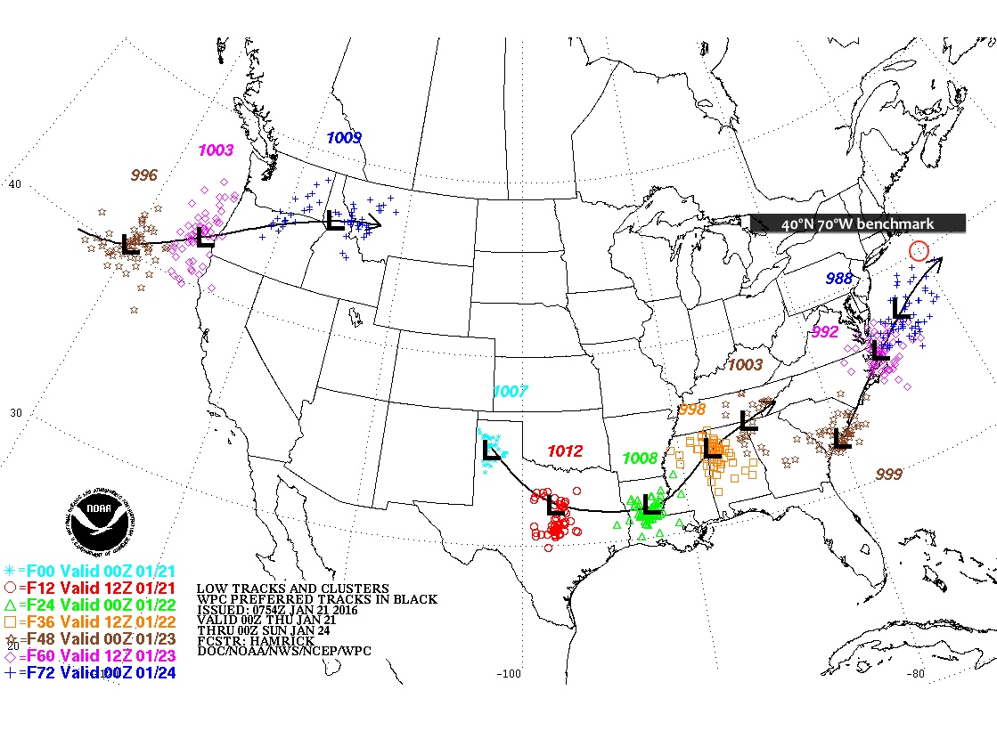
Discussion – an area of low pressure that had its origins in the Pacific has made its way across the northern US, impacting the Northern Plains and Upper Midwest with snow. This storm system will phase with a secondary, coastal low pressure system that is currently moving up the coast from the Southeast. As these storms merge, the coastal low will undergo rapid intensification and cyclogenesis, becoming a strong Nor’easter. This storm will be drawing on subtropical moisture, and will encounter an airmass that will be quite cold due to the presence of an Arctic high pressure system prior to the storm’s passage. These ingredients will set the stage for a classic major blizzard for the Northeast late in the winter season, only days from spring.
As always, uncertainty remains about the exact location of the heaviest snow bands with this storm. Areas that are impacted by these bands can easily rack up several more inches than surrounding areas that are spared. The storm is expected to track west of the 40°N/70°W benchmark. However, during the last model runs, the storm track has trended north and west, increasing the chances for the city itself to see the heaviest snow, in addition to areas north and west. If this track shifts west some more, warmer air off the ocean wrapping into the core of the storm from the south could induce mixed precipitation with rain cutting down on totals in the city and Long Island. If the track shifts east, heavier snow would fall over points east of the city.
Overnight, forecast models shifted the track of the ongoing Nor’easter further west. This has implications for snowfall totals across the region.
Snowfall Totals
These have been bumped up for the city, which is now expected to receive 2-5″. The potential exists for more. Winter storm warnings now extend as far west as Nassau County, with points further east receiving as much as 7-12″.
As always with Nor’easters, even as they are ongoing, considerable uncertainty remains a factor. With these storms, one or more banding features will develop and circulate around the center of the storm as it progresses northeast. The number, extent, intensity, and western limit of advancement of these banding features ultimately determines what areas get the most snow. Within these bands, snowfall rates could easily reach 1-2″/hour. West of the western limit of the progression of these bands, snowfall totals will drop precipitously, such that a distance of 10 miles could mean the difference between 2″ and 6″+.
Timing
You can already see the radar signatures of two bands of moderate to heavy snow spawned by this storm. One of these bands is currently pushing its way west through Long Island, while another progresses towards shore. Within these bands, travel conditions will rapidly deteriorate while accumulations rack up.
Looking ahead to this afternoon, it would appear that the heaviest snow will fall in the city around 2PM, or the early afternoon.
The big weather news for the first full weekend of the new year is the deep Arctic chill that will be gripping the area. We should narrowly miss the core what would have been the first substantial Nor’easter of the season Saturday. The chill lasts through the beginning of next week when temperatures rebound back to above normal levels.
Rest of today – cold, with a mix of clouds and sun and a high temperature in the mid-30s. Wind chills in the low-20s.
Saturday – an uncertain scenario unfolds with the Nor’easter mentioned above. The one thing that is certain is that temperatures will be plenty cold to support all snow with highs only in the upper-20s. Two of the main forecast models continue to show a sizable spread in terms of how far east this storm tracks. This will ultimately determine whether portions west of Eastern Long Island see anything more than than a couple inches of snow. The cutoff between heavier snow and a light coating looks to be quite sharp also.
Sunday – overnight lows this weekend will be chilly, only in the upper-teens. Sunday, the wind picks up as the pressure gradient between the Nor’easter and high pressure building to the west increases. High temperatures will again only range in the upper-20s.
Monday – sunny, but still cold with a high temperature right around freezing.
Drought Update
Recent storms have brought beneficial rain and snow to the state and has helped alleviate some of the worst drought, while also staving off the redevelopment of drought in some areas. The cold temperatures have also been helpful in reducing evaporation from the soil. There’s almost no extreme drought left in the state, though most of Downstate remains in an area of severe drought.
Meteorologically, March is a month of highly changeable weather that can swing from one extreme to another. Thus far this month, we’ve seen snow, and record warm temperatures near 80ºF. This week is no different, and it ends with the possibility for a significant coastal storm that could bring accumulating snow to the region to ring in the official start of spring!
Rest of today – warm, with partly sunny skies and high temperatures in the mid-60s. An unstable atmosphere looks primed to spawn a few scattered thunderstorms. Atmospheric dynamics are supportive of strong wind gusts and possibly small hail with any storms that form this afternoon. Some of these storms could approach severe limits. Based on the latest High Resolution Rapid Refresh model output, there look to be two batches of storms, one impacting the region around 2PM, then again around 5:30PM. At the time of this post, two storm cells were moving slowly east over southern Bergen County and the western Bronx respectively.
Friday – temperatures cool off into the low-mid 50s tomorrow, with a slight chance again for some afternoon showers, though nothing quite as significant as today.
Saturday – an area of polar high pressure will move over southeastern Canada, setting the stage for the winter storm Sunday. Saturday, however, will be a pleasant, sunny day, but temperatures will be below average in the low-mid 40s.
Sunday – all eyes turn to a developing coastal storm/Nor’easter. Forecast models are having a rough time handling this storm, with wide variances noted among some of the models from day to day. Given the uncertainty at this time, only a couple days before the expected onset of the storm, it is difficult to guess at the snowfall accumulations from this storm. One thing that is well understood at this point is that temperature profiles will support a primarily snow event, with some rain mixing in at the coast. High temperatures Sunday will struggle to hit 40ºF. Snow should begin in the morning, mixing with rain in the afternoon Sunday afternoon before transitioning again to all snow overnight. A slight variation in the forecast storm track either west or east could result in dramatically different snowfall totals – more updates to come.
Monday – temperatures rebound back into the mid-40s under partly sunny skies following the passage of this late season snow storm.
You’d be forgiven if you didn’t believe that a record-setting Nor’easter blizzard happened less than a week ago. A week of much above average temperatures and warm weather has quickly melted more than half of the snowpack that was left after the blizzard dropped 26.8″ (.1″ short of the all time record) in Central Park, breaking the single day storm total snowfall record with a new high of 26.6″. Except, of course, those huge snow mounds that are trapping your parked car. Warm weather, with high temperatures near or above 50ºF this weekend means that even more of this snow will melt away. Whatever’s left will likely be completely washed away mid-week next week when we’re expected to hit temperatures near 60ºF with thunderstorms possible.
Rest of today – mostly cloudy with a high near 40ºF. A passing rain/snow shower caused by a weak passing disturbance in the upper atmosphere is possible this afternoon around 1PM.
Saturday – brief clearing caused by an area of high pressure overnight will give way again to increasing clouds with high temperatures around 40ºF again.
Sunday – the high pressure moves quickly off to our east Sunday, allowing for clockwise return flow from the southwest to bring in warmer temperatures in the upper 40s under partly sunny skies.
Monday – warm temperatures continue with highs topping out around 50ºF and partly sunny skies.
Cooldown Coming
Don’t get too used to the warm temperatures because after mid-week next week, cold air returns to the Eastern United States for a period.
Blizzard Brings Drought Relief
One of the best parts about this blizzard was that it brought along some much needed precipitation precisely to areas of the region that most needed it. As you’ll see below, since the blizzard past the area of New York State experiencing moderate drought has decreased from 6.80% to 2.04%, largely because areas of moderate drought in the NYC region and Long Island have gotten slammed with huge amounts of snow that will be replenishing the local watersheds as it melts.
All eyes turn towards this weekend’s Nor’easter which will bring us the most snow we’ve seen since last winter. Confidence is growing that NYC and points south could receive over a foot of snow by Sunday. In addition, forecasters anticipate that this storm will bring sustained winds of 30mph to coastal areas with gusts as high as 40-60mph leading to whiteout blizzard conditions. However, it is important to not, even at this point, 48 hours from the start of this event, that a good deal of uncertainty remains about these forecast snow totals.
Rest of today – mostly clear with high temperatures reaching into the mid-30s but a northwest wind in the 15mph range making it feel colder.
Friday – slightly cooler with highs in the low-mid 30s, clouds I increasing through the day as the headline storm for the weekend approaches.
Saturday – snow should begin falling from southwest to northeast overnight Friday and continue throughout the day Saturday. Sustained northeast winds 25mph-30mph could lead to drifting and blowing snow, making for hazardous teavel conditions. Some potential exists that enough warmer air wraps into the storm off the Atlantic that some areas see a changeover to a rain/sleet/snow mix in the afternoon before transitioning back to all snow Saturday night. Total daytime accumulations are currently forecast between 3-7″. Overnight accumulations could be in the 4-8″ range.
Minimum snowfall for this Nor’easterMost likely snowfall totalsMaximum snowfall possible with this storm
Sunday – some lingering snow showers are possible Sunday morning but conditions should improve rapidly as cloud cover decreases with the storm exiting to our east. High temperatures are expected to be in the mid-30s.
Monday – warmer with high temperatures in the mid-30s and sunny skies.
Complicating Factors for Forecasting the Nor’easter
Model divergence – European models favor a solution that has the storm moving quicker and further south than US based models. This scenario would result in minimal snow for NYC, hence why the minimum snow forecast is only 2″.
Unpredictable snow bands – as we are all too aware from last year’s fiasco of subway shutdowns in anticipation for a blizzard that didn’t materialize, when it comes to Nor’easter type storms, where, when, and for how long deformation banding features (heavy bands of snow) set up will make or break a snowfall total forecast in either direction. However, these types of mesoscale banding features are not easy to predict with confidence before they actually start forming. Should parts of our region fall under one of these banding features where snow could be falling at rates of 1″+ per hour, you could easily see total snowfall forecasts be shattered.
Intrusion of warm air – if enough warm air works its way into this storm off the warm waters of the Atlantic (where above normal temperatures thus far this winter have kept the sea surface temperatures abnormally warm), then some areas could see a rain/sleet mix for periods of time. Forecasters are overall confident the window for this mixing is small enough that overall totals won’t be dented too much, though.
The closer this storm center tracks to the 40ºN 70ºW benchmark, the better the chances become for our are to get a lot of snow. Climatologically, Nor’easters that track closest to this benchmark have been the biggest snowmakers for the NYC region.


