For the remainder of today, temperatures will be in the low-mid 70s. A cold front is forecast to pass through the region later this evening into the overnight hours. Ahead of the frontal boundary, some scattered showers and a few thunderstorms are possible during the afternoon hours. Coverage will be sparse and any storms should be short in duration.
Saturday enough instability may linger in the wake of this cold front to allow for the development of PM pop up thunderstorms/showers. Again, coverage will be widely scattered and intensity of these storms would not be too great. Otherwise, partly cloudy with high temperatures will be slightly warmer in the mid-upper 70s.
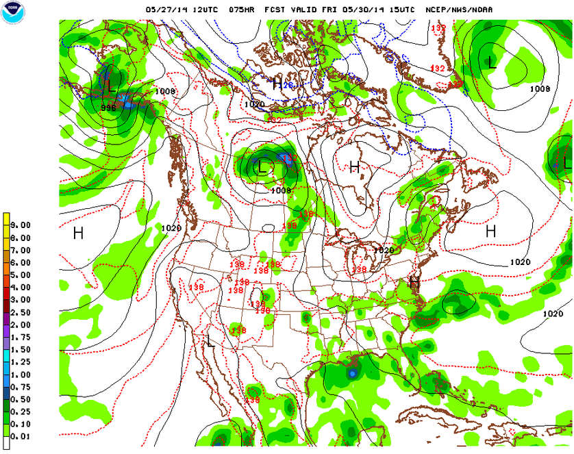
Sunday will be the best day of the weekend with high pressure beginning to build into the area. This high pressure center is forecast to sit to the south of us, allowing a warmer airmass to circulate clockwise around it. This should translate to warmer temperatures in the upper 70s to low 80s (especially inland) across the area. Fair weather with mostly sunny to clear skies.
This warm trend should continue into Monday of next week, when highs again will push 80n across the area under mostly sunny skies. Next chance at rain will be Tuesday.
What fantastic weather for the Memorial Day weekend! We topped off in the mid-80s across the area yesterday, and we’re likely to see another day with temperatures in the mid-upper 80s across the region (esp in interior portions of New Jersey).
Sadly, our stretch of summer-like temperatures is about to come to an end as a backdoor cold front (a front that does not approach from the west like most fronts do over this area) approaches the area from the north. Ahead of this cold front, temperatures are in the mid-80s and there is robust moisture in the atmosphere. This will provide the right ingredients for the possibility of severe thunderstorms later this afternoon and evening.
Possibility of Severe Thunderstorms This Afternoon
Current thinking is that these storms approach the NYC metro around 4-7PM during the evening rush hour. The Storm Prediction Center has placed NYC, western Long Island, Northern New Jersey, and much of the Hudson Valley under a slight risk area for severe weather this afternoon. By the way, slight risk in this context does not indicate that storms which occur will not be that severe, rather, it is denoting that the probability for severe storms is on the low side, and that coverage is not expected to be widespread. Just so you all are clear, the National Weather Service defines a severe thunderstorm as producing one or more of the following:
Wind gusts greater than 58mph
Hail greater than 3/4″ in diameter
A funnel cloud or tornado
A severe thunderstorm or tornado watch means that conditions are favorable over an area for the development of these types of weather hazards, however, no immediate threat has yet been identified. A warning means that a severe thunderstorm or tornado is imminent or already ongoing, which is understandably a much more dangerous situation. Anyway, the most likely threat for our immediate area are damaging wind gusts and hail, although a few isolated tornadic supercells cannot be ruled out.
Storm Prediction Center Day 1 Convective Outlook – we are in the slight risk area highlighted in yellow
Wednesday – by tomorrow, the cold front responsible for the possible thunderstorms later today will have moved through our area, however, there is still a chance for lingering showers on the backside of this frontal boundary. Also, since this is a backdoor cold front, temperatures will be significantly cooler tomorrow than today with an onshore easterly wind keeping high temperatures only in the mid 60s (about 20 degrees cooler than today).
Thursday – an area of high pressure will build into the area, but due to its position to our northeast, it will also continue to usher in onshore easterly/northeasterly winds that will keep our high temperatures below normal in the upper 60s. Otherwise, it will be a nice, sunny day.
Friday – another cold front will approach the region from the west and bring in the possibility for afternoon showers and thunderstorms. Slightly warmer with cloudy conditions and a high temperature near 70.
Saturday – high pressure will once again build in across the region and remain in place through the weekend. Therefore, am expecting pleasant, sunny conditions with about average temperatures in the mid-70s.
About that meteor shower… so as it turned out, the Camelopardalis meteor showers were a dud. Astronomers may have miscalculated the timing and/or amount of debris accumulated. Hey, it was the first time this particular shower was supposed to go down, so I guess you can’t blame them for not getting it right.
Just a quick update on your Memorial Day Weekend weather.
Saturday, still looks like there’s a chance for showers and isolated thunderstorms in the NYC metro area in the afternoon hours of Saturday. High temperatures will be mild in the low 70s under mostly cloudy skies.
In Oberlin, temperatures will be around the same in the low 70s, but skies will be clear and sunny.
Sunday will see clearing skies for the NYC metro area and warmer temps in the upper 70s and even low 80s particularly inland. Cooler at the shore with some (especially the south facing shore of Long Island) with a sea breeze and highs in the low-mid 70s. Still, an all around excellent beach day.
Oberlin will remain sunny with clear skies and highs in the upper 70s.
Monday will be the warmest day of the weekend with highs in the low 80s in the NYC area and mostly sunny skies.
Oberlin may see some clouds building in over the course of the day with an approaching storm system, but not expecting any rain. Highs in the upper 70s.
Visibility for Tonight’s Meteor Showers
Again, it is looking like the NYC area will miss out on the chance to see these meteor showers with cloud cover expected to be widespread. Good viewing for Oberlin though!
Cloud cover forecast for select locations (blue line). Red box indicates best viewing window for the meteor showers.
Today was an active weather day for the NYC area, particularly over New Jersey and upstate. A funnel cloud was spotted up in the Albany area, and a few severe thunderstorms exhibiting strong rotation (the strongest thunderstorms-supercells-often feature a single internal circulation called a mesocyclone) formed ahead of a cold front that’s still slowly pushing its way over western New Jersey. Some of these storms produced large hail over interior parts of the NYC metro area.
Friday there will continue to be a risk for thunderstorms during the afternoon hours, otherwise it should be a mostly cloudy day with his right around 70.
In Oberlin, tomorrow should see skies gradually clearing with his in the mid-upper 60s.
NAM model simulated radar image for 5PM EDT Friday, May 23, 2014
Saturday still cannot rule out a lingering risk of thunderstorms and showers in the PM hours on Saturday as shortwaves (impulses of energy) continue to spin around the backside of the departing low pressure system that’s brought us this period of unsettled weather. Highs will again be around 70, depending on if breaks in clouds develop.
By Saturday, skies should clear out over Oberlin, allowing temperatures to rise into the low 70s.
NAM model simulated radar image for 2PM EDT Saturday, May 24, 2014
Sunday and Monday are still on track to be the best days of the Memorial Day weekend with temperatures in the upper 70s Sunday and low 80s Monday.
Camelopardalis Meteor Shower Visibility
Now about that meteor shower, will you be able to see it in NYC? Sadly, the answer is probably not, due to a forecast that calls for mostly cloudy skies. With cloudy conditions, light pollution is amplified as the light cast off from the city gets reflected back down even more. It will be a different story for Oberlin, though, where skies are forecast to clear due to the influence of building high pressure well before the anticipated peak of the meteor showers.
NWS hour by hour graphical forecasts. Red boxes indicate the forecast peak for the new Comet 209P/LINEAR Camelopardalis meteor shower. The blue line represents the percentage of the sky that’s forecast to be covered with clouds.
The Storm Prediction Center in Norman, OK has placed western portions of our region under a slight risk for severe weather this afternoon, with the primary threat being damaging winds and hail.
Mid-upper level conditions are favorable for the development of thunderstorms with some rotating updrafts. Unidirectional winds at various levels, as well as wind speed shear, could impart enough rotation on storm cells to cause marginally severe wind damage and some hail. The highest potential will be over Eastern Pennsylvania and New Jersey where sufficient solar heating could produce CAPE (Convective Available Potential Energy, measured in joules per cubic kilogram) values of between 1000-1500 J/kg^3.
Storm Prediction Center in Norman, OK has placed western portions of our region in a slight risk area for severe weather this afternoon
A small cluster of thunderstorms is already initiating along the western New York/Pennsylvania border ahead of a weak cold front. These storms should expand in coverage and increase in intensity as skies are clear ahead of the frontal boundary, allowing for a good influx of energy for storms to feed off of. The current thinking is that isolated severe thunderstorms reach our region by around the 4-6PM time frame. The chances of these storms remaining severe over NYC and coastal areas is low, since there will be a stabilizing influence from the cool marine layer offshore.
Weather conditions will gradually deteriorate through the course of the day today as an approaching storm system draws closer to our area. Cloud coverage, scattered showers, and possible thunderstorms associated with a warm front should increase in coverage during the course of the day. High temperatures should be on the mild side in the mid-70s.
Thursday – as of now, the National Weather Service calls for the aforementioned warm front to approach but not clear our region by Thursday morning. As such, cooler southeast and easterly winds off the ocean will keep temperatures on the cool side with highs only in the mid-upper 60s. There will be a persistence chance for showers and thunderstorms as multiple impulses of energy ride up and along the frontal system, with a break probably occurring between early Thursday morning and later Thursday afternoon/evening.
Friday – in NYC, although the warm and cold fronts associated with this latest storm are forecast to have cleared through the area by Friday, an upper level low situated over the Canadian Maritimes will continue to allow impulses of energy (shortwaves) to rotate into our area providing the spark for a continued chance of showers and thunderstorms, especially Friday afternoon and evening. This upper low will be slow to move east due to a strong blocking “omega” high pressure center located over the central North Atlantic. High temperatures will again be around the upper 60s.
For Oberlin, conditions will begin to improve earlier with the chance of rain ending by Thursday, partly sunny skies Friday with gradual clearing and highs in the upper 60s.
NAM output simulated radar image for Friday at 2PM EDTGFS model output of 500 mb heights and absolute vorticity for Friday at 2PM EDT
Saturday – we’ll see an tenuous area of high pressure trying to build in from our west. However, there may still be a marginal chance of PM showers. Otherwise, expect gradually improving conditions with temperatures climbing back up into the low 70s.
Sunday and Monday (Memorial Day) – These will be the best days of the weekend with dry, mostly sunny, and warm conditions. High temperatures will continue to climb into the mid-upper 70s Sunday and possibly topping 80 Monday (this applies to both Oberlin and NYC). Next chance at rain will be Tuesday.
A New and Spectacular May Meteor Shower? – About Comet 209P/LINEAR & Camelopardalis
A friend of mine brought to my attention that a newly discovered and possibly brilliant meteor shower is forecast to take place in the early morning hours of Saturday, May 24th.
In brief, Earth is forecast to pass through the debris trail of a comet “Comet 209P/LINEAR” (discovered in 2004) during the overnight hours Friday into Saturday. Researchers are forecasting that the debris trail Earth passes through is one that has accumulated dust from as early as 1800 to 1924. As such, expectations are that we could see about an average of 200-400 meteors an hour (some estimates call for a meteor storm of 1000 meteors an hour!), i.e. between about 3-7 meteors per minute. Furthermore, the setup for this event is such that Southern Canada and the East Coast of the U.S. are ideally positioned to view this event. In the image below, the red line represents the forecast position of the radiant line (point from which meteors appear to emanate and where you would see the highest number of meteors), note that this line runs almost direct over Washington DC. Also, notice that the moon is in waxing gibbous phase, reducing its potential to overpower the meteor shower.
Timing and Visibility
The forecast zenith of this meteor shower is between 2AM-4AM Eastern Daylight Savings Time on Saturday, May 24th. Right now, the forecast for this time window calls for mostly cloudy skies over NYC as well as points east and north (i.e. New England). Partly cloudy skies are forecast the points further south and west (i.e. along the Jersey Shore, Washington DC/Northern, Eastern Virginia, Western Pennsylvania), with the best viewing conditions being in the DC metro area and Eastern Virginia where mostly clear skies are forecast. A word of caution: cloud cover forecasts even this close to the day of are notoriously difficult to pin down due to the fact that even small changes in initial conditions can lead to large shifts in a forecast. However, with high pressure building over the east coast throughout the course of the weekend, we should have generally good chances to view this shower.
My recommendation is that you go check this out in an area with minimal light pollution if you can. I think we’re in for a what I hope will be a good show!
Where to Look
The radiant point for this forecast meteor shower will be situated in the relatively obscure constellation Camelopardalis (named by the Romans for a hybrid animal that looks like both a camel and leopard, now known as a giraffe). As you’ll see below, this constellation is located slightly below the North Star (Polaris), and a bit to the right of the Big Dipper.
You can read a more in-depth analysis of this meteor shower here. I’ve grabbed and edited a couple images from this entry.
All preliminary indications are that this Memorial Day weekend should see fairly good weather, as you can read in the detailed discussion below. First, for your work week forecast:
For the remainder of the day today, there is a slight chance of a pop up shower or thunderstorm as cumulus clouds continue to build. This risk will cease as the sun begins to go down, and cuts off the heat source for these clouds. Overnight lows will fall into the low 50s in the city (not as cold as last night, as some clouds are expected to stick around early and stunt the potential for good radiational cooling), with 40s in the interior.
Tuesday will be the best day of the week, with high pressure briefly building in from the west. This will lead to mostly clear skies and warm temperatures in the upper 70s (also partially due to an incoming warm front).
Beginning Wednesday, we will see a period of unsettled weather as a relatively slow moving storm system approaches. This system will develop over the Great Lakes, and a warm front is forecast to be approaching our area during the day Wednesday. There will be an increasing chance of showers throughout the day as the warm front nears, with the best chance for precipitation in the late evening and overnight hours. Temperatures will be slightly lower than Tuesday in the mid-70s.
HPC’s Day 3 forecast for the US
Thursday there is a bit of uncertainty regarding the eastward progression of the warm front mentioned above. If the warm front has already passed over us, then we’ll be in the warm sector between the warm front and approaching cold front. This would lead to favorable conditions for some thunderstorms. Otherwise, we would expect mostly cloudy skies and a chance for more showery precipitation. High temperatures will be similar to Wednesday.
Friday, with the cold front Thursday having moved through and high pressure slowly building in, we would expect a good day weather-wise. However, as you see in the following image, the center of the now occluded low pressure is forecast to remain nearly stationary off the coast of New England. This is due to a blocking high over the North Atlantic (not pictured). Therefore, a chance of showers is forecast for both Friday and Saturday, with skies gradually clearing from mostly cloudy to mostly sunny Saturday. High temperatures Friday is forecast to be in the low 70s.
Now, the all important initial weekend forecast: as depicted above, high pressure building over the Great Lakes should progress generally southeast towards the Carolinas during the weekend. This should translate into improving weather each day during the weekend and increasing temperatures. Saturday, Sunday, and Monday should see high temperatures climbing from the low to mid 70s, and skies clearing to become mostly sunny.
For those of you reading this forecast who are traveling towards Oberlin and points west, the forecast for those parts is actually even better than for New York City in terms of sunshine, although, as you know temperatures will be slightly cooler in Ohio than here.
First for weather headline that will be dominating today: the storm system that is set to bring us heavy, potentially flooding rain later today and into the overnight hours. Currently, temperatures in our area are generally in the mid-upper 60s with a strong south to southeasterly wind. This is leading to an influx deep moisture ahead of the approaching cold front. We are firmly entrenched in what meteorologists refer to as a warm sector. This will provide the necessary conditions for heavy rain and some possible embedded thunderstorms to form later.
NOAA NCEP surface analysis as of 9AM EDT. Note the cold front sitting just off to our west with an elongated area of moderate to heavy rain.
Based on the latest output from GFS and NAM models, it would appear the heaviest of the rain will arrive in our area during the PM rush and last through the evening into the early morning hours. So, if you’re going to be heading out this evening, grab an umbrella and appropriate rain gear.
NCEP’s forecast for quantitative precipitation totals over the next 24 hours.
One of the major hazards with this storm is flash flooding and flooding in general. Because a high amount of precipitation is anticipated to fall in a relatively short time window, flash flooding is a real concern especially in urban areas and small streams. This will make for a sloppy and slow evening commute. The flip side of the fast moving nature of this storm system is that it should clear the area fairly quickly, meaning that you runners out there should have slightly better conditions than previously forecast for the start and duration of the Brooklyn Half Marathon.
NAM high resolution model output showing the cold front and storm system to have pushed through our area by about 5AM EDT
Saturday after the cold front passes through and the rains subside, we should be looking at gradually clearing skies and slightly above average temperatures in the low 70s.
Sunday through Tuesday – we will be compensated for this rainy Friday by a string of days with fair conditions and seasonable temperatures. A high pressure center will form and camp out over our area, preventing any bad weather from impacting us. As such, temperatures should be nearly steady each day during this period in the upper 60s to low 70s with mostly sunny skies.
We’ve been fortunate that a persistent high pressure off of Nova Scotia has been stalling the arrive of a storm system earlier forecast to bring showers during the midweek period.
Our luck is about to run out, however, as the low pressure center and associated frontal boundaries will finally make their approach over the NYC area.
Thursday – overnight, a warm front is projected to pass through our area, bringing along a chance of drizzle, and the possibility for dense fog tomorrow morning as lower levels of the atmosphere become saturated with the coming southerly flow. Once the warm front passes over us, we will see a noticeable increase in temperatures, with highs forecast to be in the mid-upper 70s and possibly low 80s in interior portions of the region. Although the probability is low, there could be a couple showers and stray thunderstorms as well.
Friday – as the cold front associated with the low pressure center below draws closer, chance of precipitation will increase steadily during the course of the day. To start off, lighter showery precipitation should move in during the morning and early afternoon hours. Thereafter, heavier precipitation, and possibly thunderstorms, will move in especially during the evening and overnight hours. Due to the ground being somewhat saturated from the last round of rain we got, there could be some flash flooding in the heaviest down pours. Temperatures will be a bit cooler than Thursday in the upper 60s to around 70.
L and H correspond to approximate locations of surface low and high pressure centers. Notice the strength (high amplitude) of the associated upper trough and ridge
Saturday (BK Half Marathon Race Day) – good news for you runners out there as it appears the weather will cooperate for race day. The pesky slow-moving frontal boundary responsible for the rain on Friday will finally clear the area early Saturday morning, just in time for the start of the race. There may be some light showers early, but once the front clears conditions should start to improve. I would estimate start time temperature to be in the low 60s, with a high temperature forecast to be in the low 70s.
Simulated radar image from the North American Model (NAM) for Saturday at 8AM EDT
Sunday – a return to nice weather as the cold front has passed through and high pressure builds in temporarily. Partly cloudy with a high in the low 70s.
Hey folks, I got a special request to provide an weather analysis for the Brooklyn Half Marathon, which is scheduled for next Saturday, May 17th. A friend at the Road Runners informs me there are also pre-race activities going on at Brooklyn Bridge Park Pier 2 starting Wednesday.
Synopsis
First, in brief, I believe that Race Day itself should be dry, perhaps with a slight chance of showers but later in the day (as per the National Weather Service’s current forecast). Unfortunately, the mid-week pre-race activities won’t be quite as lucky as I’ll explain shortly. It is also worth noting that 6 days out, this forecast can still change, but I’ll be posting again Wednesday with a more up to date analysis.
Your Week
Moms are going to be thrilled that Mother’s Day today will be a spectacular day weather-wise. Subsequent to the passage of the cold front last night, today will feature clear conditions with warm temperatures in the upper 70s to low 80s and comfortable humidity.
Monday will be another nice day with summer like weather, temperatures right around 80 and increasing humidity due to the influence of the Bermuda High (which slowly shifts westward through the course of the spring into the summer, when it begins to dominate our weather with hot, humid air blasting from the southwest).
Tuesday a nearly stationary front will slowly push into our area, sparking the potential for some thunderstorms Monday night, and periods of showers during the day Tuesday (around 30% chance each of the following 3 days). Temperatures will be much cooler than Monday only in the low 70s.
Wednesday the stationary front above turns into a backdoor cold front (retrograde, progressing from east to west as opposed to the general pattern of west to east), continuing the potential for unsettled weather with periods of showers and a cooler day in the mid 60s.
Thursday brings another day of unsettled weather, with a series of weak impulses moving along a nearly stationary cold front just to our west. Temperatures will be slightly higher in the upper 60s.
Friday is the last day we’re stuck in this pattern of unsettled weather. The reason behind this prolonged period of unpleasant weather is the strong ridge of high pressure you see off the coast of Nova Scotia in the following upper air forecast from the Global Forecast Model. This strong high pressure will set up a blocking pattern on the trough of low pressure depicted. As this trough finally passes through our area, the best chance for steady showers and thunderstorms this week will occur. Temperatures will range in the mid-upper 60s.
Note the strong ridge that corresponds to an area of high pressure, and the trough that denotes low pressure to the west of the high
Saturday (Race Day) – at this stage, models seem to suggest that the cold front and low pressure system will have cleared New York just around start time on Saturday. Clouds should diminish during the day as the frontal boundary pulls away, however, can’t rule out a few spot showers lingering.


