We will start this week that marks the 16th anniversary of the 9/11 attacks with excellent and seasonably warm temperatures in the low-80s for memorial services today. The pleasant weather should hold up through Thursday before the remnants of Irma begin to move into the region. Looking ahead, some forecast models have hinted that Hurricane Jose poses a possible risk to the East Coast.
Rest of today – pleasant, mild conditions with mostly sunny skies and high temperatures in the low-80s.
Tuesday – mostly sunny skies again with high temperatures much the same as today in the low-80s. High pressure will be in control of our weather during this period.
Wednesday – clouds begin to build in conjunction with the northward movement of the expansive cloud shield associated with Irma well to the south. This will cause temperatures to dip just a bit to about 80°F.
Thursday – a touch warmer, mostly cloudy skies, high temperatures in the low-80s.
Hurricane Irma and Jose Updates
Residents of Florida’s west coast avoided what looked like it could be a worst case scenario for them. Irma weakened faster than forecast and moved just far enough inland such that the strongest winds of the eye did not hit Tampa. The weaker storm also reduced the risk of serious storm surge. Still, as you’ve probably seen from media reports, damage from the storm is widespread and of varying degrees of severity across the state. The dangers of the storm now move inland, with heavy rain and tropical storm winds into the Southeast.
While Irma spins down over the Southeast, Jose remains a wildcard for the East Coast next week. Several runs of the GFS have suggested a landfall for Jose somewhere in the Mid-Atlantic or Northeast. It’s far too early to know with any degree of certainty whether this scenario will pan out, since a lot of other forecast models show Jose curving out to sea, but it will bear watching.
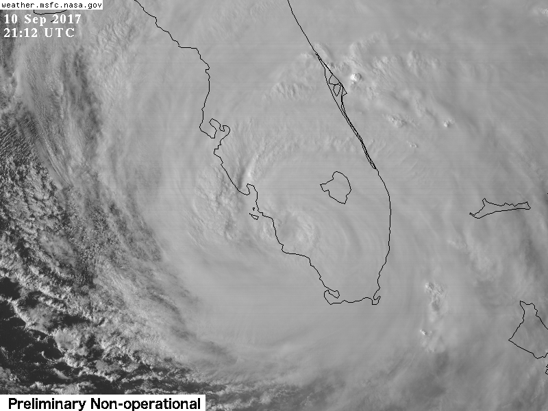
Hurricane Irma has made landfall on the mainland of the Florida Peninsula at Marco Island. The eye is directly over Naples as of the time of this post. As the winds start to shift to the west and southwest in areas south of the eye of Irma, destructive storm surge will rapidly become a serious threat to life and property. The storm has weakened somewhat to a strong Category 2 with 110 mph winds. This does not diminish the wind threat, or the storm surge, flooding rain, and tornado threat.
Current Situation
Irma’s eye has filled in again as it’s interacting with Florida. It is a large, powerful storm which easily covers the entire state of Florida. There are still widespread reports of hurricane force wind gusts along the east coast of Florida, despite the eye being on the opposite side of the state.
Headlines
Storm surge has been flooding the streets of Miami all day. The storm surge threat will become very dangerous for southwest Florida in the next couple hours as the eye moves north along the west coast of Florida. This will bring onshore winds from the west and southwest and push the ocean over land.
Onshore winds along northern Florida and the Georgia/South Carolina coasts tonight will bring a storm surge risk there as well.
Wind threat is less serious than it was when Irma was still a strong Category 4, but a 110 mph Category 2 storm is still serious. Wind gusts recorded at Naples reached 142 mph. The northern eyewall is packing the biggest punch and this will continue to advance north along the west coast of Florida.
Next cities in line for a beating will be Fort Myers, Port Charlotte, and then the Tampa Bay area.
Tornado warnings have been popping up along the east coast of Florida with some of the stronger bands of Irma.
Forecast Track
It is pretty clear now that Irma will continue north to just west of north as it traverses the state of Florida along its west coast. Tampa Bay is the largest city at risk along this path.
Forecast Intensity
Irma is still expected to maintain hurricane strength until Monday. It should pass over Tampa Bay as a strong Category 2 storm. It will continue to gradually weaken during the next 48 hours followed by more rapid weakening.
Overnight, Irma made landfall on the Cuban Keys off the north shore of Cuba. Land interaction with Cuba has eroded Irma’s circulation to the point where it is now a marginal Category 4 storm containing 130 mph peak sustained winds. However, it would be unwise for anyone in Florida to dismiss this storm for reasons discussed below.
Current Situation
Irma has been downgraded to a marginal Category 4 storm with peak sustained winds at 130 mph. Despite only barely touching the Cuban coast, it’s clear from satellite imagery that land interaction has disrupted Irma’s circulation. The eye is no longer clearly visible. The western side of the storm looks ragged.
Headlines
Track forecasts continue to shift slightly westward from overnight. This lowers the risk for a direct hit by the eye of the storm in the Miami area. However, since the strongest winds in a hurricane in the northern hemisphere occur on the east side of the storm, Miami can still expect strong wind impacts.
Hurricane force winds extend 70 miles from the eye on each side. Tropical storm force winds are 400 miles in diameter with this massive storm.
The risk to the west coast of Florida continues to increase. Southwest Florida could see the worst storm surge with surge of 6-12′ forecast.
It is not out of the question that Tampa Bay could take a direct hit from the eye of this storm at Category 3 strength.
Irma could still re-intensify over the very warm waters of the Florida Straits once it moves away from Cuba.
Tornadoes in the bands of Irma as it moves north will pose a limited but dangerous threat.
Forecast Track
The high pressure over the central Atlantic that has steered Irma to this point continues to remain strong enough to keep it on west-northwest motion along the northern coast of Cuba. Based on this latest track forecast, it is possible that Tampa Bay takes a direct hit from Irma. Portions of the Florida Panhandle are also at increasing risk. This track also enhances the risk of inland impacts in Georgia and southeastern states.
Forecast Intensity
Irma has been weakened by interaction with the north coast of Cuba. It is now a marginal Category 4 storm with sustained winds of 130 mph. While some further weakening is possible, once Irma emerges over the very warm waters of the Florida Straits, weakening should cease. It could even re-intensify over these waters before making landfall. Keep in mind that Category 3 winds would still be very serious.
Uncertainties
Any further motion into Cuba would mean further degradation to the storm’s core and circulation which could result in more weakening.
There is a window for some possible re-strengthening over the Florida Straits.
An eyewall replacement cycle could still occur bringing fluctuations to the strength of the storm.
The exact timing of Irma’s turn north is still not certain. When it turns north will have large implications for who sees the worst direct wind impacts from the eye of the storm.
This update is based on information from the National Hurricane Center’s 5PM advisory on Hurricane Irma.
Current Situation
Hurricane Irma continues to persist as a large and powerful Category 4 storm with peak sustained winds of 155 mph. Its eye still appears somewhat ragged, suggesting that it’s still undergoing an eyewall replacement cycle. This will continue to lead to fluctuations in its strength.
Headlines
Track forecast continues to edge westward. This decreases the risk Irma poses in any direct way to Georgia and South Carolina coastal areas, though storm surge threat here is still significant.
The threat of a direct hit on Miami is decreasing. However, a track to the west of Miami would result in the South Florida region being on the more dangerous eastern side of the storm.
The risk of devastating impacts to the west coast of Florida is increasing.
Irma’s eye may be moving very close to or make landfall on the northern Cuban coast. The threat of catastrophic wind and storm surge damage to Cuba’s north shore is increasing.
Risk of damage from flooding rains and tornadoes also exists. See this 1-5 day map of possible rainfall totals:
Forecast Track
Forecast models continue to edge slightly westward on a track for Irma and as such the National Hurricane Center has also adjusted its latest forecast slightly more west.
Forecast Intensity
National Hurricane Center forecasts continue to call for Irma to make landfall somewhere in South Florida as a very dangerous and powerful Category 4 storm. Outside of possible internal fluctuations and interaction with Cuba’s high terrain, there are no other inhibiting factors on Irma maintaining Category 4 strength of even possibly intensifying. Irma is entering an area of very warm sea surface temperatures with basically no mid-level wind shear.
This is one of an upcoming series of special posts dedicated to Hurricane Irma. I’m hoping these posts will keep those of you who are either in areas at risk or have friends and family there informed and prepared as this historic storm bears down on the US mainland.
Current Situation
Hurricane Irma remains an impressive Category 5 storm packing sustained wind speeds of 175 mph. It is nearing the Turks and Caicos Islands as of this time.
Headlines
The threat Irma poses to South Florida as a strong Category 4 storm continues to increase
There is a risk to the Georgia and South Carolina Coasts. This risk would increase if there’s eastward movement of the storm track, as was the case in previous track forecasts.
Major impacts are expected to the Turks and Caicos and Bahamas archipelagos
The threat to the northern coast of Cuba remains high. Hurricane watches have been upgraded to warnings.
This is a large hurricane – the larger the size of the storm, the larger the storm surge it can generate. Even if the eye of the storm misses Florida to the east, the entire state could still feel the impacts of tropical storm and hurricane force winds.
Forecast Track
Here is the National Hurricane Center’s latest official forecast with a 5-day cone of uncertainty reflecting the spread in forecast models. Models have been wavering between a more westerly and easterly track in the past 24 hours which would have big implications (see below).
Here are some actual forecast model outputs on the storm’s track.
GFS model run showing Irma very close to or making landfall on the Miami area on Sunday at 8AM
Forecast Intensity
Unless the core of the storm interacts with the high terrain of Cuba by making landfall on it, it is unlikely that Irma would weaken significantly.
Wind shear is expected to remain low at the mid-levels, which means basically zero disruption to the core of the storm. Sea surface temperatures are very warm in the Florida Straits and Bahamas. This will support the storm maintaining itself as a very powerful hurricane.
Irma is expected to approach South Florida as a dangerous Category 4 storm (sustained winds over 130 mph). Even with some interaction with Florida, Georgia and South Carolina could still expect a strong Category 2 (sustained winds > 95 mph) or a Category 3 (sustained winds > 115 mph).
Uncertainties
The critical component of forecast track uncertainty is the timing and degree of influence a mid-level trough (the dip in that solid black line in the image below) on initiating Irma to begin a turn to the north as it rounds the western periphery of the Bermuda high that has been steering it thus far. The effect of a mid-level trough is both to weaken the Bermuda high and also to exert a pull on Irma to the north.
The timing of Irma’s northward turn is significant as an earlier turn would result in a more easterly track, and a later turn would result in a more westerly track. A small deviation either way could either spare an area from a direct hit by the devastating eye of the storm or bring it right into the eye.
A track to the east that takes the center of the storm away from South Florida would result in a stronger impact on the Georgia/South Carolina coasts
A track to the west would reduce the possible dangers to Georgia and South Carolina but increase the threat to the entire Florida Peninsula. This would still result in serious impacts to South Florida.
Another factor to consider is that landfall on Cuba and any significant interaction of the core of the storm with the high mountains of Cuba would result in a weaker storm affecting Florida and other US locales
Irma’s Impacts Thus Far
Overnight into today, Hurricane Irma made landfall on several small Leeward Islands including Barbuda and Saint-Martin/Sint-Maarten. These islands took a direct hit from the eyewall of Irma, which packed sustained winds of 185 mph. This resulted in catastrophic damage to Barbuda that the prime minister described as rendering the island barely habitable. Below, you can watch some footage captured by a camera at Princess Juliana International Airport located in Sint-Maarten, the Dutch side of Saint Martin as the eyewall impacted that location.
As on Barbuda, scenes of widespread damage were to be found on Sint-Maarten as well. Here’s an infrared satellite image of Irma as its eye swallowed Anguilla and Saint-Martin/Sint-Maarten last night:
Hurricane Irma has smashed an all-time record for longest duration of winds at 185 mph in the satellite era (1970s or so onward) with these winds lasting for 36 hours. This is truly incredible considering that the strongest tropical cyclones are typically found in the Western Pacific where these storms have ample time over warm water to grow.
A quick update on TS Arthur, before a more substantial post later this afternoon. Based on the latest satellite imagery, it appears that Arthur is continuing to gather strength. You can see below that a central eye feature is beginning to form, and that spiral bands have now begun wrapping around the west side of the storm. While Arthur continues to struggle with dry air on its western side, it does seem that this is gradually being overcome. The inner core of the storm is displaying relatively symmetrical outflows, a sign that the storm is strengthening.
As of 11AM EDT, the National Hurricane Center analysis indicated that Arthur now has sustained winds of 60mph, and is moving north.