Today through mid-week, we will see mostly cloudy weather, along with soaking rains Tuesday which will also feature temperatures much below normal. Later in the week and into the weekend, we will see a warm up into summer-like weather that should last into the weekend as well. A Bermuda high sets up, a pattern more typical of late June. I will be in Cuba until May 2nd so this will be my last update for the next week at a minimum.
Rest of today – cloudy, high temperatures in the low-60s. Rain developing late and into the overnight Tuesday.
Tuesday – soaking and steady rainfall accompanying a slow moving coastal storm looks set to impact the area for the entirety of Tuesday. Along with this rain, a raw east to northeast wind will make the high temperatures in the low-50s feel even chillier.
Wednesday – showers may linger as Tuesday’s storm slowly pulls away to the east. Temperatures rebound nicely into the mid-60s, could go a touch warmer if clouds break up a bit.
Thursday – a warming trend begins on Thursday with temperatures climbing into the low-70s and mostly sunny skies.
Classic major nor’easter to bring blizzard conditions to a large swath of the Northeast Tuesday just days from the official start of spring. Areas in and around NYC likely to see snowfall accumulations of over 1 foot, locally higher. This may end up being one of the biggest snowstorms/blizzards in history for the month of March in NYC.
Rest of today – the proverbial calm before the storm. Mostly sunny, cold, with high temperatures in the low-30s.
Tuesday – a major late season nor’easter will bring heavy snow and blizzard conditions to the area. Blizzard warning in effect for the entirety of Tuesday. Snow starts falling overnight into Tuesday. Heaviest snows forecast to begin around the morning rush and continue through most of the day. Blizzard conditions expected on the coast with steady north to northeast winds 30-35mph and gusts over 45mph. Visibility near zero at times. High temperatures at or below freezing. Widespread accumulations over 1 foot and approaching or exceeding 18″ expected around the NYC metro area. Details on the storm at the end of this post.
Wednesday – lingering chance for snow showers early with wrap around moisture on the backside of the departing nor’easter. Mostly cloudy with a high near freezing.
Thursday – skies clearing, high temperatures in the low-mid 30s.
Major Blizzard to Impact the NYC Region
Winter Storm Stella, as the Weather Channel refers to it, is set to bring widespread heavy snow to the area beginning overnight Monday and continuing throughout the day Tuesday.
Impacts – Snow accumulations over 1 foot, in many cases approaching 18″. Locally higher amounts, with some areas possibly approaching 2 feet. Heavy snow and blowing snow during the day Tuesday. Snowfall rates 2-4″ per hour and possibly higher in the heaviest snow bands possible. Thundersnow may accompany the strongest snow bands. Blowing and drifting snow with steady northeast winds 30-35mph and gusts 45-50mph will contribute to blizzard conditions with near zero visibility at times. East and northeast facing shorelines may experience moderate coastal flooding during high tide cycles. Heavy, wet snow at the coast combined with high winds may lead to power outages. Hazardous travel conditions, severe disruptions to aviation likely. High confidence in storm total snowfall at this point, but there is still uncertainty about whether and where mixing could occur.
Timing – Snow begins early in the overnight hours Tuesday. Light accumulations of 2-4″ possible by daybreak. Heavy snow likely beginning during the morning rush hour and continuing through most of the work day, as well as into the evening rush hour. Winds quickly intensifying from the morning and staying steady through the evening hours. Heaviest snow tapers off in the early evening hours, but snow showers could continue overnight. Winds remain strong overnight into Wednesday. Conditions improve going into the morning Wednesday.
Discussion – an area of low pressure that had its origins in the Pacific has made its way across the northern US, impacting the Northern Plains and Upper Midwest with snow. This storm system will phase with a secondary, coastal low pressure system that is currently moving up the coast from the Southeast. As these storms merge, the coastal low will undergo rapid intensification and cyclogenesis, becoming a strong Nor’easter. This storm will be drawing on subtropical moisture, and will encounter an airmass that will be quite cold due to the presence of an Arctic high pressure system prior to the storm’s passage. These ingredients will set the stage for a classic major blizzard for the Northeast late in the winter season, only days from spring.
As always, uncertainty remains about the exact location of the heaviest snow bands with this storm. Areas that are impacted by these bands can easily rack up several more inches than surrounding areas that are spared. The storm is expected to track west of the 40°N/70°W benchmark. However, during the last model runs, the storm track has trended north and west, increasing the chances for the city itself to see the heaviest snow, in addition to areas north and west. If this track shifts west some more, warmer air off the ocean wrapping into the core of the storm from the south could induce mixed precipitation with rain cutting down on totals in the city and Long Island. If the track shifts east, heavier snow would fall over points east of the city.
We’re in for a wild ride over the course of the next 24 hours as our weather goes from possibly record-breaking warmth to what is expected to be the most significant winter storm so far this season. Significant snow accumulations over 6″ and possibly as much as a foot are expected across the region, resulting in a winter storm warning for all of the NYC metro region.
Timing
Judging by the amount of sun we’re getting, temperatures will likely hit record-breaking levels in the low-60s in the city today. They will drop steadily to around 50ºF by the evening commute as a cold front pushes through and Arctic air flows in from the north. Overnight, temperatures will continue falling rapidly to around freezing. Precipitation is expected to begin around 3-4AM Thursday here in the city and continue through the early afternoon. Unfortunately, the timing of the heaviest precipitation does look to bring significant impacts to the morning commute.
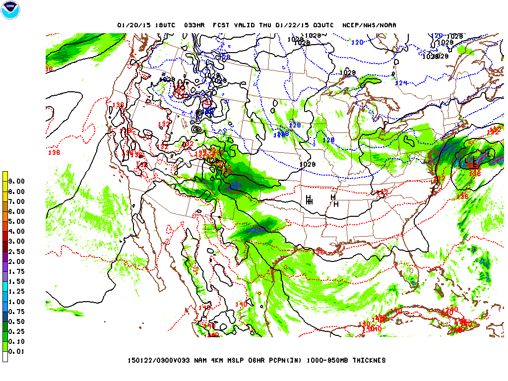
North American High Resolution simulated radar 1km resolution, tomorrow at 8AM.
Impacts
Rain/snow mix to start, but by the morning rush, expecting all snow through the region. Heavy snow at times possibly reaching 1-2″/hr. Some thundersnow could occur. Hazardous travel conditions during the morning rush as plows will have trouble keeping roads clear with traffic and the moderate to heavy snow. Gusty winds could produce near-blizzard conditions with low visibility.
Snowfall Totals
Here are some graphics for snowfall totals from our local National Weather Service Forecast office. The general forecast calls for 6″-12″ in the city. The exact extent of totals will depend, as is generally the case with this type of storm, on where the heaviest snow bands set up and for how long they sit over an any given area.
Probabilities for 4″+ and 6″+ of snow respectively
Discussion
An shortwave that’s made its way rapidly across the country from the Pacific will move along the cold front that is pushing through today. As it does so, it will spawn a secondary low off the Mid-Atlantic that will strengthen rapidly as it moves over open water. At the same time, plenty of cold air will wrap around the deepening coastal low with high pressure to the west. This will put in place all the ingredients for a classic coastal winter storm for this area. The only thing keeping this storm from being a major blizzard with snowfall totals exceeding 2 feet is the fairly quick pace that it’s expected to move at.
This coastal storm will drive the expected heavy snows tomorrow. Its track is expected to take it just outside the 40ºN 70ºW benchmark, a spot that from a climatological perspective has translated to heavy snow storms for this region.
Main weather headline to start the week will be a potent and slow-moving coastal storm bringing a variety of hazards to the region later today through tomorrow morning. This storm is the same one responsible for this weekend’s deadly tornado outbreak down south. Conditions improve dramatically towards mid-week.
Rest of today – a flood watch, coastal flood advisories, and high wind warning are in effect mostly through tomorrow morning. Cloudy with high temperatures steady around 40°F. Winds continue to increase throughout the day as a strengthening coastal low approaches and the pressure gradient between it and a high pressure center over Quebec tightens. A low-level jet will enhance winds. Sustained east and northeast winds of 30-40mph with gusts between 50-60mph will become commonplace late today and overnight. The strongest winds will occur closest to the coast.
Along with the strong winds, periods of heavy rain will bring the potential for 1-3″ of precipitation, which could lead to minor to moderate urban and small stream flooding. Timing of the onset of rain will be around 3pm this afternoon.
The persistent and strong northeast winds off the water will contribute to minor to moderate coastal flooding. This will be exacerbated during a couple of high tide cycles.
High resolution rapid refresh model simulated radar output for 3PM this afternoonThe storm approaching spans the better portion of the entire East Coast
Tuesday – rain and wind abate during the day, tapering off by the afternoon. High temperatures about the same as today in the low-40s.
Wednesday – as the coastal storm continues to pull away, temperatures rebound and mostly sunny skies return. High temperatures anticipated around 50ºF.
Thursday – another nice day with high temperatures in the upper-40s and mostly sunny skies.
The beginning of the week will see much needed rain, and then transition to sunny and above average weather. Drought conditions have improved in New York State overall, though most of the improvement has been concentrated upstate.
Rest of today/overnight – rain begins to move in to the area overnight. Because of the very dry air that was in place to end the weekend, it will take some time before the moisture associated with a coastal low can saturate the air. It appears the most likely time for when heavier/steadier rains begin is around 4AM.
Tuesday – rain, moderate to heavy at times in the morning. Northeast winds around the coastal low responsible for the rain will keep temperatures cooler than normal in the low-50s with cloudy skies. Rain chances diminish substantially in the afternoon.
Wednesday – a small chance for lingering drizzle on Wednesday as temperatures rebound back into the upper-50s. Clouds will be on the decrease.
Thursday – sunny, with a high near 60ºF. High pressure takes over to to end the week.
Drought Improves Upstate, Still Severe in and Around NYC.
Recent rains have improved the drought situation for many portions of upstate New York, and also some areas of the city and Long Island. However, as you can see from the image below, much of the area is still gripped by severe drought.
We have a fairly active weather week ahead of us, with two separate chances for rain coming from two different storms, the first of which impacts the area tomorrow and tomorrow night. The second storm system to affect us this week will make its passage on Thursday. Temperatures are much more seasonable this week with high temperatures hovering near 60 for most of the week.
Rest of today – mostly sunny with a high near 60 degrees.
Tuesday – a low pressure center over the Gulf coast today will strengthen into a coastal low as it tracks to our south and east Tuesday and Tuesday night. Like most coastal lows of this type, a large shield of overrunning precipitation will advance ahead of the actual low. This should translate to a rainy day Tuesday, with steady chances for precipitation throughout the course of the day and into the overnight hours. An east wind will also bring a cool, onshore breeze into the area, giving the day a raw feel despite high temperatures near 60.
Wednesday (Veterans Day) – looks to be bookended by wet weather, but should be a mostly dry day with more clouds than sun, and a high again near 60.
Thursday – a cold front associated with a low pressure system that’s currently over the plains will bring about our second chance for rain this week, although this round of rain should not be as long-lived or drenching as tomorrow’s storm. High temperatures should remain around 60.
NYC gets brushed by a fast-moving Alberta Clipper system, with the potential for some light accumulating snow across the area Wednesday afternoon and evening. High pressure builds behind the clipper system Thursday and Friday, with high temperatures about average for this time of year. There’s some potential for a coastal storm approaching on Saturday/Saturday night, but with considerable uncertainty at this time, it remains to be seen if this scenario pans out, and if it results in snow or rain or a mix of wintry precipitation.
Wednesday – clouds increasing through the day with high temperatures in the mid-30s. Flurries may develop in the afternoon, however, the bulk of any snow is more likely to occur later in the evening and overnight. Max accumulations of 2″ in the city (1″ is more likely).
NAM model showing precipitation over the area Wednesday, as a clipper system transfers its energy over to a coastal low which will remain well offshore.
Thursday – mostly cloudy day with some snow flurries possibly lingering into the morning. High temperatures around the mid-30s.
Friday – high pressure continues to build over the region with skies clearing and high temperatures again in the mid-30s.
Saturday – forecast models are hinting at a coastal storm for Saturday. Right now, it appears as though the storm track brings the center of the low slightly to the east of the 40ºN 70ºW benchmark. Temperature profiles in the area also appear to be around the freezing mark. This will bear monitoring, as a slight westward jog of the storm track and a cooler temperature profile could result in some significant snow.
We end this week off with a windy day Friday, followed by an intrusion of cold air on Saturday before a warmup Sunday that should be accompanied by some rain during the day, then possibly a mix of rain and snow Sunday night. Some chance of snow persists into early Monday.
Friday – a cold front dropping from Canada will tighten the pressure gradient ahead of it, bringing with it breezy west-northwest winds between 15-25mph during the day tomorrow. High temperatures will be about normal in the upper 30s, but with wind chill values only in the 20s.
Saturday – subsequent to the passage of that cold front, we get another shot of cold, arctic air, with temperatures on Saturday struggling to even reach 30 in the city, and only in the 20s elsewhere.
Sunday – a low pressure system will be moving steadily northeast into Quebec by Sunday. This storm system will have a trailing cold front as well as a preceding warm front. We should enter the warm sector behind the warm front passing over us Sunday. This will allow for temperatures to rise into the mid-40s (possibly higher in a few spots). There will be a transfer of energy to a secondary low pressure center which is forecast to form off the Mid-Atlantic coast. This will result in the chance for us to get a few periods of moderate-heavy rain on Sunday, especially in the afternoon hours. As the coastal low moves off to the northeast, rain should taper down during the overnight hours into Monday, and temperatures will be cold enough to support a chance of rain/snow mix.
Monday – snow showers should end early Monday. High temperatures will be about average for this time of year, in the upper 30s.
It’s hard to believe now, with air temperatures still hovering around 60 at this hour on Monday, that by Wednesday, our entire region could be looking at accumulating snow! Over the weekend, it has become clear through progressive model runs that the mid-week storm that on Friday looked like it would miss us, is tracking to hit us on Wednesday, leading to a high impact storm just in time for the busiest travel day of the year. We’re talking the whole package: wind, rain, and snow.
Tuesday – we continue to stay in the warm sector of a low pressure system that will be exiting to our northeast through Quebec. Cloud cover will be minimal and we should see temperatures hold around the 60 degree mark.
Wednesday – a complex weather situation develops as a coastal low that forms offshore of the Georgia/Florida border Tuesday makes its way up the Northeast coast. Temperature profiles seem to be pointing towards a mostly snow event (the first big snow storm for the region). With the cold front pushing through late Tuesday, temperatures Wednesday will likely peak in the morning around 40 and start to drop slowly through the day as precipitation moves in across the area, generally from southwest to northeast. Wind will start to pick up, first from the southeast, then east and gradually becoming northeast between 25-35mph.
The tricky part about this forecast is that there is still enough uncertainty in the storm track for there to be some last minute changes. As it currently stands, the center of the strengthening coast low is forecast to move on top of or just west of the 40ºN 70ºW benchmark, a scenario that favors a high-impact nor’easter type event for our region. Winter storm watches are already up over much of the interior Northeast. In these areas, we are looking at anywhere from 4-10″+ (depending on where the heaviest band sets up). Along the coast, under the current forecast track and methodology, it is looking like enough rain mixes in during the day Wednesday to keep snow accumulations from topping 5-6″.
Again the storm track could change, and if the track moves slightly to the east, the heavier snow could hit the city, along with some colder air. Regardless, this does not bode well for people who are doing last-minute traveling for Thanksgiving. I would expect widespread flight delays, while traffic conditions on the road could deteriorate quickly especially later in the day with temperatures dropping and snow beginning to stick.
Thursday – Thanksgiving Day itself looks like it will be OK for the parade, and other activities. The coastal storm will have pulled to our northeast, and any lingering effects should clear up early. Temperatures will be around the 40 degree mark in the city, which means that snow which accumulates will not melt all that quickly.
Friday – will be the coldest day of the holiday stretch, with temperatures only in the mid-30s. Areas of snow that have melted during Thursday could re-freeze.
The remainder of the holiday weekend looks good so far, with no major precipitation anticipated until Sunday/Monday.
This week will be a colder repeat of last week, with a wet mid-week period, but better conditions going into the weekend.
Tuesday – an area of low pressure with an accompanying cold front moving in from the Great Lakes will give us a chance of showers, especially in the afternoon Tuesday. Ahead of the front, temperatures will warm up to the mid-upper 60s under mostly cloudy skies.
Wednesday – the low pressure above will spawn a secondary low off the coast of the Mid-Atlantic. This low pressure center will be the main weather-maker for the mid-week period. Forecast models point to a stubborn storm system that will meander slowly off the Northeast. Multiple bands of rain will rotate around this low. There will be enough instability with the vorticity associated with the low to allow for the possibility of thunderstorms, despite the fact that this low will be a colder core low. Temperatures will only be in the upper 50s with a unpleasant north to northeast wind.
GFS model output for Wednesday, Oct 22, 2014 @ 8PM EDTGFS 500mb vorticity and height – notice the concentric circles indicating a closed low off the coast of the Northeast and New Engalnd. The darker yellows indicate areas of increased vorticity and energy.
Thursday – the rain should subside by around noon Thursday, but before all is said and done, we could get another 1-1.5″ of rain. The rainfall will mainly be concentrated to the east of the Hudson River, including NYC and Long Island. Temperatures will remain cool in the mid-50s with winds diminishing from the north and northwest.
Friday – the low will lift away, it will dry out, and clouds will diminish as temperatures also rebound back into the lower 60s to end the week.


