On the heels of the nor’easter earlier this week, we get another chance at snow tomorrow night into Friday, albeit of a much lighter intensity. Things get downright frigid after that with low temperatures Friday night in the single digits in the city, and wind chills below zero! The cold locks in over the weekend before we get another chance at precipitation to start off next week, continuing what has been an active weather pattern.
Thursday – clouds increase from west to east, with high temperatures hovering just above freezing. Precipitation begins overnight, and may include some rain/snow mix at the coast (all snow inland), but with minimal accumulations.
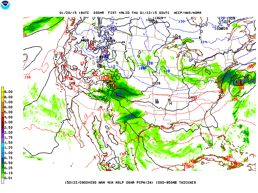
We get clipped by a clipper system Thursday night into Friday, with both NAM and GFS models pointing to us being on the periphery of the heavier precipitation.
Friday – light flurries continue into the morning Friday before ending, skies clear quickly while temperatures begin nosediving from a high in the mid-30s during the morning hours to the upper teens by sunset. Winds also pick up from the north and northwest as the departing clipper system from above deepens and the pressure gradient increases between it and a high pressure center over the Midwest. The combination of the cold temperatures and winds will likely induce wind chills below zero, so bundle up before you go out there Friday night.
Saturday – the deep freeze continues, with high temperatures only in the low 20s Saturday despite plenty of sunshine.
Sunday – another day of decent conditions, with clouds increase, but still cold with highs in the upper 20s. Sunday night into Monday, we get another shot at precipitation, although it’s a bit too early to nail down the specifics of this upcoming storm (whether it’ll be rain/snow, rain, or just snow, and how much).
As many of you woke up this morning, you were probably wondering, what happened here? This storm seemed like a dud. True, the snowfall totals in and around NYC were lower than initially forecast, but portions of the area did get slammed with over 20″ of snow. To put it simply – as I had laid out in the caveats from the last post, slight changes in track of this storm dramatically altered the placement of mesoscale banding features, hence leading to a sharp cutoff in snowfall totals from east to west.
Snowfall Totals
Looking at this snowfall totals map, you can easily make out the line that demarcates where the heaviest snow bands stopped their westward march. We got what appears to be around 6-8″ in the city, but just east of us in Nassau the totals jump to 12″ and then just east of that in Suffolk we see 20″+ totals.
Snowfall total map
On a larger scale, you can see the areas that got the highest snowfall totals, corresponding to where the heaviest bands of snow were able to pass over.
Forecasters are saying that the storm tracked further east than they expected by about 50-75 miles, which literally would have meant the difference from us having 6-8″ snowfall totals here in the city to easily 12-18″+. Now before we all go blaming them for a dud forecast (that some are already saying wasted taxpayer money), there are a couple things to consider:
Forecasters utilize a suite of different computer models to come up with these forecasts, in this case they favored the NAM (North American Mesoscale) and ECMWF (European Center for Medium Range Weather Forecasts) over the GFS (Global Forecast System), UKMET (United Kingdom Meteorology), and Canadian models. There were specific reasons for doing so, one of which is based on forecasters’ experience with these types of systems and which models have historically done a better job with them. ECMWF often does a very good job of modeling strong cyclonic systems like this (and is often favored in forecasting tropical cyclones). In this case, the NAM and ECMWF had the storm moving just far west enough to put us on the cusp of those high snowfall totals.
Mesoscale (medium scale) banding features are notoriously difficult to forecast in these types of storms. The exact position, orientation, and movement of these banding features is often not known until the storm is already ongoing. This is due to a number of complex atmospheric interactions that are responsible for these features forming. To take another example, the Storm Prediction Center can forecast that severe thunderstorms are likely over a certain area 2-3 days out. However, it is exceedingly difficult even the day of to know which towns will get hit by individual storm cells/tornadoes, etc. Despite advances in supercomputing power, forecast skill and accuracy, and understanding of meteorology, these mesoscale events remain challenging to get right even for the most experienced forecaster. So while the general public can say, “I told you so”, I’d challenge any one of them to forecast the next Nor’easter, and the one after that, and so on, and get them right with more skill than a straight up guess.
Anyway, since we all got the day off (the political response to this storm is a whole other debate beyond the scope of this blog), forget about the forecast being a dud and go out to take advantage of a day off!
A major nor’easter will be bringing a high impact blizzard throughout the NYC region tonight through Tuesday midday. Beginning this evening, snowfall will increase in coverage from south to north. Periods of heavy snow are expected with snowfall rates of 2-4″ per hour, with thundersnow occurring in the heaviest bands of snow. Extended periods of high winds, with sustained winds at least 35mph and gusts over 40mph (even up to 60mph) will lead to blowing and drifting snow, blizzard conditions, and near-zero visibility. Widespread snowfall totals of between 18″-24″ possible throughout the area, with locally higher amounts.
Snowfall Totals
Since yesterday afternoon, forecast models have backed off a bit on the overall total accumulations. At this point yesterday, the quantitative precipitation forecast (liquid water equivalent total) was as high as 2.7-2.8″ and broadly over 2.5″ across much of the area. As seen below, those liquid water equivalent numbers have gone down by about half an inch.
Liquid water equivalent forecast totals
This decrease in overall precipitable water has led to a corresponding downgrading of the overall snowfall totals. Using a 12:1 snow to water ratio, a drop in precipitable water by half an inch translates to a decrease in snow totals by 6″. Indeed, the National Weather Service has decreased the likely totals from 27″+ for many places to closer to 20-22″.
Snowfall accumulation total forecastHighest probabilities for snowfall totals in excess of 18″ during the 48 hour period ending 7AM Wednesday now rests over Southern New England, with the bullseye setting up right over Boston and immediate suburbs. Here in NYC, we are in the range of 30%-50% probability of receiving over 18″ – notice how abruptly the probability goes up as you go further north and east.
Timing
Light snow has already begun falling over the area, however the heaviest snow will not be occurring until after 8PM tonight. The most intense period of this storm is expected overnight tonight, as a deformation banding feature forms and begins moving slowly inland. Based on the simulated radar loop below from the NAM (North American Model), the peak intensity of snowfall looks like it will occur between 1AM-7AM overnight into Tuesday. Snow appears to taper off over NYC by 1PM tomorrow.
It does appear that a secondary set of banding snow will linger over eastern areas of the metro region throughout the afternoon Tuesday until as late as 4PM tomorrow.
By the way, part of the reason the main area of highest snowfall totals is now shifting to Southern New England and Boston is because it is anticipated that these areas will see moderate to heavy snow for much longer than we will here.
NAM model simulated radar output for this storm
Impacts
Snow, heavy at times, beginning in earnest this evening especially after 8PM. Some thundersnow possible, with the most intense snow occurring overnight. Strong sustained winds up to 35mph with gusts over 40mph and as high as 60mph will lead to blizzard conditions with blowing and drifting snow cutting visibilities down to near zero.
Caveats
Forecasters have been pointing out that there continues to be some slight disagreements between different models even though this storm is imminent. Snowfall total forecasts for storms like this one are notoriously difficult to predict with a high degree of accuracy prior to the event itself. This is due to the fact that the exact placement, movement, and intensity of the deformation banding feature on the northwest flank of the low pressure center is hard to foresee until the storm is ongoing. With snowfall rates as high as 2-4″ per hour within this banding feature, a difference of a couple hours under it could translate to 4-8″ difference in overall accumulation in any one location. Same thing with location, as one location that misses the most intense portion of the banding feature could easily miss out on 6″+ in total accumulation. Furthermore, a slight change in the thermal profiles within this type of storm could alter the snow to water ratio to be higher, and of course, a change from 12:1 to 15:1 would result in a dramatic difference in totals.
Yesterday’s Nor’easter will seem downright quaint by the time Tuesday morning rolls around. Just a couple of days ago, forecasters were not even clear if we’d get any precipitation Monday going into Tuesday. Now, words like “historic” are being used to describe what will undoubtedly be the biggest snowstorm of the season so far. When all is said and done, we could be looking at widespread snow totals on Tuesday of 18″ to as much as two feet of snow. During the peak of this much stronger Nor’easter, high winds and blowing snow could lead to an extended period of blizzard conditions near the coast.
The Setup
Forecast models that up to just 2 days ago were displaying significant differences as to how this system would transpire are now in close agreement on a classic setup for a strong Nor’easter, and a powerful, high-impact blizzard for the Northeast.
A relatively weak clipper-type low will be moving across the Midwest during the day today. By Monday evening, a secondary low will form from the remnants of this first system. This second low will rapidly intensify as it tracks on or just west of the 40ºN 70ºW benchmark early Tuesday morning.
NAM model output for the next couple of days
As the low bombs out (dropping more 30mb in less than a day), its forward progress will be slowed by a high pressure to the north. This high pressure over Quebec is a key difference between the setup of the storm on Saturday and this coming Nor’easter. In contrast to Saturday’s storm, this high pressure will allow a relatively deep layer of cold air to take hold prior to the arrival of this storm. As the low pressure continues moving northeast, the pressure gradient between the rapidly intensifying low and this high pressure will allow for strong winds to affect the area from first from the east, then northeast and finally north.
This combination of a slow moving, strong low pressure with ample cold air and moisture available will translate to widespread snowfall totals of over a foot, and close to 2 feet, primarily for the Hudson Valley and points east. This will primarily be due to the influence of a mesoscale deformation banding feature is expected to form north of the storm center, then slowly wrap around the storm as it moves northeast. Because the forward motion of the storm will be so slow, the banding feature (which could contain snowfall rates of 2-4″ per hour) could be sitting nearly stationary over large portions of the region for a prolonged period of time – thus leading to what could be record breaking totals.
With the wind expected to pick up during this event, there is a blizzard watch in effect for coastal areas of the region, where wind sustained winds (25-35mph) could lead to near zero visibilities while heavy snow falls.
Snowfall Totals
As you can see from below, almost the entire region is expected to pick up more than 12″, with eastern areas possibly picking up near 2 feet!
Looking at probabilities of snowfall totals below, you can see that there’s now at least a 70-80% chance a good portion of the NYC region receiving more than 8″ of snow.
This storm will also have ample moisture to draw off of, with the liquid water equivalent of between 1.5″ to over 2″ across a good part of the region. Using the standard 10-1 ratio of snow to liquid water, this would translate to between 15-20″.
Quantitative precipitation total forecasts from the Weather Prediction Center
Timing
Snow will begin Monday, with increasing intensity through the day. Winds from the northeast will also pick up during the day Monday with high temperatures only in the mid-upper 20s. Anywhere between 1-3″ of snow could fall across NYC.
The heaviest snow will be taking place overnight Monday into Tuesday morning, where parts of the area could pick up another 9-13″. Again, the heaviest snow will be occurring within the mesoscale banding feature, where intense snowfall rates of 2-4″ an hour for a prolonged period of time could even be accompanied by thundersnow. Winds will probably peak during this overnight period.
Snow will continue to fall during the day Tuesday, with another 4-8″ of snow possible. High temperatures will again only be in the upper 20s.
Rest of the Week
Wednesday – snow finally ends Tuesday night with conditions clearing by Wednesday, but high temperatures again struggling to reach the upper 20s.
Thursday – a slightly warmer day with high temperatures in the low 30s.
Friday – there’s a chance at some more precipitation (but much lighter) from a weak low pressure system moving through Friday.
The details are starting to come together for tomorrow’s Nor’easter. Over the past day, forecast models have been pointing to a faster moving system, such that the onset of precipitation is expected to begin overnight tonight, with the bulk of the precipitation ending by early afternoon tomorrow. This storm is expected to throw a little bit of everything our way tomorrow, making for a nasty day overall, with snow changing over to freezing rain or sleet, then perhaps a period of plain rain, followed by a possibility of a rain snow mix.
What to Expect
Snow, moderate to heavy at times, beginning overnight tonight. Winds picking up from southeast, then eventually moving to the northeast and north during the day Saturday. Snow transitioning to a period of possibly freezing rain or sleet during the morning hours, then a period of rain around midday and a possible rain/snow mix towards late afternoon before precipitation gradually tapers off later in the evening. High temperature right around or slightly above freezing.
Forecast Storm Track
Forecast models are in generally good agreement that the center of this Nor’easter will be passing just inside the 40ºN 70ºW benchmark sometime in the late afternoon Saturday (approx 4-5PM).
Without a high pressure center to the north supplying cold air to the area, this setup will allow for enough warm, moist air to circulate around the eastern side of the low pressure center to give us a mix of precipitation throughout the day. The extent to which snow can be sustained will be strongly dependent on dynamical cooling, and how quickly cold air can be pulled in on the western side of the low pressure center.
Storm track forecast from the Weather Prediction Center, with clusters indicating forecast positions of individual ensemble members.
Snowfall Forecast
As you can see below, the probability of more than 4″ of snow is quite low for coastal areas, especially Eastern Long Island, where mainly rain is forecast. The heaviest totals (no more than 5″, most likely) will be concentrated well north and east of NYC where temperatures are expected to be cold enough to sustain all snow for longer. Because the forward speed of the storm is now predicted to be faster, the chances of NYC getting any significant snowfall (even 2″) is considerably lower. Most of the city is in a swath of between 30-40% chance of getting more than 2″ of snow.
Probability of greater than 2″ of snowfallProbability of greater than 4″ of snowfall
Ice Accumulation
The probability of us receiving a trace, but a measurable amount of ice from freezing rain is quite a bit higher than the probability of receiving snow, with most of the city in the 40-60% range.
Probability of ice accumulation greater than .01″
Sunday – the storm will be long gone by Sunday, and we’re expecting to hit highs in the mid-upper 30s.
Monday – there is some potential for a round of all snow on Monday, but forecast models have not been in good consensus on how this will play out. A clipper system is expected to pass through, though it is unclear whether this system will spawn a secondary low offshore. In the latter case, we could see some significant snow, while if it’s just a clipper, we probably won’t see more than a couple inches.
All eyes turn towards the imminent Nor’easter that will be bringing significant winter weather impacts to the NYC metro region. Many variables remain unresolved that could affect the eventual outcome, but at this time, it looks like we’re in for a nasty combination of freezing rain, rain, and snow during the day Saturday. At present, forecasts call for somewhere between 2-4″ of snow in the city along with some ice accumulation. Precipitation should fall as all snow north and west of NYC, however, overall accumulation should be slightly less than in the city itself since the most intense precipitation will remain near coastal areas.
Friday – we get a pleasant, sunny, and slightly above average day with high temperatures in the mid-upper 30s.
Saturday – a tricky forecast for Saturday. What we know for sure, with different forecast models in relatively close agreement, is that an area of low pressure now forming over the Texas Gulf Coast will track over the Southeast, and then offshore of North Carolina by Friday night/early Saturday. Once the low moves offshore, it will rapidly intensify, and then track right on or very close to the 40ºN 70ºW benchmark by Saturday afternoon/early evening.
The uncertain part about this scenario has to do with the thermal profiles in place. With no high pressure over us or to the north pumping in cold Canadian air, the depth of cold (sub-freezing) air will be relatively shallow.
As the Nor’easter approaches us, the cyclonic flow around its center will wrap in some relatively warmer air in from the ocean and points south. This makes for a complicated picture – with warmer air aloft (see animation below) during parts of the day, and below freezing air nearer to the surface throughout points in the day, the recipe is set for at least some periods of freezing rain – precipitation that falls as rain, and then freezes on contact with a sub-freezing surface.
During the middle portion of the day, temperatures should be warm enough at the surface to support plain rain for some time, before transitioning back into freezing rain, rain/snow mix, perhaps with a period of all snow before tapering off Saturday evening.
NAM output of temperature profiles at about 4,800 feet between 10AM and 7PM Saturday. Notice the light pink indicating temperatures between 0ºC and 10ºC, which only gives way to below freezing temperatures (light blue, indicating 0ºC to -10ºC) later in the time frame. The center of the Nor’easter is located within the middle of the set of concentric rings you see near NYC.
Deviations in the storm track to the east would result in more cold air being pulled in from the action of northerly winds on the western side of the low pressure center’s cyclonic flow (less freezing rain/rain, more snow), while deviations of the track west would result in warmer air being in place (less snow, more rain). So, even a slight adjustment in the storm track could alter the thermal profiles, and subsequently what kind of precipitation we see.
Sunday – temperatures overnight Saturday will be below freezing, which would allow anything that fell and melted to refreeze. Things do clear up Sunday, with highs about average in the mid-30s, and with clouds diminishing.
Monday – there is a chance for yet another round of mainly snow, potentially heavy, as another coastal storm is possible. Highs will be close to the freezing mark, making this an all snow event if it should pan out.
NYC gets brushed by a fast-moving Alberta Clipper system, with the potential for some light accumulating snow across the area Wednesday afternoon and evening. High pressure builds behind the clipper system Thursday and Friday, with high temperatures about average for this time of year. There’s some potential for a coastal storm approaching on Saturday/Saturday night, but with considerable uncertainty at this time, it remains to be seen if this scenario pans out, and if it results in snow or rain or a mix of wintry precipitation.
Wednesday – clouds increasing through the day with high temperatures in the mid-30s. Flurries may develop in the afternoon, however, the bulk of any snow is more likely to occur later in the evening and overnight. Max accumulations of 2″ in the city (1″ is more likely).
NAM model showing precipitation over the area Wednesday, as a clipper system transfers its energy over to a coastal low which will remain well offshore.
Thursday – mostly cloudy day with some snow flurries possibly lingering into the morning. High temperatures around the mid-30s.
Friday – high pressure continues to build over the region with skies clearing and high temperatures again in the mid-30s.
Saturday – forecast models are hinting at a coastal storm for Saturday. Right now, it appears as though the storm track brings the center of the low slightly to the east of the 40ºN 70ºW benchmark. Temperature profiles in the area also appear to be around the freezing mark. This will bear monitoring, as a slight westward jog of the storm track and a cooler temperature profile could result in some significant snow.
We end this week off with a windy day Friday, followed by an intrusion of cold air on Saturday before a warmup Sunday that should be accompanied by some rain during the day, then possibly a mix of rain and snow Sunday night. Some chance of snow persists into early Monday.
Friday – a cold front dropping from Canada will tighten the pressure gradient ahead of it, bringing with it breezy west-northwest winds between 15-25mph during the day tomorrow. High temperatures will be about normal in the upper 30s, but with wind chill values only in the 20s.
Saturday – subsequent to the passage of that cold front, we get another shot of cold, arctic air, with temperatures on Saturday struggling to even reach 30 in the city, and only in the 20s elsewhere.
Sunday – a low pressure system will be moving steadily northeast into Quebec by Sunday. This storm system will have a trailing cold front as well as a preceding warm front. We should enter the warm sector behind the warm front passing over us Sunday. This will allow for temperatures to rise into the mid-40s (possibly higher in a few spots). There will be a transfer of energy to a secondary low pressure center which is forecast to form off the Mid-Atlantic coast. This will result in the chance for us to get a few periods of moderate-heavy rain on Sunday, especially in the afternoon hours. As the coastal low moves off to the northeast, rain should taper down during the overnight hours into Monday, and temperatures will be cold enough to support a chance of rain/snow mix.
Monday – snow showers should end early Monday. High temperatures will be about average for this time of year, in the upper 30s.
We start this week with a mixed bag of precipitation, currently rain, but eventually back to a wintry mix before ending. The rest of the week will be dry, with colder days on tap for the mid-week period before another warming trend to end things off.
Tuesday – once the storm system that’s responsible for today’s rain and mixed precipitation moves away, a cold front will usher in a strong area of high pressure that will dominate our weather for the mid-week period. This high pressure area will allow cold Canadian air to flow into the area from the north. High temperatures will struggle to reach the freezing mark, while a steady north wind will ensure wind chills in the teens.
Wednesday – will be similar to Tuesday in terms of sensible weather with highs in the low 30s, and partly sunny skies.
Thursday – another partly sunny day, but with slightly warmer temperatures in the mid-upper 30s, near normal.
Friday – should be essentially the same as Thursday with highs again in the mid-upper 30s. Doesn’t look like we’ll get any chance for precipitation throughout the end of the week and weekend.
This first full week of the new year has featured the coldest temperatures all winter and first noticeable snow accumulations for NYC. This weekend will see a slight warming trend, with some rain possible by Monday. Looking ahead towards the end of next week, we could get hit with a coastal storm, which may bring a mix of precipitation types to the region.
Saturday – strong high pressure builds over the area, so expect a clear day, but still quite cold with highs in the low 20s and wind chills in the teens.
Check out that high pressure over the Ohio Valley at 1036mb
Sunday – as the high pressure area moves east, winds on the backside of the high will shift towards the southwest. This will favor a rebound in temperatures to slightly below seasonal highs in the mid 30s. Cloud cover will also increase ahead of an area of low pressure approaching from the southwest.
Monday – the aforementioned broad area of low pressure will pass through on with winds persisting from the southwest. This will allow temperatures to continue climbing into the upper 30s, meaning this will primarily be a rain event, although some mixed precipitation is possible early.
Tuesday – immediately following this low, temperatures will plunge back into the upper 20s with strong Arctic high pressure moving in behind the low.


